Coal Creek Waterfalls Hike
Distance:
1.1 Miles / 1.8 kmType:
Out-and-BackDifficulty:
EasyTime to Hike:
~33 minutesFeatures:
Surface Type:
Universal AccessLoading...
Loading...
The Coal Creek Waterfalls Hike in Cedar City, Utah is an easy 1.1-mile universally-accessible out-and-back hike that leads to two waterfalls within Coal Creek, the tallest being approximately 30-feet tall.
Trails
This hike follows two named trails: Cedar Canyon Trail, Coal Creek Trail.
Universal Access
Note that this trail is universally accessible from the parking lot up to the Upper Coal Creek Falls area. There is an off-trail portion of this hike that is not universally accessible, but all of the waterfalls on this trail are visible from the paved pathway.
Hike Description
This hike begins at the main parking lot for the Cedar Canyon Trail at the coordinates provided. Hikers will head in on the main paved trail, first crossing the bridge that spans Coal Creek. Here, at the bridge crossing, is the first waterfall - aka Lower Coal Creek Falls. Lower Coal Creek Falls is about 12-15 feet tall in total and is a human-made waterfall.
Reaching Upper Coal Creek Falls
After visiting the first waterfall, hikers will head west for ~100-feet before taking a sharp left-hand turn onto the Coal Creek Trail (bike trail). Here, hikers will follow the Cedar Canyon Trail as it leads eastward and into Cedar Canyon. Along the way, hikers will get nice views of Coal Creek and the surrounding mountain / canyon slopes. Eventually, hikers will end up at the Upper Coal Creek Falls viewing area located around mile 0.45. In this GPS recording, the trail leads down and onto a gravel path, then down to Coal Creek and up the creek just a bit to reach the true base of Upper Coal Creek Falls, located around mile 0.55. Upper Coal Creek Falls is another human-made waterfall that runs down the creek along several tiers of cascades making-up the ~30-foot waterfall. Upper Coal Creek Falls is the main attraction for this hike, but the views of and from Lower Coal Creek Falls (in my opinion) were prettier as it gave more views into Cedar Canyon.
After visiting Upper Coal Creek Falls, hikers will take the same path heading back to parking for a ~1.1-mile out-and-back hike.
Parking
Hikers will find a medium-sized parking lot at the coordinates provided, located off of Center Street. The parking lot is large enough to fit just under 2 dozen vehicles as of September 2023.
Pets
Dogs are allowed only if leashed and cleaned up after.
Biking
Biking is permitted along this trail.
-
Parking
37.671664, -113.038126 -
Main Trailhead
37.671863, -113.037822 -
Lower Coal Creek Falls (approx. 12-feet tall)
37.671364, -113.038108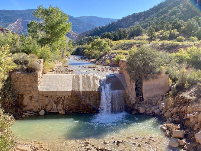
-
View of Coal Creek
37.672203, -113.0344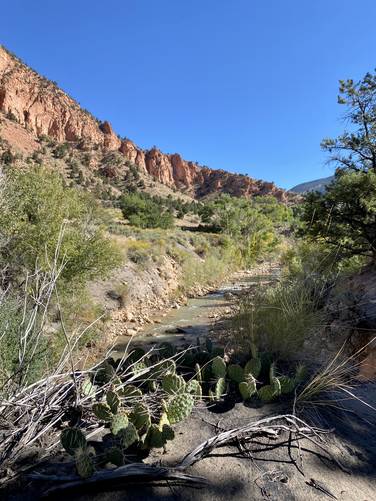
-
Upper Coal Creek Falls (approx. 30-feet tall)
37.672897, -113.033194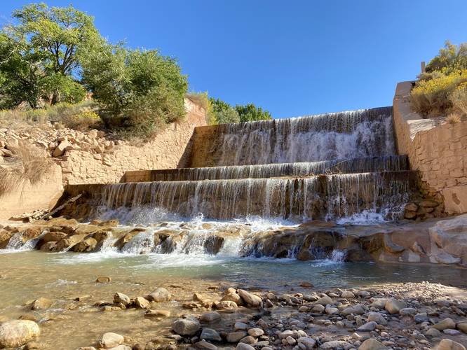
Hazards
Seasons
All
1 Trip Report


Helpful Links
Find Hiking Trails Near Me:


Before you leave...
MyHikes is an indie web platform aimed to make exploring public trails easier for everyone. The site has no investors and is owned and operated by one person, Dave Miller (Founder & Admin). As the Founder, main contributor, and doer-of-all-things for MyHikes, I share my trips with over-detailed write-ups for fun on a volunteer basis and I believe that public trail information should be available to everyone.
It takes a lot of time 🕦, money 💰, and effort (including espresso shots ☕) to run MyHikes, including hiking , mapping , writing , and publishing new trails with high-quality content... along with building new features, moderating, site maintainance, and app development for iOS and Android . I simply ask that if you find MyHikes' trail guides helpful to please consider becoming a Supporter to help keep the site, iOS, and Android apps available to everyone.
Supporters unlock website and in-app perks with a one-time payment of $25 (you renew) 😎👍. Or you can simply make a Donation of your choice without a MyHikes user account. Otherwise, telling your friends about MyHikes is the next-best thing - both quick and free 🎉
Thanks for visiting MyHikes and have a great hike!️

Dave Miller
MyHikes Founder & Admin

