Weston Lake Loop
Distance:
3.2 Miles / 5.1 kmType:
LoopDifficulty:
EasyTime to Hike:
1 hour, ~36 minutesFeatures:
Surface Type:
DirtLoading...
Loading...
The Weston Lake Loop at Congaree National Park near Hopkins, South Carolina is an easy 3.2-mile loop hike that features old-growth Cypress-Tupelo forests and views of Cedar Creek and Wise Lake.
How to reach the Trailhead
Note that hikers must first walk the Boardwalk Loop in order to reach the trailhead for this trail. If you're planning to spend a few hours at Congaree National Park and want to see more old-growth trees while experiencing the quiet tranquility of Congaree's wilderness, this trail is for you.
Hike
This hike begins at the main trailhead for the Weston Lake Loop, located near the southeast corner of the Boardwalk Loop. The trail begins by following an often-muddy dirt trail near Weston Lake with obstructed views of the lake as it meanders away from the Boardwalk Loop and into the Congaree Wilderness. Once the trail is far enough from Weston Lake, hikers will still be able to enjoy the scenic Bald Cypress and Water Tupelo swamps in addition to the old-growth forests ahead.
Old-Growth Trees - Mile 0.5 to 0.95
Starting around mile 0.5, hikers will begin to find old-growth trees located either right on trail or just off-trail with some located in the swamps. The old-growths begin with a beautiful Loblolly Pine around mile 0.5 located on-trail. Just to the south of the Loblolly, approximately less than 200-feet down the trail to the west, is a Bald Cypress tree sitting in the swamp. Around mile 0.65 is an even stranger old-growth Bald Cypress with its gnarled burl-like features -- also sitting in the swamp. Last, there are two old-growths near mile 0.9 and mile 0.95, just before the next trail junction. The last of the two old-growths is by far the largest (in diameter) that you'll find along this hike. These old-growth forests are some of the eastern United States' tallest trees. Additionally, these trees comprise one of the tallest deciduous forests remaining in the world.
Junction (Keep-Right) - Mile 1
After exploring the eastern side of the Weston Lake Loop and its old-growth forests, hikers will follow the southern section of the loop just after mile 1.
Cedar Creek Views - Mile 1 to 1.9
Once along the southern section of the loop, hikers will find many different views of Cedar Creek as the trail runs parallel for most of the way. During our hike here in early March, recent floods and the lack of leaves on the trees made for a muddy-brown landscape, but regardless it was still scenic. There are plenty of moss-covered Water Tupelo trees, decaying logs, and fern-covered Bald Cypress roots (or "knees") that jut out of the water. The trail can be muddy though, so you may spend a lot of your time hiking between puddles or trying to avoid the muddy sections.
Old-Growth Trees - Mile 1.9 to 2.1
From miles 1.9 to 2.1 are at least two old-growth trees. Unsure of their species, I thought they looked like some type of Maple, but that's speculation. There's also one natural oddity worth exploring - yet another tree - located near mile 2 sitting in Cedar Creek. The tree has grown up and over a decaying stump and appears to be fairly old itself. The gnarled finger-like roots that branch down around the decaying stump makes for a photo-worthy stop along this section of the trail.
Reaching Wise Lake's Viewpoint - Mile 2.5 to 2.33
At mile 2.5, hikers will reach a left-hand turn that leads to the viewpoint at Wise Lake. Take this turn to hike across a long bridge that spans Cedar Creek. On the opposite side of the bridge, hike straight past the trail signage to reach the banks of Wise Lake around mile 2.33. Wise Lake is similar to the other water feature views at Congaree -- it includes Water Tupelo, Bald Cypress, and the "knee" roots that stick out of the water.
Completing the loop via Sims Trail - Mile 2.4 to 3
Hikers will head back the way they came from Wise Lake to reach the previous trail junction located to the north, across Cedar Creek. Take a slight-right turn to hop on the Sims Trail (#2). The Sims Trail will lead back to the Boardwalk Loop. Along the way, hikers will find one last old-growth tree located around mile 2.9. Once at the Boardwalk Loop, hike east along that trail to reach the trailhead for the Weston Lake Loop to complete this 3.2-mile hike.
Parking
Hikers will find a couple of large parking lots at the
coordinates provided, located at the end of the national park entrance
road. The lots are large enough to fit a few dozen vehicles each and
they fill up fairly quickly each morning, by 11AM. During our visit
here, we arrived at the park at 8:30AM with ~4 other cars in the lot. By
the time we finished hiking here, it was about 11AM and almost all of
the parking lots were full. If you wish to enjoy the boardwalk loop
without many other people, show up early.
Pets
Dogs are allowed if leashed and must be cleaned up after.
Warnings
Mosquitos:
Note that Congaree National Park is known for its insane-levels of
mosquitos (and other bugs). The visitors center has a mosquito meter
located between the two restrooms near the trailhead. The mosquito meter
ranges between 1 (All Clear) to 6 (War Zone). If you want to enjoy
Congaree National Park with minimal mosquito issues, plan to visit
during the winter. During our hike here in early March 2024, we didn't
have to deal with any mosquitos. During Summer months, the meter is
likely always at 6 "War Zone".
Slippery when wet: The boardwalks and bridges along this trail can be very slippery when wet.
Flooding: Heavy rains can flood parts of this trail.
Rattlesnakes:
This area is home to the Timber Rattlesnake which can be found sunning
itself in open areas or sunny spots on warm days. Despite the popularity
of this boardwalk, you could encounter a snake as it roams the forest.
If you find a rattlesnake give it plenty of space.
Restrooms
Hikers will find restrooms and flush toilets at the visitors center near the parking lot.
What makes Congaree Special?
Congaree National Park is comprised of floodplains that sit alongside the Congaree River. Historically, these floodplains have been difficult to navigate and plunder for natural resources like timber. Due to the difficulties in logging the floodplain forests, Congaree holds a unique ecosystem of old-growth Bald Cypress and Water Tupelo trees -- along with other old-growth trees native to the eastern United States like various types of Maples. Due to the lack of logging, Congaree also holds one of the tallest deciduous canopies in the world. Tall Loblolly Pine trees also grow in Congaree's floodplains and some even reach as tall as 150-feet high. Congaree's unique swampy ecosystem is also full of various bird species and makes for a very-popular bird watching park. During our visit in March 2024, we saw at least one owl, many cardinals, and various other species of birds that we (being from the north) only see during certain seasons of the year.
-
Parking
33.830341, -80.822959 -
Main Trailhead
33.822068, -80.818002 -
Old-growth Loblolly Pine
33.817222, -80.814414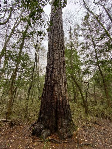
-
Old-growth Bald Cypress
33.816964, -80.814414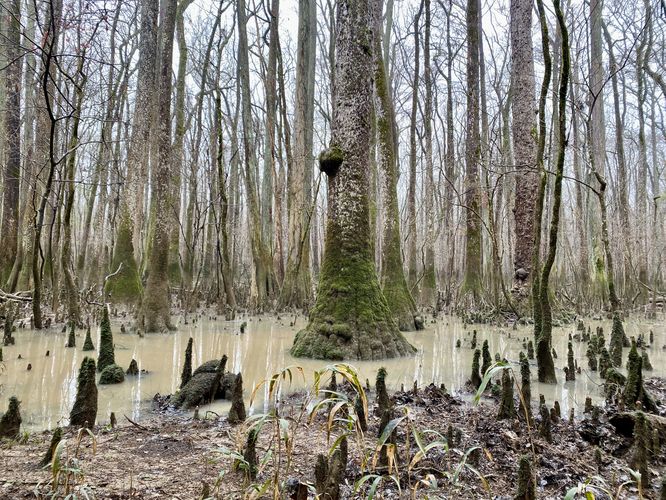
-
Old-growth tree
33.812603, -80.813033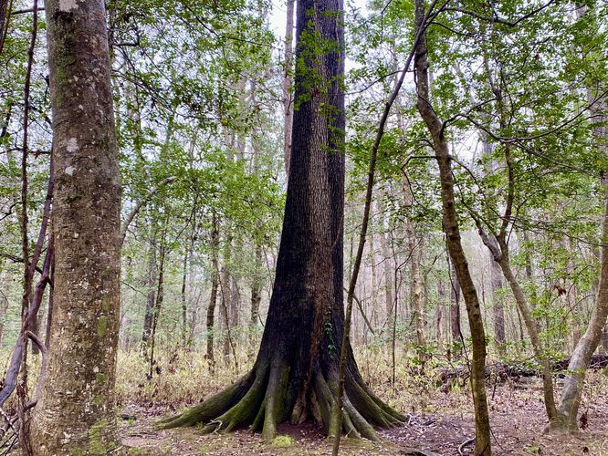
-
Old-growth Bald Cypress tree
33.811481, -80.813347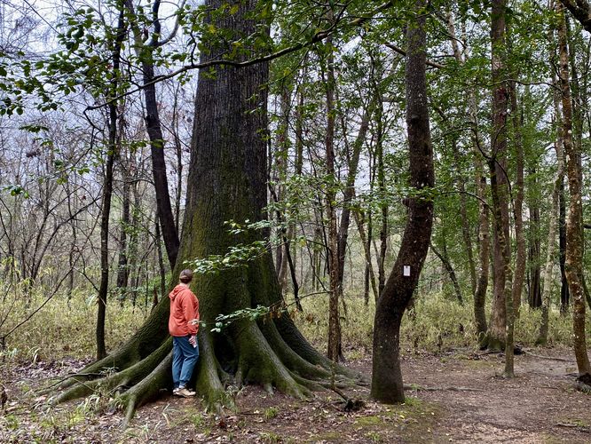
-
View of Cedar Creek
33.811986, -80.818519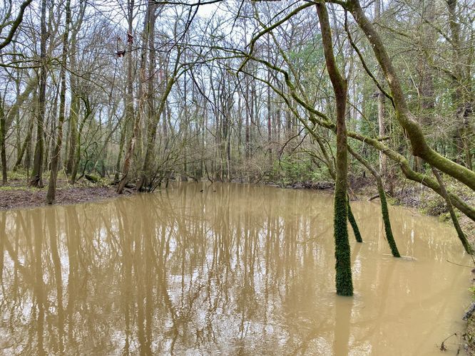
-
View of Cedar Creek
33.810306, -80.822931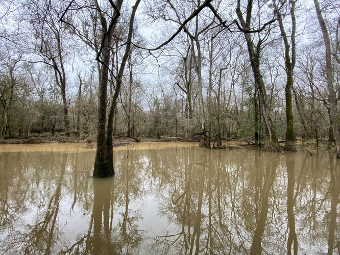
-
Old-growth tree
33.812889, -80.822914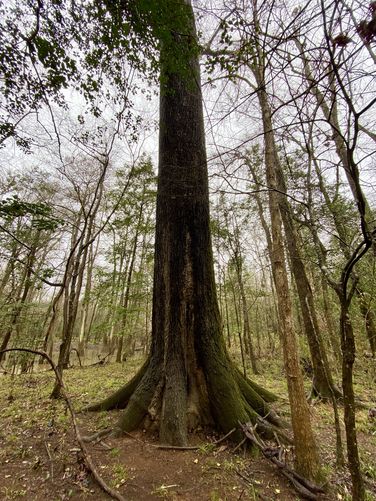
-
Tree growing over decaying stump
33.813789, -80.824044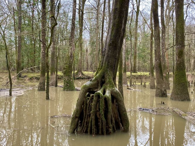
-
Old-growth tree
33.814944, -80.826089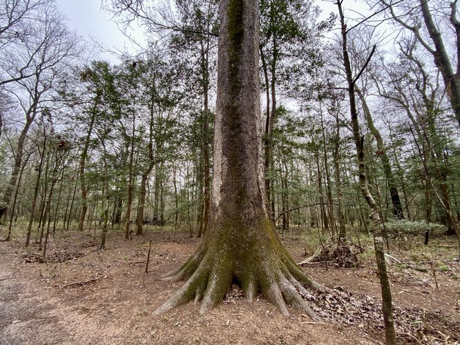
-
View of Wise Lake (Bald Cypress - Tupelo forest)
33.815236, -80.827714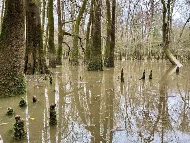
-
Old-growth tree
33.820858, -80.822297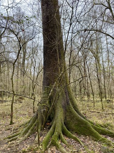
-
Old-growth Bald Cypress
33.815469, -80.813881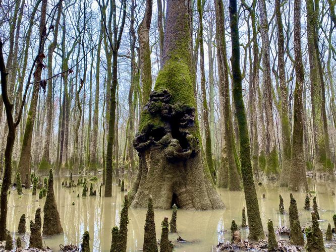
Hazards
Seasons
All
2 Trip Reports


Helpful Links
Find Hiking Trails Near Me:


")
Before you leave...
MyHikes is an indie web platform aimed to make exploring public trails easier for everyone. The site has no investors and is owned and operated by one person, Dave Miller (Founder & Admin). As the Founder, main contributor, and doer-of-all-things for MyHikes, I share my trips with over-detailed write-ups for fun on a volunteer basis and I believe that public trail information should be available to everyone.
It takes a lot of time 🕦, money 💰, and effort (including espresso shots ☕) to run MyHikes, including hiking , mapping , writing , and publishing new trails with high-quality content... along with building new features, moderating, site maintainance, and app development for iOS and Android . I simply ask that if you find MyHikes' trail guides helpful to please consider becoming a Supporter to help keep the site, iOS, and Android apps available to everyone.
Supporters unlock website and in-app perks with a one-time payment of $25 (you renew) 😎👍. Or you can simply make a Donation of your choice without a MyHikes user account. Otherwise, telling your friends about MyHikes is the next-best thing - both quick and free 🎉
Thanks for visiting MyHikes and have a great hike!️

Dave Miller
MyHikes Founder & Admin

