Angel Falls Loop
Distance:
2.8 Miles / 4.5 kmType:
LoopDifficulty:
ModerateTime to Hike:
1 hour, ~24 minutesFeatures:
Surface Type:
DirtLoading...
Loading...
The Angel Falls Loop at Loyalsock State Forest near Muncy Valley, Pennsylvania is a moderate 2.8-mile off-trail loop hike that leads to two stunning waterfalls - Gipson Falls and Angel Falls (~70-feet tall).
Trails:
This hike follows the Loyalsock Trail (yellow blazes) most of the way but does go off trail in order to loop up Falls Run and past Gipson Falls and Angel Falls, but gets you spectacular views of these two waterfalls.
Parking:
There is a good sized pull off along Brunnerdale Road for the Loyalsock Trail at 41.385234, -76.66839 and is enough for several vehicles.
Hike:
This hike starts by following the Loyalsock Trail (LT) into the forest and along Ogdonia Creek. I typically hike this loop clockwise and leave the Loyalsock Trail at about 0.4 of a mile. The LT turns right and ascends - go left and follow the grade as it stays near Ogdonia Creek. Upon reaching Falls Run at about 0.7 of a mile you will now begin the most rugged portion of the hike.
Follow the run as you hike by several cascades leading up to Gipson Falls, I typically work to the left of the run as I hike and reach Gipson Falls at about 1 mile into the hike. The hike continues by working your way up around the rock ledges to the top of Gipson Falls. Once you are at the top, the ~70-foot tall Angel Falls will come into view. The area around the bottom of Angel Falls is quite rugged and the waterfall is about 70 feet tall with large rock walls to the sides. Like before around Gipson Falls to reach the top of the waterfall, you will work your way around rock ledges to the left. Once you reach the top of Angel Falls you will see some blue blazes. These blue blazes will take you back to the Loyalsock Trail. Once you connect back with the Loyalsock Trail, you will go right and follow the trail all the way back to the parking area.
Camping & Backpacking:
While there are no designated campsites along this trail, Loyalsock State Forest is open to primitive / dispersed / backcountry camping. If planning to stake out a campsite along/near this trek, please follow all state forest rules and regulations.
Difficulty:
This hike should be considered moderate at the easiest; however, the average hike who may not be as experienced in off-trail navigation may find the steep terrain and way-finding more challenging.
Warnings:
Off-trail hiking: Only experienced off-trail hikers should attempt this trek as it leads up along very-steep terrain to reach waterfalls that are off of the beaten path.
Steep terrain & cliffs: This hike leads through areas of very-steep terrain, including cliffs at the top of the waterfalls. Hikers should be experienced and comfortable navigating steep terrain off-trail. Note that sometimes these shale cliffs and ledges can break-off, so you must be extra careful.
Rattlesnakes: This area is home to the Timber Rattlesnake which can be found roaming the forest between the end of April and early October each year. Be on the lookout and give any rattlers you find plenty of space.
-
Parking
41.385234, -76.66839 -
Main Trailhead
41.385234, -76.66839 -
Gipson Falls
41.3932, -76.677272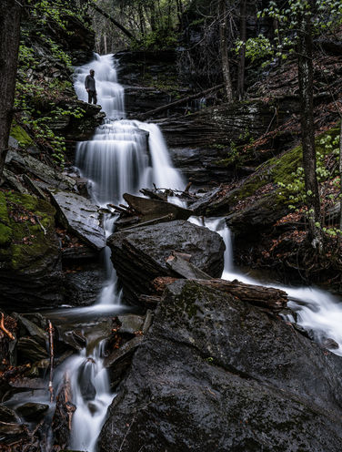
-
Angel Falls
41.39415, -76.677139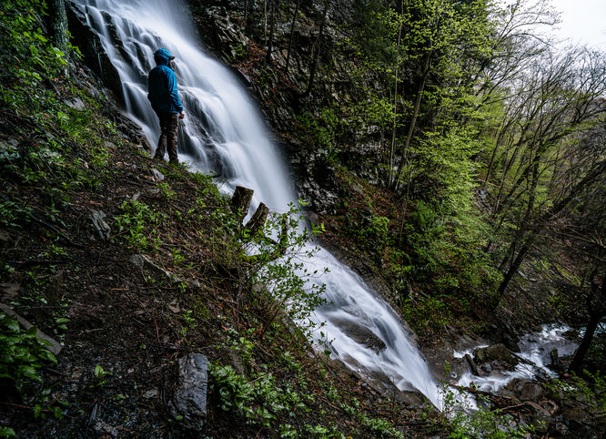
Hazards
Seasons
AllBlaze Color

1 Trip Report


Helpful Links
Find Hiking Trails Near Me:


Before you leave...
MyHikes is an indie web platform aimed to make exploring public trails easier for everyone. The site has no investors and is owned and operated by one person, Dave Miller (Founder & Admin). As the Founder, main contributor, and doer-of-all-things for MyHikes, I share my trips with over-detailed write-ups for fun on a volunteer basis and I believe that public trail information should be available to everyone.
It takes a lot of time 🕦, money 💰, and effort (including espresso shots ☕) to run MyHikes, including hiking , mapping , writing , and publishing new trails with high-quality content... along with building new features, moderating, site maintainance, and app development for iOS and Android . I simply ask that if you find MyHikes' trail guides helpful to please consider becoming a Supporter to help keep the site, iOS, and Android apps available to everyone.
Supporters unlock website and in-app perks with a one-time payment of $25 (you renew) 😎👍. Or you can simply make a Donation of your choice without a MyHikes user account. Otherwise, telling your friends about MyHikes is the next-best thing - both quick and free 🎉
Thanks for visiting MyHikes and have a great hike!️

Dave Miller
MyHikes Founder & Admin

