Wetland Bluff Trail
Distance:
0.3 Miles / 0.5 kmType:
One-WayDifficulty:
EasyTime to Hike:
~9 minutesFeatures:
Surface Type:
DirtLoading...
Loading...
The Wetland Bluff Trail at Boyce Mayview Park in Upper Saint Clair, Pennsylvania is an easy 0.3-mile one-way trail that features an obstructed vista labeled the Valley View Point.
Hike Description
This trail begins along the Field Trail and heads west to connect with the Wetland Trail and passes the Valley View Point along the way. The trail passes several sections of ravines where the path becomes a lot skinnier, so watch your step.
Around mile 0.1 hikers will reach the Valley View Point, which is an obstructed vista of the valley below. As of April 2021, the valley below appears to be a brand new housing development that’s under construction, so unfortunately what likely used to be a view of a nice empty green-space is now becoming more housing. The view here is just as obstructed as the “views” along the Queen Maple Trail or from the top of the Sylvan Ridge Trail - it’s not all that impressive, but it’s still a nice change of scenery.
Pets
Dogs are allowed on this trail.
Parking
Hikers will find parking at the coordinates provided along Birds Meadow Drive, right off of Boyce Road in Upper St. Clair. The parking lot is large enough to fit about a dozen vehicles.
Biking
Biking is not allowed along this trail.
Connecting Trails
This trail connects with Wetlands Trail and the Field Trail.
-
Parking
40.317925, -80.109013 -
Main Trailhead
40.321656, -80.105951 -
Valley View Point
40.322628, -80.106231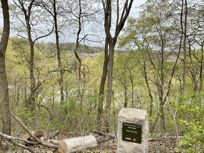
Hazards
Seasons
All
2 Trip Reports


Helpful Links
Find Hiking Trails Near Me:


Before you leave...
MyHikes is an indie web platform aimed to make exploring public trails easier for everyone. The site has no investors and is owned and operated by one person, Dave Miller (Founder & Admin). As the Founder, main contributor, and doer-of-all-things for MyHikes, I share my trips with over-detailed write-ups for fun on a volunteer basis and I believe that public trail information should be available to everyone.
It takes a lot of time 🕦, money 💰, and effort (including espresso shots ☕) to run MyHikes, including hiking , mapping , writing , and publishing new trails with high-quality content... along with building new features, moderating, site maintainance, and app development for iOS and Android . I simply ask that if you find MyHikes' trail guides helpful to please consider becoming a Supporter to help keep the site, iOS, and Android apps available to everyone.
Supporters unlock website and in-app perks with a one-time payment of $25 (you renew) 😎👍. Or you can simply make a Donation of your choice without a MyHikes user account. Otherwise, telling your friends about MyHikes is the next-best thing - both quick and free 🎉
Thanks for visiting MyHikes and have a great hike!️

Dave Miller
MyHikes Founder & Admin

