Robert Frost Trail - Station Road to Rt 9
Distance:
2.5 Miles / 4.0 kmType:
Out-and-BackDifficulty:
EasyTime to Hike:
1 hour, ~15 minutesFeatures:
Surface Type:
DirtLoading...
Loading...
This short portion of the Robert Frost Trail is an easy 2.5 mile out-and-back hike located on Station Rd in Amherst Ma next to the Norwottuck Rail Trail.
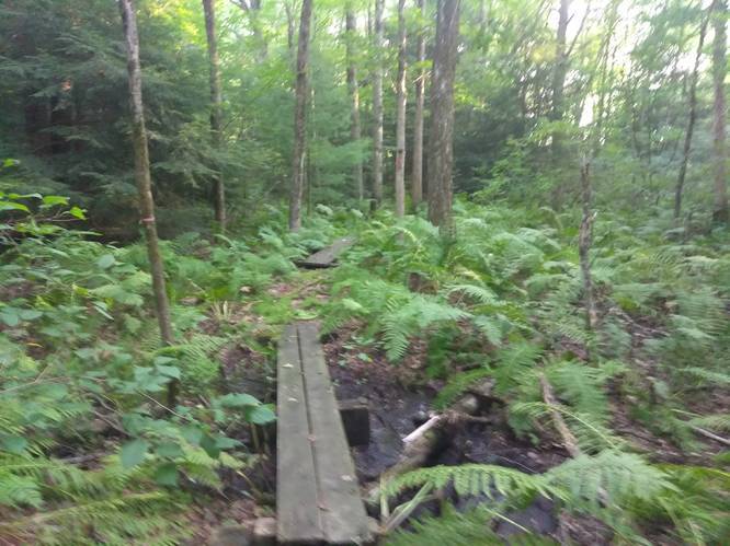
The trail is usually very wet and over grown during warmer months, but clearly traveled. The first portion is not very fun, but it opens up quickly with many plank bridges over the wet terrain.
It winds north and spits out onto Woodlot Rd - from here take a left and follow the road a short distance where the trail picks back up on the right-hand side of the road. This next portion slips between property lines for about a tenth of mile and is well maintained. The trail then spits out onto Teaberry Lane where you have an option to cross the street and continue on the trail itself as it weaves behind several houses and comes out on Wildflower Drive or turn left onto Teaberry for a more direct route where the trail picks back up on Wildflower.
When the trail resumes again on Wildflower, continue north towards Rt 9, over a few gentle hills beside Pomeroy Pond. Officially the trail comes out on Old Belchertown Rd and picks up across the street for a short section to Rt 9; however, there are no clear blazes and the trail seems to loop or meander into private property. The best option is to either turn back or walk down Old Belchertown Rd to Rt 9 and pick the trail back up there.
Parking: Parking is provided at the entrance to the Norwottuck Rail Trail. Head west over the rail road track to the trailhead.
Hazards
Seasons
AllBlaze Dot
1 Trip Report


Helpful Links
Find Hiking Trails Near Me:


Before you leave...
MyHikes is an indie web platform aimed to make exploring public trails easier for everyone. The site has no investors and is owned and operated by one person, Dave Miller (Founder & Admin). As the Founder, main contributor, and doer-of-all-things for MyHikes, I share my trips with over-detailed write-ups for fun on a volunteer basis and I believe that public trail information should be available to everyone.
It takes a lot of time 🕦, money 💰, and effort (including espresso shots ☕) to run MyHikes, including hiking , mapping , writing , and publishing new trails with high-quality content... along with building new features, moderating, site maintainance, and app development for iOS and Android . I simply ask that if you find MyHikes' trail guides helpful to please consider becoming a Supporter to help keep the site, iOS, and Android apps available to everyone.
Supporters unlock website and in-app perks with a one-time payment of $25 (you renew) 😎👍. Or you can simply make a Donation of your choice without a MyHikes user account. Otherwise, telling your friends about MyHikes is the next-best thing - both quick and free 🎉
Thanks for visiting MyHikes and have a great hike!️

Dave Miller
MyHikes Founder & Admin

