Roadside Ruin Trail
Distance:
0.3 Miles / 0.5 kmType:
LoopDifficulty:
EasyTime to Hike:
~9 minutesSurface Type:
DirtLoading...
Loading...
The Roadside Ruin Trail at Canyonlands National Park near Moab, Utah is an easy 0.3-mile loop hike that features an ancient Native American structure.
Hike Description
This very short hike begins along the Needles Main Park Road (main entrance road to Canyonland's Needles District) and heads in along the main trailhead heading in a counter-clockwise direction. The trail itself is easy to follow with minimal tripping hazards and follows a defined path that heads downhill and then up a short spur trail to reach the roadside ruins.
Ancient Roadside Ruins - Mile 0.14
Around mile 0.14, hikers will reach the ancient Native American ruins that sit under a large cave overhang. This natural rock overhang has protected this ancient ruin for nearly 700-years or so, allowing visitors to take a glance at what ancient indigenous people's used to preserve or store food to help survive the harsh desert heat and sun. Please do not climb up to or touch these ancient ruins.
After visiting the ruins, hikers will head out along the loop path following an easy uphill ascent to reach parking.
History
Indigenous people long survived here through hard work and ingenuity. Nearly 700 years ago, some built these small structures, possibly to use for storage or ceremonial purposes. In Canyonlands, even older structures still stand, but archeologists have found few villages. This suggest that early inhabitants farmed intensively, yet may have lived here only seasonlly. Without human impact, these masonry structures can survive for centuries in the desert climate. Please help protect these places by not climbing u to or entering structures. Any contact can erode foundations and weaken walls.
Parking
Hikers will find a parking turnout at the coordinates provided. The turnout is large enough to fit less than 10 cars max.
Pets
Dogs are not allowed on any trails at Canyonlands National Park. Please do not bring your dog here.
Warning
Sun exposure: This trail has very little shade and no water sources. Pack-in all water and wear sun screen and a hat to protect against sun exposure. It's smart to hike either in the early morning or late afternoon to avoid the intense desert sun.
Lack of water:
Hikers must pack-in all water as there are no potable or filterable
water sources along this trail. Rule of thumb in the desert is to
pack-in 1 gallon of water per person per day.
Rattlesnakes: This is rattlesnake territory, so be on the lookout and give any rattlers you find plenty of space.
Fees
Vehicle entry fees to Canyonlands National Park is $30 as of September 2023.
-
Parking
38.163219, -109.762627 -
Main Trailhead
38.163198, -109.762559 -
Ancient Native American ruins
38.163636, -109.760392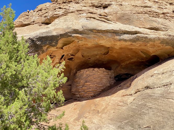
Hazards
Seasons
All
2 Trip Reports


Helpful Links
Find Hiking Trails Near Me:


Before you leave...
MyHikes is an indie web platform aimed to make exploring public trails easier for everyone. The site has no investors and is owned and operated by one person, Dave Miller (Founder & Admin). As the Founder, main contributor, and doer-of-all-things for MyHikes, I share my trips with over-detailed write-ups for fun on a volunteer basis and I believe that public trail information should be available to everyone.
It takes a lot of time 🕦, money 💰, and effort (including espresso shots ☕) to run MyHikes, including hiking , mapping , writing , and publishing new trails with high-quality content... along with building new features, moderating, site maintainance, and app development for iOS and Android . I simply ask that if you find MyHikes' trail guides helpful to please consider becoming a Supporter to help keep the site, iOS, and Android apps available to everyone.
Supporters unlock website and in-app perks with a one-time payment of $25 (you renew) 😎👍. Or you can simply make a Donation of your choice without a MyHikes user account. Otherwise, telling your friends about MyHikes is the next-best thing - both quick and free 🎉
Thanks for visiting MyHikes and have a great hike!️

Dave Miller
MyHikes Founder & Admin

