Quinault River Trail
Distance:
20.3 Miles / 32.7 kmType:
Out-and-BackDifficulty:
HardTime to Hike:
10 hours, ~9 minutesFeatures:
Surface Type:
DirtLoading...
Loading...
The Quinault River Trail in Olympic National Park is a difficult 20.3-mile out-and-back trail that meanders its way through majestic and lush old growth rainforest while following the incredibly scenic Quinault River. Along the way, cross Pony Bridge and take in the churning chasm of aquamarine blue water below vertical fern-lined walls. In season, enjoy a myriad of springtime blooming shade and part-sun loving wildflowers.
The first part of the hike starts out along the south side of the river valley, first crossing the river across a large, sturdy wooden bridge, then following high and well above sound of the river. The trail is lined with lush mosses and understory shade plants like ferns and vanilla leaf. Massive old growth evergreen trees make up much of the forest canopy. Soon the trail then starts to switchback down the steep slope down to the river and Pony Bridge. Campsites can be found at Pony Bridge too.
Cross the river on this sturdy wooden bridge, taking in the awe inspiring view down into the narrow canyon, its vertical black basalt walls lined with hundreds of ferns.
Once across the river, there are a handful of campsites. Permits are required to camp at all campsites; see the national park website for details on hiking and overnight camping permits. Bear hanging wires provided here, too.
Beyond Pony Bridge, the trail follows high above on the north side of the river. It undulates up and down, traversing across steep slopes. Some views of the river can be had.
Later on, the trail makes its way deeper into the forest, further away from the river. Lush forest of massive old growth conifer trees, like western hemlock, sitka spruce, and douglas fir; as well as deciduous trees like bigleaf maple, dogwood, and alders make up the scenery. Ferns and other shade loving plants abound all throughout. Along the way, the trail passes a variety of smaller environs of various forest types. Some mostly deciduous, some mostly coniferous, and others mixed. Some parts gently meandering along pleasant, flat river bottoms; other sections traversing high above the river across more montane forest environs.
Keep going as far as you like, passing O'Neil Camp (bear hanging wires provided), and other various campsites. Dozens of creeks cross the trail between Pony Bridge and O'Neil Camp. Beyond this camp, various other dispersed camps like beyond. You can eventually keep going and climb higher to the Enchanted Valley, a large vast meadow surrounded by towering steep faced mountains and dozens of cascading waterfalls. Beyond Enchanted Valley, the trail climbs even steeper up to Anderson Pass. From Anderson Pass, a number of options lie ahead.
Camping
Permits are required to camp at all campsites; see the national park
website for details on hiking and overnight camping permits. Bear
hanging wires provided at most of the campsites, too.
Warnings
This valley is habitat for black bears. It is very common for hikers to
encounter black bears along this trail, in particular, in the Olympic
National Park. Hike this trail with the expectation that there is a
pretty good chance you will see a bear or two. I saw two bears on my
hike. Bears here are very well accustomed to seeing people, never have
really presented any problems in the past. You shouldn't have any issues
with them, but nevertheless, know and practice the recommended bear
safety guidelines as always.
Seasons
Spring, Summer, Fall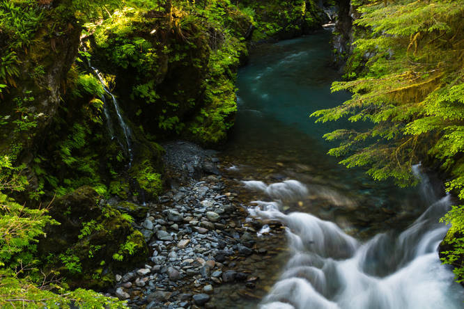
1 Trip Report


Helpful Links
Find Hiking Trails Near Me:


")
Before you leave...
MyHikes is an indie web platform aimed to make exploring public trails easier for everyone. The site has no investors and is owned and operated by one person, Dave Miller (Founder & Admin). As the Founder, main contributor, and doer-of-all-things for MyHikes, I share my trips with over-detailed write-ups for fun on a volunteer basis and I believe that public trail information should be available to everyone.
It takes a lot of time 🕦, money 💰, and effort (including espresso shots ☕) to run MyHikes, including hiking , mapping , writing , and publishing new trails with high-quality content... along with building new features, moderating, site maintainance, and app development for iOS and Android . I simply ask that if you find MyHikes' trail guides helpful to please consider becoming a Supporter to help keep the site, iOS, and Android apps available to everyone.
Supporters unlock website and in-app perks with a one-time payment of $25 (you renew) 😎👍. Or you can simply make a Donation of your choice without a MyHikes user account. Otherwise, telling your friends about MyHikes is the next-best thing - both quick and free 🎉
Thanks for visiting MyHikes and have a great hike!️

Dave Miller
MyHikes Founder & Admin

