Pratt's Falls Trail
Distance:
0.3 Miles / 0.5 kmType:
Out-and-BackDifficulty:
ModerateTime to Hike:
~9 minutesFeatures:
Surface Type:
PavedLoading...
Loading...
Pratt's Falls Trail at Pratt's Falls Park near Pompey, New York is a moderate 0.3-mile out-and-back hike that leads to an overlook of the 137-foot tall waterfall, Pratt's Falls.
Hike Description
This is less of a hike and more of a short walk that begins at the main large parking lot at Pratt's Falls Park and heads in along the paved trail that leads to the waterfall. Visitors will find a series of staircases just a couple-hundred feet into the walk where they'll follow the stairs downhill, most of the way, to reach the waterfall overlook. Note that visitors will want to take a left-hand turn at the junction shortly after reaching the bottom of the first set of stairs.
Pratt's Falls Overlook - Mile 0.15
The trail will end around mile 0.15 at the overlook for Pratt's Falls. Pratt's Falls cascades over the steep gorge at 137-feet tall, giving visitors a spectacular and quick payout.
Parking
Hikers will find a very large parking lot at the coordinates provided at Pratt's Falls Park. The parking lot is large enough to fit several dozen vehicles.
Pets
Dogs are allowed only if leashed and cleaned up after.
Surface Type
This trail follows a paved path which is universally accessible only to the staircase, located 200-feet from the trailhead at the parking lot. Once at the stairs, there are several staircases that lead down to the waterfall's overlook.
-
Parking
42.931739, -75.993212 -
Main Trailhead
42.931797, -75.993247 -
Pratt's Falls (137-feet tall)
42.9318, -75.99459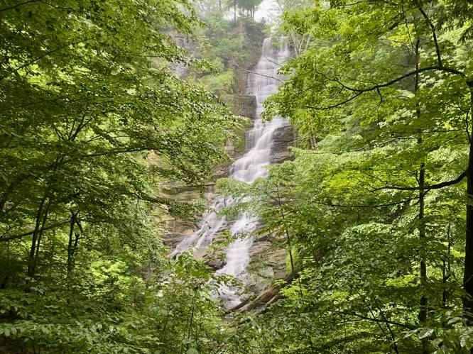
Hazards
Seasons
All
1 Trip Report


Before you leave...
MyHikes is an indie web platform aimed to make exploring public trails easier for everyone. The site has no investors and is owned and operated by one person, Dave Miller (Founder & Admin). As the Founder, main contributor, and doer-of-all-things for MyHikes, I share my trips with over-detailed write-ups for fun on a volunteer basis and I believe that public trail information should be available to everyone.
It takes a lot of time 🕦, money 💰, and effort (including espresso shots ☕) to run MyHikes, including hiking , mapping , writing , and publishing new trails with high-quality content... along with building new features, moderating, site maintainance, and app development for iOS and Android . I simply ask that if you find MyHikes' trail guides helpful to please consider becoming a Supporter to help keep the site, iOS, and Android apps available to everyone.
Supporters unlock website and in-app perks with a one-time payment of $25 (you renew) 😎👍. Or you can simply make a Donation of your choice without a MyHikes user account. Otherwise, telling your friends about MyHikes is the next-best thing - both quick and free 🎉
Thanks for visiting MyHikes and have a great hike!️

Dave Miller
MyHikes Founder & Admin

