Natural Bridge Overlook
Distance:
0.1 Miles / 0.2 kmType:
Out-and-BackDifficulty:
EasyTime to Hike:
~5 minutesFeatures:
Surface Type:
Universal AccessLoading...
Loading...
The Natural Bridge Overlook at Bryce Canyon National Park near Bryce Canyon
City, Utah is an easy 0.1-mile out-and-back walk that features a stunning natural bridge arch within Bryce Canyon.
This is not a hike but rather
a short walk that follows a universally-accessible paved path that leads to a
stunning overlook of Bryce Canyon where visitors will find a very large rock arch formation named the Natural Bridge. This short walk is one of the best overlooks at the park as it leads to one of the most interesting points-of-interest along the rim of Bryce Canyon.
Universal Access
This trail includes a paved universal access pathway.
Fees
Bryce Canyon National Park has a $35/week entry fee as of September 2023. Visitors are highly encouraged to purchase an annual National Parks pass
before their trip to reduce entry fees (especially if you're passing
through multiple parks) and to also speed-up the very-long line that
leads into the park.
Parking
Visitors will find a large parking lot at the coordinates provided.
Pets
Dogs
are only allowed on paved surfaces at Bryce Canyon National Park like
parking lots and fully paved trails, as of September 2023.
Please read
more about Bryce Canyon National Park's pet policy here.
-
Parking
37.531916, -112.260576 -
Main Trailhead
37.531916, -112.260576 -
Bryce Canyon's Natural Bridge
37.53175, -112.2603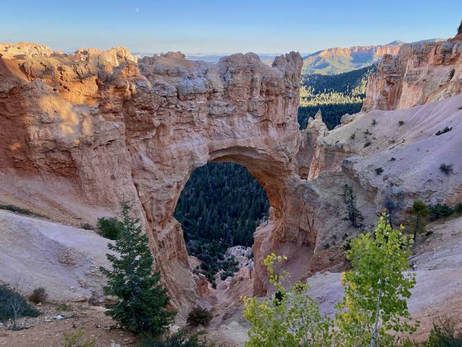
Hazards
Seasons
All
2 Trip Reports


Helpful Links
Find Hiking Trails Near Me:


Before you leave...
MyHikes is an indie web platform aimed to make exploring public trails easier for everyone. The site has no investors and is owned and operated by one person, Dave Miller (Founder & Admin). As the Founder, main contributor, and doer-of-all-things for MyHikes, I share my trips with over-detailed write-ups for fun on a volunteer basis and I believe that public trail information should be available to everyone.
It takes a lot of time 🕦, money 💰, and effort (including espresso shots ☕) to run MyHikes, including hiking , mapping , writing , and publishing new trails with high-quality content... along with building new features, moderating, site maintainance, and app development for iOS and Android . I simply ask that if you find MyHikes' trail guides helpful to please consider becoming a Supporter to help keep the site, iOS, and Android apps available to everyone.
Supporters unlock website and in-app perks with a one-time payment of $25 (you renew) 😎👍. Or you can simply make a Donation of your choice without a MyHikes user account. Otherwise, telling your friends about MyHikes is the next-best thing - both quick and free 🎉
Thanks for visiting MyHikes and have a great hike!️

Dave Miller
MyHikes Founder & Admin

