Nakalele Lookout
Distance:
0.1 Miles / 0.2 kmType:
Out-and-BackDifficulty:
EasyTime to Hike:
~5 minutesFeatures:
Surface Type:
DirtLoading...
Loading...
The Nakalele Lookout near Honokohau, Hawaii (Maui) is an easy 0.1-mile out-and-back walk that leads to a lookout point with views of Nakalele Point.
Walk Description
This is not a hike but rather a quick mostly-flat walk that follows an old undulating lava flow out to a lookout point. From the lookout, hikers get a view of Nakalele Point which juts out along Maui's northern rugged coastline. The lava flow that you walk along to reach the lookout is full of large shallow potholes, which fill-up with rain almost constantly due to the abundant rain on Maui's northern shore. You may find that you have to create your own path to and from parking by dodging puddles.
Parking
Hikers will find a small parking turnout at the coordinates provided, large enough to fit about 5 vehicles.
Pets
Dogs are allowed if leashed and cleaned up after.
Respecting the Land
Hawaiian land is considered sacred to native Hawaiians and many locals, so please stay on-trail, take nothing but photos, and leave nothing but footprints. Respect the locals - don't stay for long and have a backup hike planned in case the parking lot is full.
-
Parking
21.029465, -156.595295 -
Main Trailhead
21.029502, -156.595355 -
View of Nakalele Point
21.030183, -156.595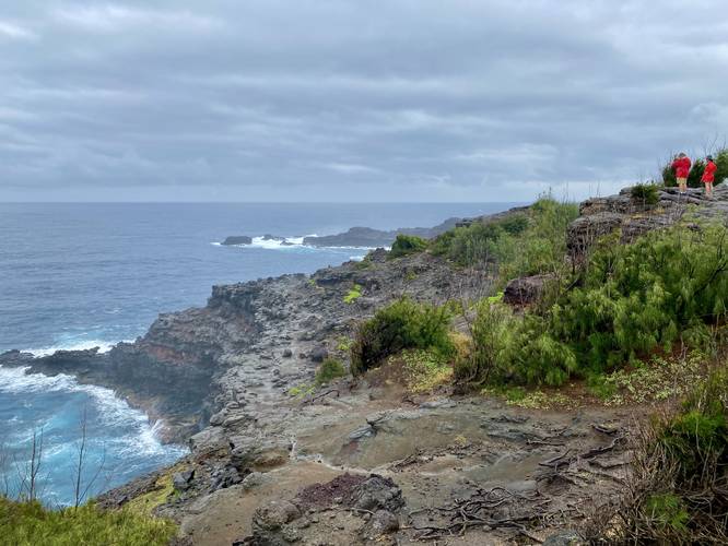
Hazards
Seasons
All
2 Trip Reports


Helpful Links
Find Hiking Trails Near Me:


Before you leave...
MyHikes is an indie web platform aimed to make exploring public trails easier for everyone. The site has no investors and is owned and operated by one person, Dave Miller (Founder & Admin). As the Founder, main contributor, and doer-of-all-things for MyHikes, I share my trips with over-detailed write-ups for fun on a volunteer basis and I believe that public trail information should be available to everyone.
It takes a lot of time 🕦, money 💰, and effort (including espresso shots ☕) to run MyHikes, including hiking , mapping , writing , and publishing new trails with high-quality content... along with building new features, moderating, site maintainance, and app development for iOS and Android . I simply ask that if you find MyHikes' trail guides helpful to please consider becoming a Supporter to help keep the site, iOS, and Android apps available to everyone.
Supporters unlock website and in-app perks with a one-time payment of $25 (you renew) 😎👍. Or you can simply make a Donation of your choice without a MyHikes user account. Otherwise, telling your friends about MyHikes is the next-best thing - both quick and free 🎉
Thanks for visiting MyHikes and have a great hike!️

Dave Miller
MyHikes Founder & Admin

