Montezuma's Well Trail
Distance:
0.7 Miles / 1.1 kmType:
LoopDifficulty:
EasyTime to Hike:
~21 minutesFeatures:
Surface Type:
PavedLoading...
Loading...
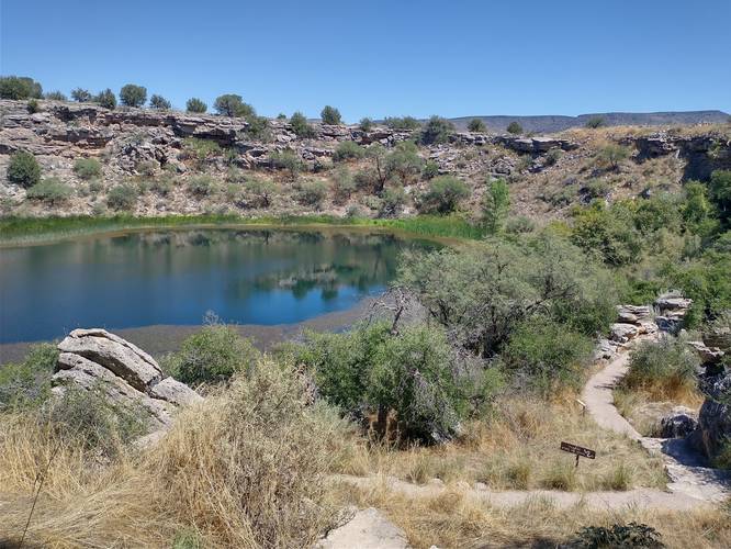
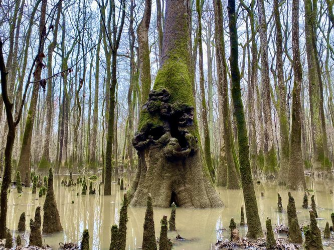
Montezuma's Well Trail at Montezuma Castle National Monument in Rimrock, Arizona is an easy 0.7-mile loop hike that features ancient Native American dwellings along with the desert oasis spring known as Montezuma's Well.
Trail names: Montezuma's Well Trail, Swallet Ruin Trail, Well Outlet Trail
Location: Montezuma's Well, Forest Service Road 618, Rimrock, Arizona
Permitted uses: Walking, Education, Nature Study, Birding
Prohibited uses: No motorized vehicles. No overnight parking. No off trail hiking. No Smoking. No removal or disturbance of any mineral, plants or archeological items. No swimming or creek access. Do not drink the well water as it contains twice the allowable limits of arsenic.
Fees and Parking: There is no fee to park or use the trails. There is ample parking around the Ranger Station. The trails are available each day between the hours of 8:00am to 4:45pm.
Pets: Dogs MUST be on a leash and owners must remove dog waste.
Accessibility: The trail is partially wheelchair accessible. If you choose to start your hike from the Ranger station, it will not be wheelchair accessible because of the stairs that are built into the trail. If wheelchair access is needed, start the hike from the trail just off the parking area nearer the restroom. Wheelchair visitors will be able to access part of the trail and be able to view the well and dwellings from a distance. The trail is paved and wide and there are no trip hazards. The stairs along the main trail have handrails if someone needs them to assist with secure balance. The trails that lead down to the well basin and the Beaver Creek have several rocky steps without handrails and these sections of trail would not allow for wheelchair access and might be unwise for someone with mobility or balance issues to attempt.
Sanitation: There is a restroom with trash receptacles available just off of the parking area. There is a hand sanitizer station was next to the trail outside of the Ranger Station.
Length and Trail information: This is a short trail done as a 3/4-mile loop and is an easy hike. There are no blaze markers on the trail but since the trail is paved, markers are unnecessary. The trail can either begin by taking the trail next to the Ranger station or accessed just off the parking area near the restroom. We started next to the Ranger Station. The slow ascent up the Main trail leads to stunning views of the surrounding area. This naturally occurring, constantly flowing spring is considered a Sacred place by Native Americans. Once at the well, there is a viewing platform with information plaques where hikers can learn about the well and the cliff dwellings that date from the 1100's to the 1400's. It's astonishing to see this 15 million gallon well in the middle of this desert environment. The well is 368 feet across and 55 feet deep. Even when the surrounding area has drought, this spring continues to pump out roughly 1.6 million gallons of water each day, an estimated 1,100 gallons of water every minute. This site is unique and special. No fish live in this well due to the high levels of carbon dioxide and arsenic in the water. The unique combination of chemicals in this water source has allowed for the evolution of several endemic species including diatoms, a water scorpion, leeches, amphipods, possibly a mud turtle, as well as the Montezuma Well Springsnail which is one of Arizona's smallest wildlife species and that is found in no other place on earth. The main trail to the well has access to two other trails that are marked by a wooden sign. The first trail leads down into the well basin. Hikers will have lovely views of the well as the descend and be able to view the well from a different perspective. There are more educational plaques about the resident Townsend's big eared bats and also a bit of history from past visitors in the 1800's that are interesting and informative. The end of the trail is marked by a wooden sign and a lovely, shaded bench. Take a rest here for a moment and enjoy the tranquility of the area. If you are a hiker with a fear of heights, the trail down to the well basin might appear at first to be a "no go", but trust me, the steps are laid out in such a way that they are safe, and it will be well worth the effort. The main trail has another trail off of the mail loop that leads hikers to Beaver Creek. It's beautiful, shady and tranquil. It's a lovely spot to listen for birds or just take in the serenity that this special place has to offer. During our visit, part of the creek trail was closed due to flooding water cascading over the trail. This is a short hike but its full of so many interesting things to learn. Please, take the time to stop and read each educational plaque along the trails. Doing so will truly enhance your visit and encourage you to respect this Sacred place that is like none other on the planet.
Hazards
Seasons
All1 Trip Report
Before you leave...
MyHikes is an indie web platform aimed to make exploring public trails easier for everyone. The site has no investors and is owned and operated by one person, Dave Miller (Founder & Admin). As the Founder, main contributor, and doer-of-all-things for MyHikes, I share my trips with over-detailed write-ups for fun on a volunteer basis and I believe that public trail information should be available to everyone.
It takes a lot of time 🕦, money 💰, and effort (including espresso shots ☕) to run MyHikes, including hiking , mapping , writing , and publishing new trails with high-quality content... along with building new features, moderating, site maintainance, and app development for iOS and Android . I simply ask that if you find MyHikes' trail guides helpful to please consider becoming a Supporter to help keep the site, iOS, and Android apps available to everyone.
Supporters unlock website and in-app perks with a one-time payment of $25 (you renew) 😎👍. Or you can simply make a Donation of your choice without a MyHikes user account. Otherwise, telling your friends about MyHikes is the next-best thing - both quick and free 🎉
Thanks for visiting MyHikes and have a great hike!️
Dave Miller
MyHikes Founder & Admin
