Iller Creek Loop
Distance:
4.8 Miles / 7.7 kmType:
LoopDifficulty:
HardTime to Hike:
2 hours, ~24 minutesFeatures:
Surface Type:
DirtLoading...
Loading...
The Iller Creek Loop at Dishman Hills Conservation Area near Spokane,
Washington is a difficult 4.8-mile loop trail that features sweeping
views and granite monoliths, called the Rocks of Sharon.
The hike
begins shrouded in ponderosa pines, but quickly ascends above the
forest to panoramic views of the Washington Palouse, Spokane Valley, and
Selkirk Mountains.
Rocks of Sharon / Big Rock - Mile 2.4
Around mile 2.4, hikers will reach "Big Rock" labeled on the official park map - this rock is also known as the Rocks of Sharon. Here, hikers get a south-facing view.
Also please see the official Dishman Hills Conservancy trail map for Iller Creek here.
Parking
Hikers will find parking at the coordinates provided near the trailhead.
Pets
Dogs are allowed if leashed and their waste must be carried out by the hiker.
Trail and photos provided in partnership by hike.io.
-
Parking
47.601818, -117.281621 -
Main Trailhead
47.60183, -117.281799 -
Rocks of Sharon (granite monoliths) / Big Rock
47.57867, -117.286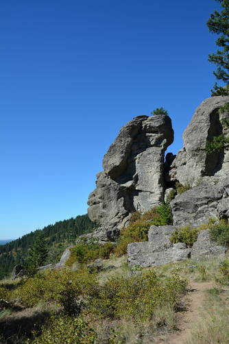
Hazards
Seasons
All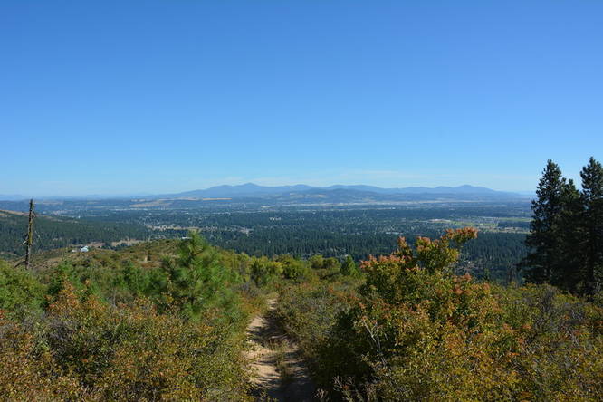
1 Trip Report


Helpful Links
Find Hiking Trails Near Me:


Before you leave...
MyHikes is an indie web platform aimed to make exploring public trails easier for everyone. The site has no investors and is owned and operated by one person, Dave Miller (Founder & Admin). As the Founder, main contributor, and doer-of-all-things for MyHikes, I share my trips with over-detailed write-ups for fun on a volunteer basis and I believe that public trail information should be available to everyone.
It takes a lot of time 🕦, money 💰, and effort (including espresso shots ☕) to run MyHikes, including hiking , mapping , writing , and publishing new trails with high-quality content... along with building new features, moderating, site maintainance, and app development for iOS and Android . I simply ask that if you find MyHikes' trail guides helpful to please consider becoming a Supporter to help keep the site, iOS, and Android apps available to everyone.
Supporters unlock website and in-app perks with a one-time payment of $25 (you renew) 😎👍. Or you can simply make a Donation of your choice without a MyHikes user account. Otherwise, telling your friends about MyHikes is the next-best thing - both quick and free 🎉
Thanks for visiting MyHikes and have a great hike!️

Dave Miller
MyHikes Founder & Admin

