Flume Gully Falls
Distance:
0.2 Miles / 0.3 kmType:
Out-and-BackDifficulty:
EasyTime to Hike:
~6 minutesFeatures:
Surface Type:
DirtLoading...
Loading...
Flume Gully Falls at The Gully Preserve in Wayland, New York is an easy 0.2-mile out-and-back hike that leads to a series of waterfalls that cascades down a rock flume gorge. Flume Gully Falls.
Waterfalls
This hike leads to a multi-tiered waterfall named Flume Gully Falls. The largest cascade is about 10-feet tall with lower cascades of about 5+ feet tall that shoot down a naturally carved out rock flume. There are many other waterfalls upstream to the last waterfall in this hike, but they're all inaccessible due to the steep surrounding gorge terrain. Most of them are visible, obstructed, via the White Trail at The Gully Preserve.
Hike Description
This hike begins along the White Trail at The Gully Preserve, almost immediately to the right-hand side of the trail once you hop on the White Trail. Hikers will head down a small hillside and then meander through the forest, adjacent to Little Mill Creek, as this unofficial trail makes its way over to the waterfalls.
Around mile 0.1, hikers will locate the rock flume and its waterfalls as they cascade down the creek's bedrock. The lower portion of the waterfalls is fairly easy to navigate as the bedrock surrounding the flume is mostly flat; however, you must be careful if you choose to make your way up the creek further. Hikers will have to carefully walk along the flat sections of shale bedrock to make their way up the waterfalls until they reach an inaccessible point where you can't hike any further. Here, you get a beautiful view of a ~10-foot waterfall located upstream, with a nice pool of water that sits calmly between the large waterfall's lower slide and the rock flume below. This is a great spot for fishing as well.
Parking
Hikers will find two very small parking turnouts just
west of the trailhead along Whiteman Gully Road. The turnouts are large
enough to fit about 3 vehicles each, max.
Pets
Dogs are allowed only if leashed and cleaned up after.
Warning
Slippery rocks / flume: In order to explore this waterfall, hikers must walk adjacent to fast moving water that rockets through a bedrock rock flume. Watch every step as you could get seriously injured if you accidentally fall in.
-
Parking
42.557082, -77.652072 -
Main Trailhead
42.557284, -77.651529 -
Flume Gulley Falls (multi-tiered)
42.558354, -77.651434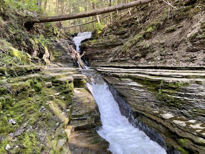
Hazards
Seasons
All
2 Trip Reports


Before you leave...
MyHikes is an indie web platform aimed to make exploring public trails easier for everyone. The site has no investors and is owned and operated by one person, Dave Miller (Founder & Admin). As the Founder, main contributor, and doer-of-all-things for MyHikes, I share my trips with over-detailed write-ups for fun on a volunteer basis and I believe that public trail information should be available to everyone.
It takes a lot of time 🕦, money 💰, and effort (including espresso shots ☕) to run MyHikes, including hiking , mapping , writing , and publishing new trails with high-quality content... along with building new features, moderating, site maintainance, and app development for iOS and Android . I simply ask that if you find MyHikes' trail guides helpful to please consider becoming a Supporter to help keep the site, iOS, and Android apps available to everyone.
Supporters unlock website and in-app perks with a one-time payment of $25 (you renew) 😎👍. Or you can simply make a Donation of your choice without a MyHikes user account. Otherwise, telling your friends about MyHikes is the next-best thing - both quick and free 🎉
Thanks for visiting MyHikes and have a great hike!️

Dave Miller
MyHikes Founder & Admin

