The Hogback Vista
Distance:
0.1 Miles / 0.2 kmType:
Out-and-BackDifficulty:
EasyTime to Hike:
~5 minutesFeatures:
Surface Type:
DirtLoading...
Loading...
The Hogback Vista at Grand Staircase-Escalante National Monument near
Boulder, Utah is an easy 0.1-mile out-and-back walk that leads to a stunning overlook from a mountain ridge named The Hogback.
This is not a hike but
rather a short roadside stop and walk along UT-12 from the top of a mountain ridge. The road follows the twisted and windy road over this sharp mountain ridge and provides absolutely stunning views to motorists along the way. It's well-worth the stop at The Hogback Vista to take in more of these views, especially to peer down into the valley below where you'll find more amazing rock formations and canyons of the Grand Staircase-Escalante National Monument. Before you leave, don't forget to check out the view from the opposite side of the road as well - including looking back at UT-12 to see it twist along the mountain ridge. Watch out for traffic!
Universal Access
This vista point does not have a universally-accessible pathway; however, due to the steep elevation grade of The Hogback (mountain ridge), visitors do not necessarily need to leave their vehicle to enjoy this stunning overlook.
Parking
Visitors
will find a large dirt parking turnout at the coordinates provided.
Pets
Dogs are allowed if leashed and must be cleaned up after.
-
Parking
37.839711, -111.421531 -
Main Trailhead
37.839711, -111.421531 -
The Hogback Vista (road view)
37.839547, -111.421439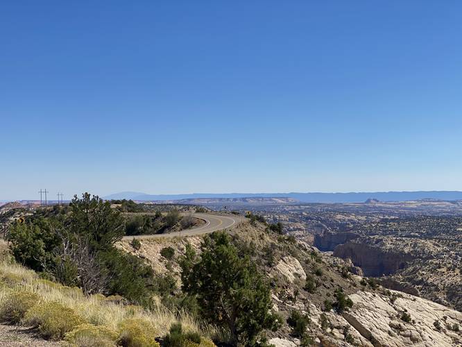
Hazards
Seasons
All
2 Trip Reports


Helpful Links
Find Hiking Trails Near Me:


Before you leave...
MyHikes is an indie web platform aimed to make exploring public trails easier for everyone. The site has no investors and is owned and operated by one person, Dave Miller (Founder & Admin). As the Founder, main contributor, and doer-of-all-things for MyHikes, I share my trips with over-detailed write-ups for fun on a volunteer basis and I believe that public trail information should be available to everyone.
It takes a lot of time 🕦, money 💰, and effort (including espresso shots ☕) to run MyHikes, including hiking , mapping , writing , and publishing new trails with high-quality content... along with building new features, moderating, site maintainance, and app development for iOS and Android . I simply ask that if you find MyHikes' trail guides helpful to please consider becoming a Supporter to help keep the site, iOS, and Android apps available to everyone.
Supporters unlock website and in-app perks with a one-time payment of $25 (you renew) 😎👍. Or you can simply make a Donation of your choice without a MyHikes user account. Otherwise, telling your friends about MyHikes is the next-best thing - both quick and free 🎉
Thanks for visiting MyHikes and have a great hike!️

Dave Miller
MyHikes Founder & Admin

