South Overlook Trail
Distance:
0.1 Miles / 0.2 kmType:
Out-and-BackDifficulty:
EasyTime to Hike:
~5 minutesFeatures:
Surface Type:
DirtLoading...
Loading...
The South Overlook Trail at Cowanesque Lake Recreation Area near
Lawrenceville, Pennsylvania is an easy 0.1-mile out-and-back trail that
leads down to an old defunct parking area on the south side of the lake.
This recording, not technically a trail, leads down what used to be the South Overlook at the lake. The parking lot has been in disrepair for quite a while and thus the gate that closes off the lot is currently closed, as of October 2019.
This recording heads into the parking area for a short walk to see what used to exist here, but there's really not much to see other than a view of the lake from the southern shore.
History
Congress
authorized the construction of Cowanesque Lake, a U.S. Army Corps of
Engineers project, to reduce the impact of storms such as Hurricane
Agnes in 1972. The primary goal of the project was to reduce risk of
flooding to communities in southern New York and northern Pennsylvania.
Since the project began, the dam has saved millions of dollars in flood
damage and continues to protect surrounding communities to this day.
Parking
Hikers can find parking at the coordinates provided - directly in front of the gate to the lot. Do not block the gate. There's enough room for a few cars to pull off of the road and not block the gate.
Pets
Dogs are allowed if leashed and their waste must be carried out by the hiker. Beware of broken glass and things of that nature in the old parking lot.
Hazards
Seasons
All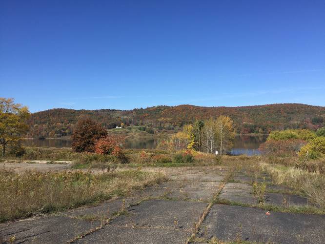
1 Trip Report


Helpful Links
Find Hiking Trails Near Me:


Before you leave...
MyHikes is an indie web platform aimed to make exploring public trails easier for everyone. The site has no investors and is owned and operated by one person, Dave Miller (Founder & Admin). As the Founder, main contributor, and doer-of-all-things for MyHikes, I share my trips with over-detailed write-ups for fun on a volunteer basis and I believe that public trail information should be available to everyone.
It takes a lot of time 🕦, money 💰, and effort (including espresso shots ☕) to run MyHikes, including hiking , mapping , writing , and publishing new trails with high-quality content... along with building new features, moderating, site maintainance, and app development for iOS and Android . I simply ask that if you find MyHikes' trail guides helpful to please consider becoming a Supporter to help keep the site, iOS, and Android apps available to everyone.
Supporters unlock website and in-app perks with a one-time payment of $25 (you renew) 😎👍. Or you can simply make a Donation of your choice without a MyHikes user account. Otherwise, telling your friends about MyHikes is the next-best thing - both quick and free 🎉
Thanks for visiting MyHikes and have a great hike!️

Dave Miller
MyHikes Founder & Admin

