Simpson Reed Trail
Distance:
0.6 Miles / 1.0 kmType:
LoopDifficulty:
EasyTime to Hike:
~18 minutesFeatures:
Surface Type:
DirtLoading...
Loading...
The Simpson Reed Trail at Jedediah Smith Redwoods State Park in Crescent City, California is an easy 0.6-mile loop trail that features ancient Redwoods.
Some of the largest Redwoods I have ever seen, expect to see several varieties of animal and plant species, including redwoods, hemlocks, ferns, huckleberries, rough-skinned newts, red-legged frogs, and an array of fish and bugs.
Parking: Parking can be found at the coordinates provided; however, you must walk up the road a short distance to the trailhead.
Pets: Dogs are not allowed on trails at Jedediah Smith Redwoods State Park.
Hazards
Seasons
All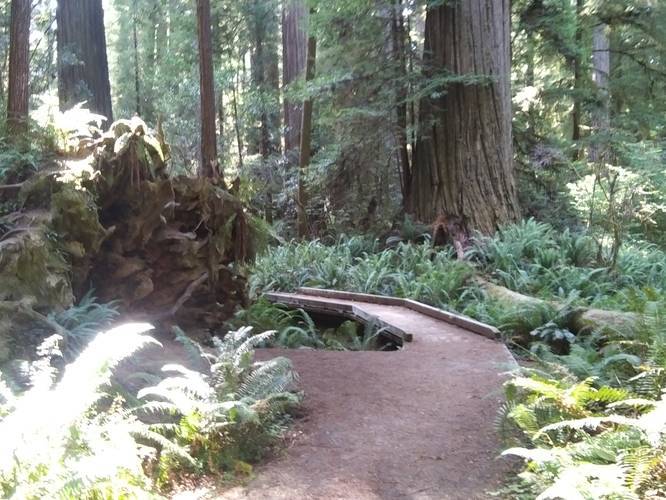
1 Trip Report


Helpful Links
Find Hiking Trails Near Me:


Before you leave...
MyHikes is an indie web platform aimed to make exploring public trails easier for everyone. The site has no investors and is owned and operated by one person, Dave Miller (Founder & Admin). As the Founder, main contributor, and doer-of-all-things for MyHikes, I share my trips with over-detailed write-ups for fun on a volunteer basis and I believe that public trail information should be available to everyone.
It takes a lot of time 🕦, money 💰, and effort (including espresso shots ☕) to run MyHikes, including hiking , mapping , writing , and publishing new trails with high-quality content... along with building new features, moderating, site maintainance, and app development for iOS and Android . I simply ask that if you find MyHikes' trail guides helpful to please consider becoming a Supporter to help keep the site, iOS, and Android apps available to everyone.
Supporters unlock website and in-app perks with a one-time payment of $25 (you renew) 😎👍. Or you can simply make a Donation of your choice without a MyHikes user account. Otherwise, telling your friends about MyHikes is the next-best thing - both quick and free 🎉
Thanks for visiting MyHikes and have a great hike!️

Dave Miller
MyHikes Founder & Admin

