Sandstone Canyon Loop Trail
Distance:
1.8 Miles / 2.9 kmType:
LoopDifficulty:
EasyTime to Hike:
~54 minutesFeatures:
Surface Type:
DirtLoading...
Loading...
The Sandstone Canyon Loop Trail at Spring Mountain Ranch State Park in Blue Diamond, Nevada is an easy 1.8-mile loop trail that passes through Sandstone Canyon with beautiful vistas along the way.
Trail Name: Sandstone Canyon Loop Trail
Trailhead Location: Spring Mountain Ranch State Park, Blue Diamond, NV
Allowed activities: Hiking, biking, horseback riding, birding, geocaching, picnicking with tables and grills available for use
Forbidden activities: no Littering, no motor vehicles, no shooting, no off trail hiking, do not remove: plants, animals, rocks or wood, no climbing trees, no camping.
Hours: Trails close one hour to the parks closing. The park is open daily and times vary by season:
June, July & August: 8 a.m. - 8 p.m.
September: 8 a.m. - 7 p.m.
October: 8 a.m. - 6 p.m.
November, December, January & February: 8 a.m. - 4:30 p.m.
March & April: 8 a.m. - 6 p.m.
May: 8 a.m. - 7 p.m.
Warning: Temperatures can vary wildly from below freezing in the winter to 100+ degrees in the summer. Winds can be gusting at times. Summertime visitors can be met with sudden thundershowers and flash floods. Please make sure to carry plenty of water with you.
Parking and fees: There is plenty of parking at the Park and there is an entrance fee. At the time of our visit the fee was $10.00 per vehicle or if you bike in, $2.00 per bike.
Pets: Dogs are allowed on the trails as long as they are leashed and waste is carried out with the hiker. Leashes must not exceed 6 feet in length.
Accessibility: This is not a hike for those with balance or mobility issues. This trail has many uneven surfaces with rocks to step around.
Sanitation: There are restrooms at the picnic area of the park. There are trash bins throughout the park and near picnic tables.
Trail information: There are several trail placards posted throughout the park at each trail head location. A copy of the trails can be downloaded or printed by following the link below:
http://parks.nv.gov/parks/spring-mountain-ranch
Scroll down the page and pick “trails/maps”. Alternatively you can click the Park Map link on this page.
Length and features: This is an easy 1.8 mile hike done as a loop. The trail surface is a mixture of dirt and sandstone. Sandstone Wash Creek runs through one section of the trail and will need to be crossed over using stepping stones. There is a slight incline after the stream crossing. There is a section of the trail that is fairly smooth and wide and appears to be an access road for the park officials; however most of the trail is neither wide nor flat but fairly obvious despite there no trail blaze markers. There are several signs along the way reminding hikers not to go off of the trail. Those signs are usually brown rectangles with white lettering. The views are simply spectacular and wild burros frequent the area.
Explore 9 trails near Blue Diamond, NVHazards
Seasons
All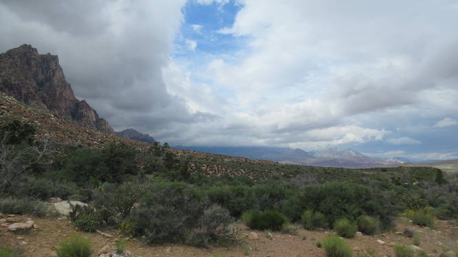
1 Trip Report


Helpful Links
Find Hiking Trails Near Me:


Before you leave...
MyHikes is an indie web platform aimed to make exploring public trails easier for everyone. The site has no investors and is owned and operated by one person, Dave Miller (Founder & Admin). As the Founder, main contributor, and doer-of-all-things for MyHikes, I share my trips with over-detailed write-ups for fun on a volunteer basis and I believe that public trail information should be available to everyone.
It takes a lot of time 🕦, money 💰, and effort (including espresso shots ☕) to run MyHikes, including hiking , mapping , writing , and publishing new trails with high-quality content... along with building new features, moderating, site maintainance, and app development for iOS and Android . I simply ask that if you find MyHikes' trail guides helpful to please consider becoming a Supporter to help keep the site, iOS, and Android apps available to everyone.
Supporters unlock website and in-app perks with a one-time payment of $25 (you renew) 😎👍. Or you can simply make a Donation of your choice without a MyHikes user account. Otherwise, telling your friends about MyHikes is the next-best thing - both quick and free 🎉
Thanks for visiting MyHikes and have a great hike!️

Dave Miller
MyHikes Founder & Admin

