Palmer Wildlife Management Area Yellow Dot Trail
Distance:
1.2 Miles / 1.9 kmType:
Out-and-BackDifficulty:
HardTime to Hike:
~36 minutesFeatures:
Surface Type:
DirtLoading...
Loading...
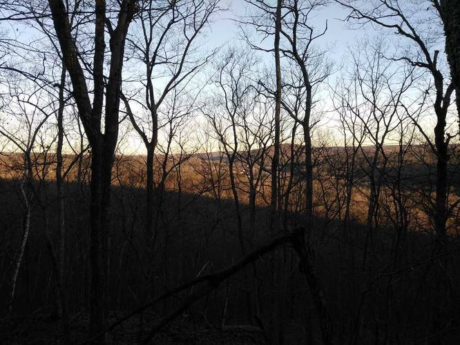
The Yellow Dot Trail at the Palmer Wildlife Management Area in Palmer, Massachusetts is a difficult 1.2 mile out-and-back hike on Route 67 near the Warren border. The trail is a bit of mess with plenty of fallen trees and it's not marked very well, so navigating your way back can be tricky. The peak, where this GPS track turns around, provides some views of Warren, Massachusetts through the trees when the leaves are not on them; however, there's likely nothing to see from this point when the leaves are on the trees. In the winter, there may be some ice-flow on a nearby rockface along the hike too. Dogs are allowed here.
Hazards
Seasons
AllBlaze Dot
1 Trip Report


Helpful Links
Find Hiking Trails Near Me:


")


Before you leave...
MyHikes is an indie web platform aimed to make exploring public trails easier for everyone. The site has no investors and is owned and operated by one person, Dave Miller (Founder & Admin). As the Founder, main contributor, and doer-of-all-things for MyHikes, I share my trips with over-detailed write-ups for fun on a volunteer basis and I believe that public trail information should be available to everyone.
It takes a lot of time 🕦, money 💰, and effort (including espresso shots ☕) to run MyHikes, including hiking , mapping , writing , and publishing new trails with high-quality content... along with building new features, moderating, site maintainance, and app development for iOS and Android . I simply ask that if you find MyHikes' trail guides helpful to please consider becoming a Supporter to help keep the site, iOS, and Android apps available to everyone.
Supporters unlock website and in-app perks with a one-time payment of $25 (you renew) 😎👍. Or you can simply make a Donation of your choice without a MyHikes user account. Otherwise, telling your friends about MyHikes is the next-best thing - both quick and free 🎉
Thanks for visiting MyHikes and have a great hike!️

Dave Miller
MyHikes Founder & Admin

