Old Robe Trail
Distance:
3.6 Miles / 5.8 kmType:
Out-and-BackDifficulty:
ModerateTime to Hike:
1 hour, ~48 minutesFeatures:
Surface Type:
DirtLoading...
Loading...
The Old Robe Trail at the Robe Canyon Historic Trail Park near Granite Falls, Washington is a moderate 3.6-mile out-and-back trail that follows a historic railway along the Stillaguamish River.
Hike Description
Over a century ago, the trail was used to transport gold and silver through the Cascade Mountains. Today, it's a nice and easy nature walk, featuring tunnels and the aquamarine rapids of the Stillaguamish.
The trail starts down a hillside through a series of switchbacks. This initial descent (and the eventual return up the hill) is virtually the only elevation change on the hike. At the bottom of the slope, the surrounding environment takes on an almost swamp-like feel, with moss covered trees growing out of muddy standing water.
At around mile 0.5 is the Stillaguamish and first signs of Old Robe's historic past, with massive railroad ties supporting the path. The trail follows the river and just as the scenery is becoming impressive, a rockslide and sign mark the turnaround point of the out-and-back hike. While it is not advisable, some hikers choose to ignore the warnings and forge on to explore tunnels and more rapids.
Parking
Hikers will find a small parking at the coordinates provided.
Pets
Dogs are allowed if leashed and their waste should be carried out by the hiker.
Warnings
There are closures along this trail near tunnels - this is for a reason. Please follow the rules and do not venture beyond the closure signs unless you have the proper authorization.
Trail and photos provided in partnership by hike.io.
Seasons
All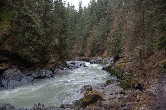
1 Trip Report


Helpful Links
Find Hiking Trails Near Me:


Before you leave...
MyHikes is an indie web platform aimed to make exploring public trails easier for everyone. The site has no investors and is owned and operated by one person, Dave Miller (Founder & Admin). As the Founder, main contributor, and doer-of-all-things for MyHikes, I share my trips with over-detailed write-ups for fun on a volunteer basis and I believe that public trail information should be available to everyone.
It takes a lot of time 🕦, money 💰, and effort (including espresso shots ☕) to run MyHikes, including hiking , mapping , writing , and publishing new trails with high-quality content... along with building new features, moderating, site maintainance, and app development for iOS and Android . I simply ask that if you find MyHikes' trail guides helpful to please consider becoming a Supporter to help keep the site, iOS, and Android apps available to everyone.
Supporters unlock website and in-app perks with a one-time payment of $25 (you renew) 😎👍. Or you can simply make a Donation of your choice without a MyHikes user account. Otherwise, telling your friends about MyHikes is the next-best thing - both quick and free 🎉
Thanks for visiting MyHikes and have a great hike!️

Dave Miller
MyHikes Founder & Admin

