Lee Fire Tower Site
Distance:
0 Miles / 0 kmType:
Out-and-BackDifficulty:
EasyTime to Hike:
~5 minutesFeatures:
Surface Type:
DirtLoading...
Loading...
The Lee Fire Tower Site at Tioga State Forest near Leetonia, Pennsylvania is a quick and easy walk to an abandoned fire tower location and features an old survey marker.
This is not a hike but rather a short road-side stop that requires very little walking to reach the site where the Lee Fire Tower once stood. Note that the fire tower is gone and has been for decades, nothing is left other than the survey marker and some mostly-hidden concrete pillars. Hunting old U.S. Geological Survey or U.S. Coast and Geodetic Survey markers / summit markers is a weird hobby of mine, so I'm now able to say I bagged this marker too. If you're looking to find the Lee Fire Tower survey marker start at the open parking area at the parking coordinates provided and face west. Walk to the evergreen trees on the opposite side of the road and look for an opening in the trees (looking up helps locate the blank space easier), then look down - there should be a bed of ferns or dead ferns, depending on the season. In the middle of that open fern patch is the old U.S. Coast & Geodetic Survey marker. Note that the open fern patch is pretty small - no larger than 10-feet by 10-feet or so as of July 2023. The survey marker located here, dated 1933, was installed to mark the Lee Fire Tower. Upon this trip, I did not spend time searching for the old concrete fire tower pillars; however, the survey markers were generally placed below the fire towers, hence this is the old Lee Fire Tower site.
Parking
Visitors will find a parking turnout on the east side of the forest road at the coordinates provided and is large enough to fit a couple vehicles.
Pets
Dogs are allowed if leashed and must be cleaned up after.
-
Parking
41.623418, -77.548417 -
Main Trailhead
41.623426, -77.548406 -
Lee Fire Tower U.S. Coast & Geodetic Survey marker (1933)
41.623397, -77.548661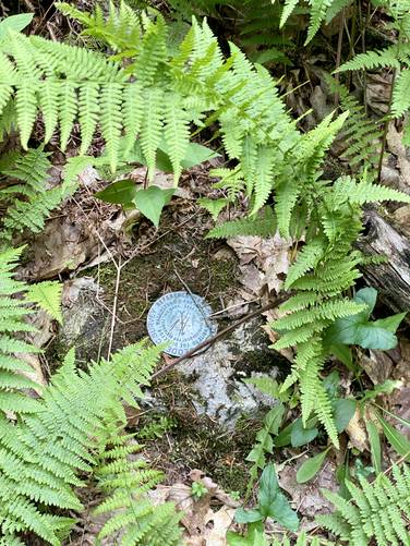
Hazards
Seasons
Spring, Summer, Fall
2 Trip Reports


Helpful Links
Find Hiking Trails Near Me:


Before you leave...
MyHikes is an indie web platform aimed to make exploring public trails easier for everyone. The site has no investors and is owned and operated by one person, Dave Miller (Founder & Admin). As the Founder, main contributor, and doer-of-all-things for MyHikes, I share my trips with over-detailed write-ups for fun on a volunteer basis and I believe that public trail information should be available to everyone.
It takes a lot of time 🕦, money 💰, and effort (including espresso shots ☕) to run MyHikes, including hiking , mapping , writing , and publishing new trails with high-quality content... along with building new features, moderating, site maintainance, and app development for iOS and Android . I simply ask that if you find MyHikes' trail guides helpful to please consider becoming a Supporter to help keep the site, iOS, and Android apps available to everyone.
Supporters unlock website and in-app perks with a one-time payment of $25 (you renew) 😎👍. Or you can simply make a Donation of your choice without a MyHikes user account. Otherwise, telling your friends about MyHikes is the next-best thing - both quick and free 🎉
Thanks for visiting MyHikes and have a great hike!️

Dave Miller
MyHikes Founder & Admin

