Kellogg Mountain Crags
Distance:
0.2 Miles / 0.3 kmType:
LoopDifficulty:
EasyTime to Hike:
~6 minutesFeatures:
Surface Type:
DirtLoading...
Loading...
Kellogg Mountain Crags at State Game Lands 36 near Monroe, Pennsylvania is an easy 0.2-mile off-trail hike that leads to neat rock outcroppings that include rock overhangs, crags, and mini rock gorges.
Getting to SGL 36 (Seasonal Road)
Note that the road that
leads up to Kellogg Mountain, within State Game Lands 36 (SGL 36) is
closed outside of the hunting season. Hunting season, and thus gate
openings and closures, change each year; however, during the 2023 - 2024
hunting season, the road's gates were opened mid-September and close
January 21. The road will be re-opened in 2024 from April 25, 2024 to
June 2, 2024. You can check the status of seasonal SGL roads here.
Hike Description
This hike begins near the trailhead and parking coordinates provided and heads into the woods off-trail, heading south from the road. The off-trail hike is pretty annoying at first as it leads through a very-rocky terrain where the rocks are covered by forest debris like leaves and such. Due to this, go extra slow to ensure proper footing and to prevent any injuries. Shortly after the annoying rock terrain, hikers will reach a ~15-foot tall rock ledge with a cave-like overhang underneath. The cave is no deeper than 5 or 6-feet, but runs a good length of the ledge at about 30-feet long. If you hike further south, you'll find a short rock crag or "gorge" that you can hike through. This track scrambles up the west side of the rock gorge to find yet another rock gorge / crag. You can hike down and into the crags, to pass through a fairly narrow section of the rocks where you'll find moss and lichen within this neat rock-scape scenery.
Once done exploring, you can hike out the same way you hiked in or you can attempt to head uphill slightly, as this track does, to ultimately head back downhill to reach the road. Be careful of the hidden rocks within the leaves on your way out.
Parking
Hikers will find parking at a turnout at the coordinates provided, located along the entrance road to the summit of Kellogg Mountain within SGL 36 -- only when the entrance road gates are
opened. The road gates are opened between the months of mid-September to
late January each year for hunting. Please check the Pennsylvania State
Game Lands Commission for more details before heading out to ensure the
road is open.
Warnings
Hunting: This hike leads through State Game
Lands and due to the fact that this area is accessible during hunting
season, it's smart to wear blaze orange while hiking here. During
hunting season, it's against the law in Pennsylvania to hike through
State Game Lands without blaze orange, so remember to bring it with you.
Hidden rocks: This off-trail hike leads through areas of large hidden rocks, covered by leaves. These can be super tricky to traverse over, never mind not hurting yourself in the process. Be extra careful when hiking out to the rock outcroppings.
Timber Rattlesnakes:
This trail leads through exposed bedrock mountain terrain that's
perfect for Timber Rattlesnake basking and sun bathing. While a bit more
rare in this part of the state, be on the lookout for rattlers and give
any you find plenty of space.
-
Parking
41.682194, -76.483106 -
Main Trailhead
41.682262, -76.48308 -
Cave-like overhang
41.681861, -76.483147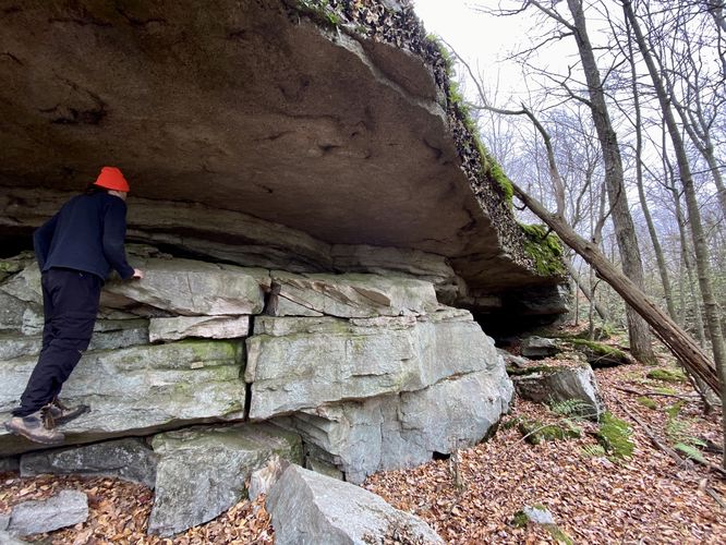
-
Inside the first rock crags
41.681542, -76.483292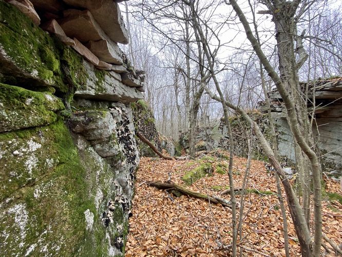
-
Inside the second rock crags
41.681542, -76.483314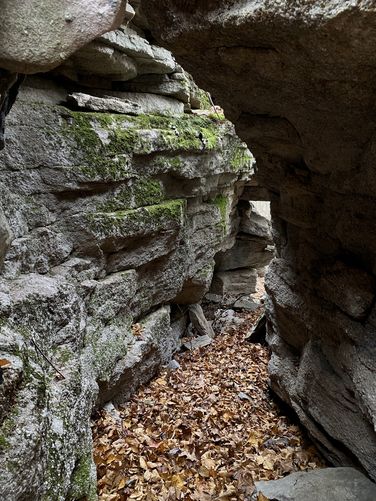
Hazards
Seasons
All
1 Trip Report


Before you leave...
MyHikes is an indie web platform aimed to make exploring public trails easier for everyone. The site has no investors and is owned and operated by one person, Dave Miller (Founder & Admin). As the Founder, main contributor, and doer-of-all-things for MyHikes, I share my trips with over-detailed write-ups for fun on a volunteer basis and I believe that public trail information should be available to everyone.
It takes a lot of time 🕦, money 💰, and effort (including espresso shots ☕) to run MyHikes, including hiking , mapping , writing , and publishing new trails with high-quality content... along with building new features, moderating, site maintainance, and app development for iOS and Android . I simply ask that if you find MyHikes' trail guides helpful to please consider becoming a Supporter to help keep the site, iOS, and Android apps available to everyone.
Supporters unlock website and in-app perks with a one-time payment of $25 (you renew) 😎👍. Or you can simply make a Donation of your choice without a MyHikes user account. Otherwise, telling your friends about MyHikes is the next-best thing - both quick and free 🎉
Thanks for visiting MyHikes and have a great hike!️

Dave Miller
MyHikes Founder & Admin

