Jewell Falls
Distance:
0.4 Miles / 0.6 kmType:
Out-and-BackDifficulty:
EasyTime to Hike:
~12 minutesFeatures:
Surface Type:
DirtLoading...
Loading...
Jewell Falls at Fore River Sanctuary in Portland, Maine is an easy 0.4-mile out-and-back hike that leads to the 30-foot tall multi-tiered waterfall known as Jewell Falls.
Hike Description
This short hike begins at the parking lot for Fore River Sanctuary, located at the end of Hill Crest Ave in Portland. Hikers will find the trailhead located on the western side of the road. The trail follows a dirt path that leads into the Fore River Sanctuary as it passes neighboring private properties, so please be respectful of the private land owners and stay on-trail at all times.
The trail follows white blazes that lead out to a wooden footbridge that crosses the top of Jewell Falls. Hikers will follow the stone staircase down the hill to reach the base of the waterfall. From the bottom, hikers can enjoy Jewell Falls as it cascades down a series of bedrock slopes forming the scenic waterfall.
After enjoying Jewell Falls, hikers can choose to explore more of the Fore River Sanctuary on foot or head out along this out-and-back path.
Parking
Hikers will find parking at the coordinates provided - at the end of Hill Crest Ave in Portland. Be mindful of the private land owners - be quiet, don't stick around for long, and stay on-trail at all times near the trailhead.
Pets
Dogs are allowed only if leashed and must be cleaned up after.
-
Parking
43.671871, -70.316566 -
Main Trailhead
43.671898, -70.316693 -
Jewell Falls, 30-feet tall
43.670479, -70.318227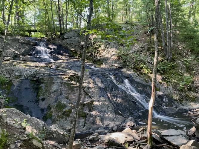
Hazards
Seasons
AllBlaze Color
2 Trip Reports


Helpful Links
Find Hiking Trails Near Me:


Before you leave...
MyHikes is an indie web platform aimed to make exploring public trails easier for everyone. The site has no investors and is owned and operated by one person, Dave Miller (Founder & Admin). As the Founder, main contributor, and doer-of-all-things for MyHikes, I share my trips with over-detailed write-ups for fun on a volunteer basis and I believe that public trail information should be available to everyone.
It takes a lot of time 🕦, money 💰, and effort (including espresso shots ☕) to run MyHikes, including hiking , mapping , writing , and publishing new trails with high-quality content... along with building new features, moderating, site maintainance, and app development for iOS and Android . I simply ask that if you find MyHikes' trail guides helpful to please consider becoming a Supporter to help keep the site, iOS, and Android apps available to everyone.
Supporters unlock website and in-app perks with a one-time payment of $25 (you renew) 😎👍. Or you can simply make a Donation of your choice without a MyHikes user account. Otherwise, telling your friends about MyHikes is the next-best thing - both quick and free 🎉
Thanks for visiting MyHikes and have a great hike!️

Dave Miller
MyHikes Founder & Admin

