Hell's Hollow Trail
Distance:
1.2 Miles / 1.9 kmType:
Out-and-BackDifficulty:
EasyTime to Hike:
~36 minutesFeatures:
Surface Type:
DirtLoading...
Loading...
Hell's Hollow Trail at McConnell's Mill State Park in Ellwood City, Pennsylvania is an easy 1.2 mile out-and-back hike down to Hell's Hollow Falls and back. Hell's Hollow Falls is about 15 feet tall and about 20 feet wide, but cascades down the hill for a further distance before reaching the true falls. The hike to Hell's Hollow Falls is short and flat, making this a quick day hike; however, getting down to the falls is not wheelchair accessible. Just before you reach the bottom of the falls, the trail starts heading downhill to a staircase and the trail can be slippery, because the trail is mostly rocky.
Follow the staircase down to the creek and use the large rocks in the creek to cross it. On the other side of the creek you can get an excellent view of Hell's Hollow Falls and the creek that cascades down the large rock formation just before the falls.
This is one of the best trails in McConnell's Mill State Park and is a moderately-trafficked trail. This trail is much more popular on weekends and there's often at least one group of people at the falls at all times on the weekends; however, you can certainly plan a secluded visit to Hell's Hollow Falls during the middle of the week.
-
Parking
40.931389, -80.240067 -
Main Trailhead
40.931349, -80.239845 -
Hell's Hollow Falls
40.929692, -80.23175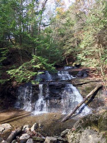
-
Hell's Hollow Falls
40.929622, -80.231681
Hazards
Season
Summer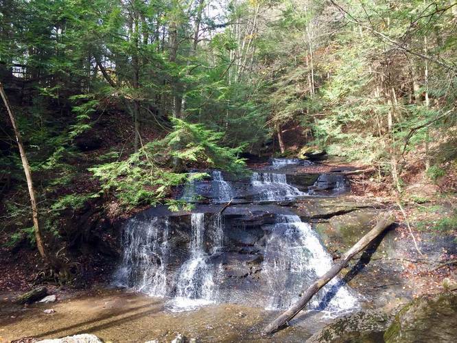
5 Trip Reports


Helpful Links
Find Hiking Trails Near Me:


Before you leave...
MyHikes is an indie web platform aimed to make exploring public trails easier for everyone. The site has no investors and is owned and operated by one person, Dave Miller (Founder & Admin). As the Founder, main contributor, and doer-of-all-things for MyHikes, I share my trips with over-detailed write-ups for fun on a volunteer basis and I believe that public trail information should be available to everyone.
It takes a lot of time 🕦, money 💰, and effort (including espresso shots ☕) to run MyHikes, including hiking , mapping , writing , and publishing new trails with high-quality content... along with building new features, moderating, site maintainance, and app development for iOS and Android . I simply ask that if you find MyHikes' trail guides helpful to please consider becoming a Supporter to help keep the site, iOS, and Android apps available to everyone.
Supporters unlock website and in-app perks with a one-time payment of $25 (you renew) 😎👍. Or you can simply make a Donation of your choice without a MyHikes user account. Otherwise, telling your friends about MyHikes is the next-best thing - both quick and free 🎉
Thanks for visiting MyHikes and have a great hike!️

Dave Miller
MyHikes Founder & Admin

