Hawk Falls Trail
Distance:
1.1 Miles / 1.8 kmType:
Out-and-BackDifficulty:
EasyTime to Hike:
~33 minutesFeatures:
Surface Type:
DirtLoading...
Loading...
Hawk Falls Trail at Hickory Run State Park in Kidder Township, Pennsylvania is an easy and super popular 1.1-mile out-and-back hike that leads to the 30-foot tall waterfall, Hawk Falls.
Popularity
This hike is one of the most-popular day hikes in Pennsylvania likely due to its proximity to the cities and I-476. Expect to see other people on this trail unless you show up extremely early in the morning or very late in the day.
Hike Description
This hike begins at the main trailhead for the Hawk Falls Trail, located along PA-534 just a few-hundred feet East of I-476. Hikers will start at one of the large parking lots East of the trailhead, which will require a short bit of road walking to reach the actual trail. Once on the trail, the Hawk Falls Trail leads downhill for most of the hike in. Along the way are old rhododendrons that stretch high above the trail and make for neat scenery year-round. Hikers will cross a footbridge that spans Hawk Run then will continue their hike through the forest until they reach a trail junction around mile 0.45.
Right-Hand Turn - Mile 0.45
At mile 0.45, hikers will find signs for "Hawk Falls -->" take a right-hand turn here to follow the yellow blazes along a flat trail. This flat trail follows along side Mud Run as it makes its way back to Hawk Run.
Hawk Falls - Mile 0.55
Around mile 0.55, the trail will turn northward again where you'll find Hawk Falls cascading down the creek's bedrock. Hawk Falls is about 30-feet tall and cascades in a fantail shape with the top being skinnier than the bottom. There are numerous viewing points for Hawk Falls but the best are out in the creek on top of the rocks that are scattered -- watch your step if you attempt to hike into the creek for a better shot. Due to the popularity of this waterfall, you might have to wait around for a bit to get a decent spot to take a photo or to find a spot to sit and relax.
The hike out from Hawk Falls is another 0.55 miles but it's all uphill. Due to the easy elevation grade, the hike out should be considered easy for most hikers. Some may find it slightly more difficult, and hence might be a moderate hike instead.
Parking
Hikers will find two large parking lots at the coordinates provided -- located on the North and South sides of PA-534. The parking lots are large enough to fit several dozen vehicles.
Pets
Dogs are allowed only if leashed and must be cleaned up after.
Prohibited
Swimming, climbing, jumping, wading, and picnicking are all prohibited. Please respect the rules.
-
Parking
41.010745, -75.634119 -
Main Trailhead
41.010307, -75.634634 -
Hawk Falls approx. 30-feet tall
41.005931, -75.633842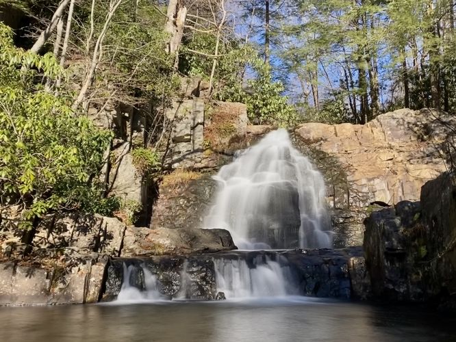
Hazards
Seasons
AllBlaze Color

2 Trip Reports


Helpful Links
Find Hiking Trails Near Me:


Before you leave...
MyHikes is an indie web platform aimed to make exploring public trails easier for everyone. The site has no investors and is owned and operated by one person, Dave Miller (Founder & Admin). As the Founder, main contributor, and doer-of-all-things for MyHikes, I share my trips with over-detailed write-ups for fun on a volunteer basis and I believe that public trail information should be available to everyone.
It takes a lot of time 🕦, money 💰, and effort (including espresso shots ☕) to run MyHikes, including hiking , mapping , writing , and publishing new trails with high-quality content... along with building new features, moderating, site maintainance, and app development for iOS and Android . I simply ask that if you find MyHikes' trail guides helpful to please consider becoming a Supporter to help keep the site, iOS, and Android apps available to everyone.
Supporters unlock website and in-app perks with a one-time payment of $25 (you renew) 😎👍. Or you can simply make a Donation of your choice without a MyHikes user account. Otherwise, telling your friends about MyHikes is the next-best thing - both quick and free 🎉
Thanks for visiting MyHikes and have a great hike!️

Dave Miller
MyHikes Founder & Admin

