Dragon's Back Trail
Distance:
3.8 Miles / 6.1 kmType:
Out-and-BackDifficulty:
ModerateTime to Hike:
1 hour, ~54 minutesFeatures:
Surface Type:
DirtLoading...
Loading...
The Dragon's Back Trail at Tiadaghton State Forest near Slate Run, Pennsylvania is a moderate 3.8-mile out-and-back trail that runs atop a mountain ridge featuring a stunning vista of Slate Run and Pine Creek, a fire burn scar, and also connects the Golden Eagle Trail to the Quarry Mountain Trail.
Signage Note
As of August 2021, there were no trailhead signs at either terminus for the Dragon's Back Trail, which can make finding the start / end of this trail tricky unless you have a map and know what you're looking for.
Hike Description
This track begins at the end of the Quarry Mountain Trail in the state forest and follows the yellow blazes of the Dragon's Back Trail to the Golden Eagle Trail. Hikers will first need to hike in on the Quarry Mountain Trail to reach this trail - which is a difficult 800+ foot climb. The highlight of this hike is the beautiful vista point high above Slate Run, which gives hikers a great place to rest and take in the views, making the climb up to this mountain ridge well worth the effort.
Starting at the Quarry Mountain Trail, the Dragon's Back Trail begins by sloping down and out of a "saddle" at the top of the mountain ridge - making the start of this trail a bit annoying after just climbing 800-1,000 feet (depending if you summit Quarry Mountain) to reach the trailhead.
After the initial saddle hiking down and back up, the trail levels out a bit before making more gradual climbs to reach the only unobstructed vista along the trail.
Slate Run Vista
At mile 0.35, hikers will reach the Slate Run Vista which has a stunning view of Pine Creek and the surrounding mountains. Here, hikers will want to take a break to take in the views before exploring the rest of the Dragon's Back Trail - as there are no other sweeping views along the trail until you hike back to this vista point.
Fire Burn Scar Obstructed View
After taking in the views at the Slate Run Vista, hikers will continue along the Dragon's Back Trail to reach another point-of-interest along the trail - a fire burn scar with an obstructed view between what appear to be red pine trees, around mile 0.73. This section of the hike is really interesting because as of August 2021, hikers can find evidence of burn marks on the trees, plenty of blueberry bushes growing on the forest floor, along with a thin line of red pines obstructing the view of the neighboring mountains - all clear signs of a forest fire. I'm not sure if this section of forest was deliberately set on fire for a controlled burn or if it was from natural causes. Either way, it's the only section of the trail that I felt was really worthy of exploring beyond the Slate Run Vista.
After stopping at the fire burn scar area, the trail becomes fairly boring from here on out as it's mostly a test of how much energy you want to spend. Either way, the hike to reach the Golden Eagle Trail is not very difficult, but the Dragon's Back Trail does make several hill climbs before finally descending to the Golden Eagle Trail.
Wide Grassy Trail
Around mile 1.5, hikers will reach a wide grassy section of the trail. Here, it's not much further to reach the Golden Eagle Trail, but this section is mostly in the sun and is about 1-mile out-and-back to complete. If you don't care much about descnding to re-ascend, you can skip this part and stick to the woodland area of the Dragon's Back Trail to stay out of the heat - unless you're planning to continue further onto the Golden Eagle Trail or other trails in the area.
Hiking Out
The hike from the Golden Eagle Trail back to the Quarry Mountain Trail is much easier, as most of the hiking is downhill. Hikers get the pleasure of stopping at the Slate Run Vista one more time, which again, makes a great place to stop - especially before starting the descent of the Quarry Mountain Trail.
Location
This trail exists within both Tiadaghton State Forest and State Game Lands 68. The largest section of this trail, located just north the fire burn area (as of Aug 2021), is located within State Game Lands 68.
Parking
Hikers can find parking near the coordinates
provided - both at the parking turnout along PA 414 next to the
trailhead and at the Tomb Flats parking area just across the street.
Pets
Dogs are allowed if leashed.
Backpacking and Camping
Backpacking
is technically allowed along this trail, but only within the state
forest section - as this trail does pass through some state game lands.
Please follow all rules when dispersed / primitive / backcountry
camping. Also note that as of August 2021, there were no predefined
campsites; however, there was a tiny fire ring at the vista - this did
not indicate an actual campsite.
Warning
Rattlesnakes:
This area is known for the Timber Rattlesnake. If you see one, give it
as much space as you can and continue hiking. With regard to dogs, it's
smart to keep them leashed at all times to reduce the chance of them
getting a snake bite as well.
Hunting: Since parts of this trail exist within State Game Lands 68, hikers may encounter hunters here. Wearing blaze orange is recommended.
Pine Creek Pinnacles (PCP20)
This hike is part of the Pine Creek Pinnacles hiking challenge. For more information, details, and FAQs, please visit our Pine Creek Pinnacles (PCP20) page.
-
Parking
41.457415, -77.509466 -
Main Trailhead
41.459369, -77.500183 -
Slate Run Vista - facing north with Slate Run, PA below
41.463978, -77.498244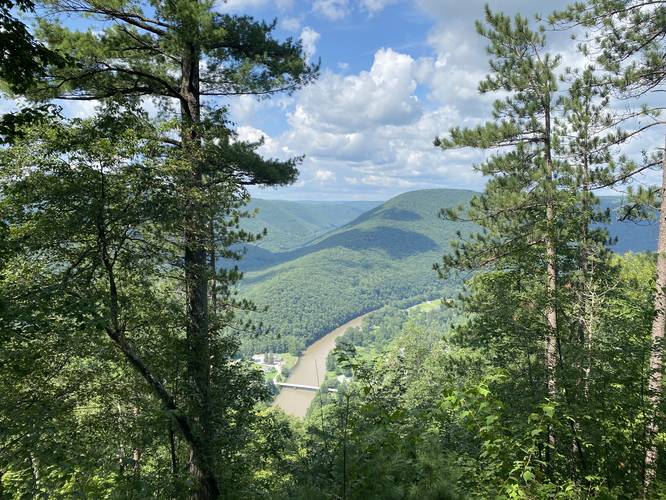
-
Burn scar vista area
41.467894, -77.494317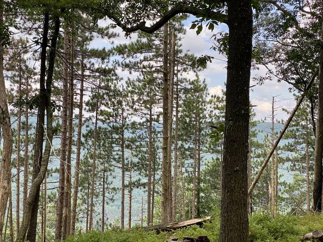
Hazards
Seasons
AllBlaze Color


8 Trip Reports


Helpful Links
Find Hiking Trails Near Me:


Before you leave...
MyHikes is an indie web platform aimed to make exploring public trails easier for everyone. The site has no investors and is owned and operated by one person, Dave Miller (Founder & Admin). As the Founder, main contributor, and doer-of-all-things for MyHikes, I share my trips with over-detailed write-ups for fun on a volunteer basis and I believe that public trail information should be available to everyone.
It takes a lot of time 🕦, money 💰, and effort (including espresso shots ☕) to run MyHikes, including hiking , mapping , writing , and publishing new trails with high-quality content... along with building new features, moderating, site maintainance, and app development for iOS and Android . I simply ask that if you find MyHikes' trail guides helpful to please consider becoming a Supporter to help keep the site, iOS, and Android apps available to everyone.
Supporters unlock website and in-app perks with a one-time payment of $25 (you renew) 😎👍. Or you can simply make a Donation of your choice without a MyHikes user account. Otherwise, telling your friends about MyHikes is the next-best thing - both quick and free 🎉
Thanks for visiting MyHikes and have a great hike!️

Dave Miller
MyHikes Founder & Admin

