Copperas Pond Trail
Distance:
1.2 Miles / 1.9 kmType:
Out-and-BackDifficulty:
ModerateTime to Hike:
~36 minutesFeatures:
Surface Type:
DirtLoading...
Loading...
The Copperas Pond Trail at Adirondack Park within the Sentinel Range Wilderness in Wilmington, New York is a moderate 1.2-mile out-and-back hike that leads to the shores of Copperas Pond and features views of the surrounding mountains.
Hike Description
This hike begins at the main trailhead at the coordinates provided, directly across the street from the parking turnout, and follows a steep and rocky trail as it ascends the base of the Sentinel Mountain Range. The trail climbs at a moderate to steep grade for about 0.3-miles before it begins to undulate uphill toward the pond. Hikers will reach a trail sign, just after mile 0.3, which points the way to Copperas Point - keeping right at the trail junction.
Copperas Pond - Mile 0.5
The trail eventually leads downhill for approximately 0.15-miles and at the bottom of the descent sits Copperas Pond, around mile 0.5. Here, the hiker has a choice of where to walk next; however, if you wish to take in nice views of the surrounding mountains, taking a right-hand turn to head toward the primitive camping leanto leads to nice vistas along the northeastern shore.
Camping Leanto - Mile 0.6
After taking a right-hand turn when reaching Copperas Pond, hikers can walk another 0.1-miles to reach the primitive camping leanto located on the northeastern shore of the pond. Along the way, hikers get better and better views of Kilburn Mountain (right-most), Sentinel Mountain (center / tallest), and Stewart Mountain (left-most) as they tower over Copperas Pond.
After visiting Copperas Pond, hikers can choose to head back out for a 1.2-mile out-and-back hike or continue further along the trail system here to reach other ponds like Owen Pond.
Parking
Hikers will find a very large parking turn out at the coordinates provided. The turnout is large enough to fit a dozen vehicles or more.
Pets
Dogs are allowed if leashed and if cleaned up after.
Camping and Backpacking
Primitive / dispersed / backcountry camping is allowed at designated leantos and campsites. Please follow all rules and regulations when camping.
-
Parking
44.335326, -73.89978 -
Main Trailhead
44.335151, -73.899866 -
Leanto shelter (camping)
44.331719, -73.899742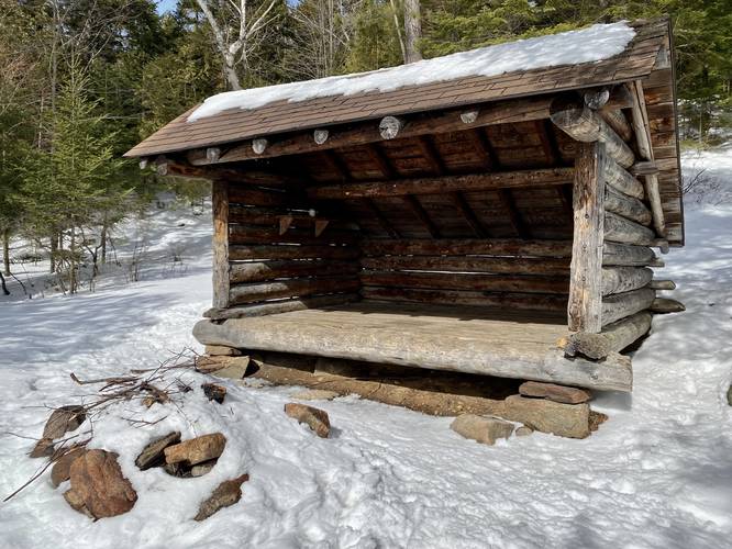
-
View of Copperas Pond, Stewart Mountain (snowy left), Sentinel Mountain (snowy middle), Kilburn Mountain (right)
44.331669, -73.899278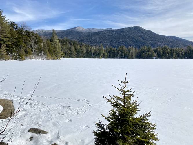
Hazards
Seasons
AllBlaze Color
2 Trip Reports


Helpful Links
Find Hiking Trails Near Me:


Before you leave...
MyHikes is an indie web platform aimed to make exploring public trails easier for everyone. The site has no investors and is owned and operated by one person, Dave Miller (Founder & Admin). As the Founder, main contributor, and doer-of-all-things for MyHikes, I share my trips with over-detailed write-ups for fun on a volunteer basis and I believe that public trail information should be available to everyone.
It takes a lot of time 🕦, money 💰, and effort (including espresso shots ☕) to run MyHikes, including hiking , mapping , writing , and publishing new trails with high-quality content... along with building new features, moderating, site maintainance, and app development for iOS and Android . I simply ask that if you find MyHikes' trail guides helpful to please consider becoming a Supporter to help keep the site, iOS, and Android apps available to everyone.
Supporters unlock website and in-app perks with a one-time payment of $25 (you renew) 😎👍. Or you can simply make a Donation of your choice without a MyHikes user account. Otherwise, telling your friends about MyHikes is the next-best thing - both quick and free 🎉
Thanks for visiting MyHikes and have a great hike!️

Dave Miller
MyHikes Founder & Admin

