Chimney Bluffs Loop Hike
Distance:
2.8 Miles / 4.5 kmType:
LoopDifficulty:
ModerateTime to Hike:
1 hour, ~24 minutesFeatures:
Surface Type:
Semi-PavedLoading...
Loading...
Chimney Bluffs Loop Hike at Chimney Bluffs State Park in Wolcott, New York is a moderate 2.8-mile loop hike that features beautiful views of the jagged rock bluffs along the shore of Lake Ontario.
Trails
This hike follows four named trails in the following clockwise order: Meadow Trail (fully paved / universally accessible), Bluff Trail (red blazes), Drumlin Trail (blue blazes), East-West Trail (yellow blazes). Note that the only paved and accessible trail here is the Meadow Trail (brown blazes).
Hike Description
This hike begins at the main (western) parking lot at Chimney Bluffs State Park and heads in along the Meadow Trail. The Meadow Trail is a universally accessible paved path that runs from the parking lot to the shore of Lake Ontario; however, it does not provide an accessible view of the Chimney Bluffs. Hikers will follow the Meadow Trail out to the fence line, where you can get a glimpse of the Chimney Bluffs in the distance (after the pavement ends). From here, hikers will hop off of the accessible trail and onto a dirt path named the Bluff Trail (red blazes).
Bluff Trail & Chimney Bluffs Views - Mile 0.25 to 1.5
At mile 0.25, hikers will hop on the Bluff Trail (red blazes) which leads east to reach views of the Chimney Bluffs. Along the way, hikers may find wildflowers in the Spring like Pink and White Trillium or yellow and purple Violets. The Bluff Trail lasts from mile 0.25 to 1.5.
Chimney Bluffs Views - Mile 0.5 to 1.5
At mile 0.5 is a small spur trail that leads to the shoreline with an obstructed view of Chimney Bluffs - worth skipping, but is useful to mark your own mileage. At mile 1.15, hikers will reach their first unobstructed close-up view of the Chimney Bluffs, located right on-trail - this is where the best views begin with another view right down the trail at mile 1.25. The best views of Chimney Bluffs sit between mile 1.35 and 1.5, with about 4 or 5 different places to get interesting views of the bluffs. One spot in particular allows hikers to view the bluffs from the exact ridge line of the largest bluff in the area, which provides a neat vista. You won't be disappointed as you hike along this trail with the jutting and jagged bluffs; however, once you reach mile 1.5, the views are done.
Drumlin Trail - Mile 1.5 to 2.1
From miles 1.5 to 2.1, hikers will follow the blue blazes of the Drumlin Trail. This trail really doesn't have much to see along the way; however, during the Spring time, hikers may find neat pitcher plants that grow alongside the trail. These pitcher plants are carnivorous plants that eat insects that fall into their pitcher.
East-West Trail - Mile 2.1 to 2.7
At mile 2.1, hikers will take a right-hand turn at the East-West Trail (yellow blazes) to head back to the Meadow Trail, which connects back to parking. Again, not much to see along this trail but it's a nice peaceful hike through the woods nonetheless.
Meadow Trail - Mile 2.7 to 2.8
At mile 2.7, hikers will take a left-hand turn at the Meadow Trail to reach the parking lot for a 2.8-mile loop hike.
Parking
Hikers will find a very large parking lot at the coordinates provided. The lot is large enough to fit a few dozen vehicles.
Fees
As of May 2023, there's a $5 parking fee per vehicle. A self-serve pay station can be found at the trailhead and accepts credit cards.
Pets
Dogs are allowed only if leashed and cleaned up after. The state park also has a limit of 2-dogs per party as of May 2023.
Restrooms
There are restrooms located at the trailhead.
Warning
Poison ivy: This loop hike had a lot of poison ivy located just off-trail and to the sides of the trails, watch your step.
-
Parking
43.281086, -76.922214 -
Main Trailhead
43.281234, -76.922186 -
Obstructed view of Chimney Bluffs
43.284111, -76.92215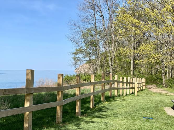
-
View of Lake Ontario
43.284169, -76.921897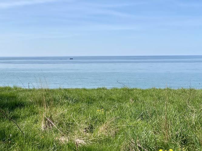
-
Small view of Chimney Bluffs
43.285156, -76.918756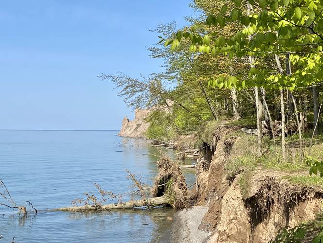
-
Chimney Bluffs
43.287228, -76.913003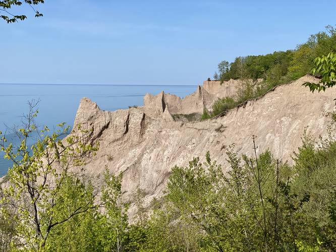
-
Chimney Bluffs
43.287239, -76.912056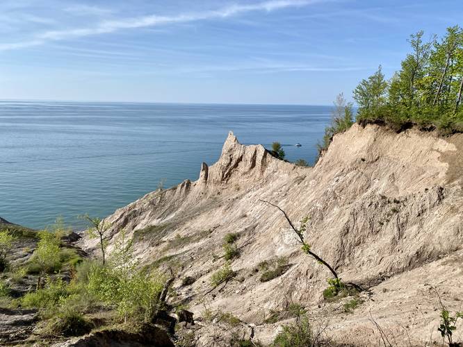
-
Chimney Bluffs
43.28815, -76.910392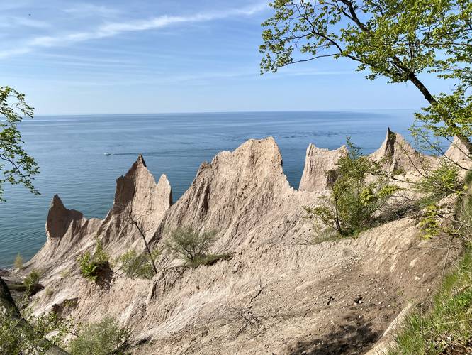
-
Chimney Bluffs ridge
43.288364, -76.9103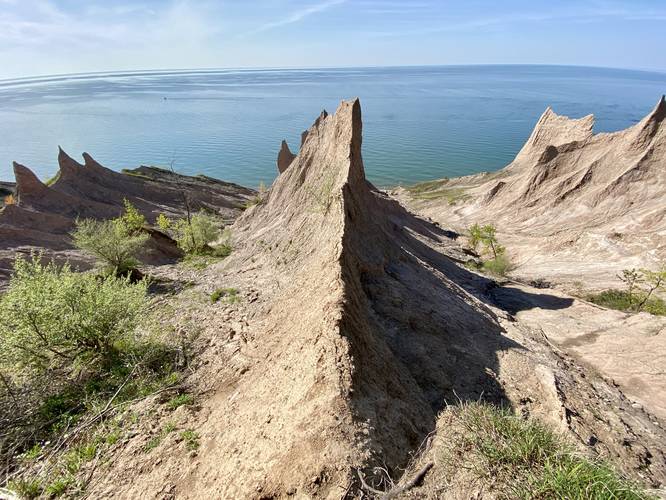
-
Chimney Bluffs
43.288331, -76.91005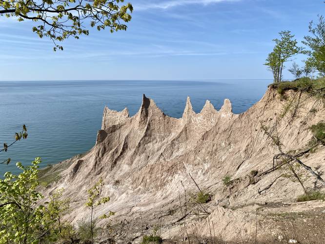
-
Chimney Bluffs
43.288611, -76.909164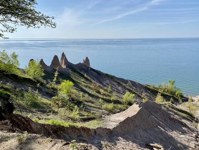
Hazards
Seasons
All
2 Trip Reports


Before you leave...
MyHikes is an indie web platform aimed to make exploring public trails easier for everyone. The site has no investors and is owned and operated by one person, Dave Miller (Founder & Admin). As the Founder, main contributor, and doer-of-all-things for MyHikes, I share my trips with over-detailed write-ups for fun on a volunteer basis and I believe that public trail information should be available to everyone.
It takes a lot of time 🕦, money 💰, and effort (including espresso shots ☕) to run MyHikes, including hiking , mapping , writing , and publishing new trails with high-quality content... along with building new features, moderating, site maintainance, and app development for iOS and Android . I simply ask that if you find MyHikes' trail guides helpful to please consider becoming a Supporter to help keep the site, iOS, and Android apps available to everyone.
Supporters unlock website and in-app perks with a one-time payment of $25 (you renew) 😎👍. Or you can simply make a Donation of your choice without a MyHikes user account. Otherwise, telling your friends about MyHikes is the next-best thing - both quick and free 🎉
Thanks for visiting MyHikes and have a great hike!️

Dave Miller
MyHikes Founder & Admin

