Cape Sebastian Trail (Coast Trail)
Distance:
2.7 Miles / 4.3 kmType:
Out-and-BackDifficulty:
EasyTime to Hike:
1 hour, ~21 minutesFeatures:
Surface Type:
DirtLoading...
Loading...
The Cape Sebastian Trail (Coast Trail) at the Cape Sebastian State Scenic Corridor in Gold Beach, Oregon is a moderate 2.7-mile out-and-back trail that runs along a steep ridge and down to Hunters Cove and features stunning views of the Oregon coastline.
This trail begins at the main parking lot and heads southwest and then eventually due-south heading downhill towards Hunters Cove. Along the hike down, hikers will pass benches at vista points that feature breathtaking views of the Oregon coast.
The trail winds down the hill, passing several switchbacks, before reaching Hunter Cove. Hunter Cove is yet another breathtaking beach where hikers can settle down for a picnic or just rest to take in the views before heading back uphill.
Views: The best view point along the trail can be found just 0.15-miles from the parking lot - just before the trail starts heading downhill. For people with not much time, at the very least, it's worth stopping by this lookout point.
Pets: Dogs are allowed if leashed and their waste must be carried out by the hiker.
Parking: Parking can be found at the coordinates provided in the large lot suitable for at least 20 vehicles.
-
Parking
42.328887, -124.425797 -
Main Trailhead
42.328934, -124.426173 -
Beautiful vista point - oregon coastline
42.328611, -124.428611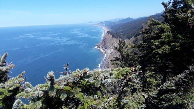
-
Vista point
42.319722, -124.428611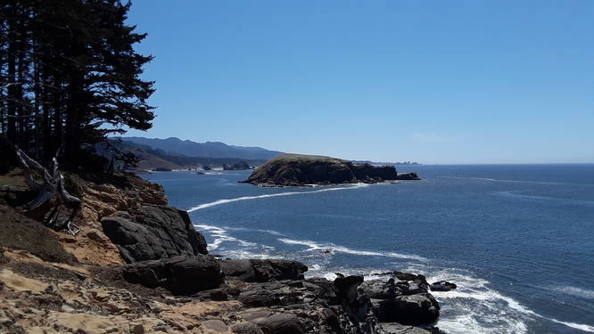
Hazards
Seasons
All
1 Trip Report


Helpful Links
Find Hiking Trails Near Me:


Before you leave...
MyHikes is an indie web platform aimed to make exploring public trails easier for everyone. The site has no investors and is owned and operated by one person, Dave Miller (Founder & Admin). As the Founder, main contributor, and doer-of-all-things for MyHikes, I share my trips with over-detailed write-ups for fun on a volunteer basis and I believe that public trail information should be available to everyone.
It takes a lot of time 🕦, money 💰, and effort (including espresso shots ☕) to run MyHikes, including hiking , mapping , writing , and publishing new trails with high-quality content... along with building new features, moderating, site maintainance, and app development for iOS and Android . I simply ask that if you find MyHikes' trail guides helpful to please consider becoming a Supporter to help keep the site, iOS, and Android apps available to everyone.
Supporters unlock website and in-app perks with a one-time payment of $25 (you renew) 😎👍. Or you can simply make a Donation of your choice without a MyHikes user account. Otherwise, telling your friends about MyHikes is the next-best thing - both quick and free 🎉
Thanks for visiting MyHikes and have a great hike!️

Dave Miller
MyHikes Founder & Admin

