Buttermilk Falls Trail
Distance:
0.3 Miles / 0.5 kmType:
Out-and-BackDifficulty:
EasyTime to Hike:
~9 minutesFeatures:
Surface Type:
DirtPark:
Buttermilk Falls ParkLoading...
Loading...
The Buttermilk Falls Trail at Buttermilk Falls Park in Beaver Falls, Pennsylvania is an easy 0.3 mile out-and-back hike to Buttermilk Falls which is also known as Homewood Falls. The waterfall is about 35 to 40 feet high that runs year-round, so this hike is great for any season.
The trail starts out from the parking lot by heading downhill into an old quarry before heading up stairs which leads over to the falls. To your left is the creek that Buttermilk Falls feeds into and there are small waterfalls right off of the trail at the trailhead. To your right is the old quarry - you can see where the the sandstone was mined out. This sandstone was primarily used in the construction of the Western Penitentiary in Pittsburgh, which is located just off of the western end of the Northshore Riverfront Trail.
The GPS data provided here brings you from parking, over to the falls, and then out on a separate trail that runs along the ridge of one of the quarry's cliffs. The cliff is only about 20 feet high, so it's good to watch your step here.
This is likely one of the best waterfall hikes outside of Pittsburgh, PA.
-
Parking
40.813022, -80.325497 -
Main Trailhead
40.813262, -80.325956 -
Buttermilk/Homewood Falls
40.814269, -80.327806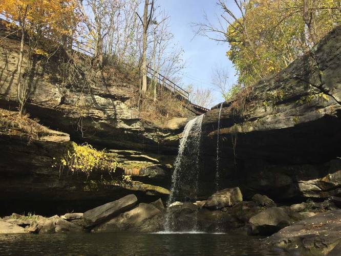
-
Smaller waterfall along the creek
40.813728, -80.327142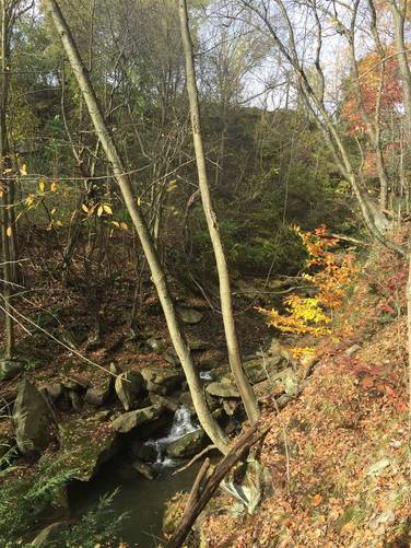
Hazards
Seasons
All
3 Trip Reports


Helpful Links
Find Hiking Trails Near Me:


Before you leave...
MyHikes is an indie web platform aimed to make exploring public trails easier for everyone. The site has no investors and is owned and operated by one person, Dave Miller (Founder & Admin). As the Founder, main contributor, and doer-of-all-things for MyHikes, I share my trips with over-detailed write-ups for fun on a volunteer basis and I believe that public trail information should be available to everyone.
It takes a lot of time 🕦, money 💰, and effort (including espresso shots ☕) to run MyHikes, including hiking , mapping , writing , and publishing new trails with high-quality content... along with building new features, moderating, site maintainance, and app development for iOS and Android . I simply ask that if you find MyHikes' trail guides helpful to please consider becoming a Supporter to help keep the site, iOS, and Android apps available to everyone.
Supporters unlock website and in-app perks with a one-time payment of $25 (you renew) 😎👍. Or you can simply make a Donation of your choice without a MyHikes user account. Otherwise, telling your friends about MyHikes is the next-best thing - both quick and free 🎉
Thanks for visiting MyHikes and have a great hike!️

Dave Miller
MyHikes Founder & Admin

