Bull Run Vista Loop
Distance:
4.0 Miles / 6.4 kmType:
LoopDifficulty:
ModerateTime to Hike:
2 hours, ~20 minutesFeatures:
Surface Type:
DirtLoading...
Loading...
The Bull Run Vista Loop at Tiadaghton State Forest in Waterville, Pennsylvania is a moderate and popular 4-mile hike that features views of the PA Grand Canyon and includes abandoned mountainside quarries.
Trails
This hike follows several named trails and roads in the following order: PA-44, Lower Pine Bottom Road, Tiadaghton Trail (yellow blazes), Eiger Trail / Waterville Quarry Trail / Quadfather (yellow blazes), Log Slide Trail (yellow blazes), and finally Lower Pine Bottom Road and PA-44 back to parking. This hike follows the loop in a clockwise order which is the easier route, by taking the Eiger / Waterville Quarry Trail first.
Hike Description
This hike begins at the Waterville Recreational Parking lot for the Pine Creek Trail and follows the main road over Pine Creek to reach Lower Pine Bottom Road. Note that, as of Jan 2023, there's signage that encourages hikers to instead park at the Tiadaghton State Forest district office located at the junction of Lower Pine Bottom Road and PA-44 so you don't have to hike along the highway. The mileage, from that parking lot, is similar to the hike listed here.
Trailhead to Eiger Trail - Mile 0.5 to 0.6
Once at the trailhead for the Tiadaghton Trail, located off of Lower Pine Bottom Road, hikers will follow the yellow blazes of this path for about 0.1-miles until they reach two trail junctions - first a junction with the Log Slide Trail and then a junction for the Eiger / Waterville Quarry Trail / Quadfather. This hike follows the Eiger / Waterville Quarry Trail / Quadfather first as the ascent is more moderate and enjoyable. Once on the Eiger Trail (Waterville Quarry Trail / Quadfather), hikers will face a moderate, some sometimes, steep uphill climb as you ascent the steep slopes of the northern side of the mountain.
Abandoned Quarry Sites - Miles 0.75 to 1.2
Once the hiker makes their way up the steeper portions of the Eiger / Waterville Quarry Trail (Quadfather), they'll reach flatter sections of trail that also have large rock outcroppings or cut-outs. These flat-cut rock outcroppings are old quarry sites that were once cash resources for companies and landowners in the late 1800s or early 1900s as the mountainsides were being harvested of their resources. Most of these quarry sites are cut into the mountainside with 20-foot rock walls surrounding open areas of forest floor. One section of the old quarry stands out more than others - located around mile 1.1 to 1.15 - are tall solid rock walls that span upwards of 40-feet up the mountainside, which were an unexpected sight. These solid rock walls may be a climbing opportunity for experienced climbers. Note that during cold months, this section of the mountain provides obstructed views of Pine Creek and the surrounding mountains, which was a nice addition to this trail. Hikers will finally pass a ton of rocky ledges and outcroppings between miles 1.2 and 1.4 before hitting the switchbacks of the "Quadfather Trail" that leads up the mountain.
Campsite - Mile 1.4
Just before the switchbacks is a very small campsite with a fire pit located at mile 1.4. This campsite is large enough for 1 tent on a small flat rock slab or room for hammock camping.
Switchbacks - Miles 1.4 to 1.9
From miles 1.4 to 1.9, hikers will follow the "Quadfather" section of the Eiger / Waterville Quarry Trail as it ascends the mountain via switchbacks. This part of the trail is actually the hardest to hike due to the small fist-sized rocks that litter a good portion of the trail here. Take your time up the switchbacks, don't count them, to be delightfully surprised the climb is over in just a half-mile. Once at mile 1.9, the trail levels out a bit as it heads toward the Bull Run Vista.
Bull Run Vista - Mile 2
Finally, at mile 2, hikers will reach the Bull Run Vista which provides stunning views of the PA Grand Canyon near Waterville. From the Bull Run Vista, hikers get a clear view of Huntley Mountain across the canyon along with views north up Pine Creek toward the town of Jersey Mills, PA. Note that there's a decent car-camping spot located right at this vista, which is another camping opportunity.
Log Slide Trail - Miles 2 to 3.4
After visiting the Bull Run Vista and taking in views of Pennsylvania's Grand Canyon, hikers will continue the loop by following the yellow blazes of the Log Slide Trail heading west from the vista. The Log Slide Trail is lined with mountain laurel which flower during June, a sight to see and reason to hike this in late Spring. Eventually the Log Slide Trail will head downhill at a steeper, moderate grade, as it passes through a grove of hemlock and pine trees. Around mile 2.75, along the mountain hollow, is a very-old stone road wall that was built under the trail to prevent erosion - still working over 100-years later. This old stone wall is over 100-feet long and about 3-4 feet tall and provides structure for the old log slide, now-turned hiking trail. Last point-of-interest along the Log Slide Trail is the last abandoned quarry site located at mile 3.3.
Junction to Road
Once off of the Log Slide Trail, take a left-hand turn to head back to Lower Pine Bottom Rd along the Tiadaghton Trail. Finally hike back to parking along PA-44 or back up to the state forest district office (safer parking area) to complete the hike.
Parking
Note that hikers should ideally park at the Tiadaghton State Forest district office located 10 Lower Pine Bottom Road Waterville, PA (41.31344, -77.38262). DCNR encourages hikers to park there and walk down the entrance road by taking a short-cut trail along the way. We didn't know this until after parking at the Waterville Recreational Parking area across Pine Creek, hence the GPS track and parking location. You can choose to hike this whichever way you want, but note that traffic along PA-44 can be heavier and more dangerous during warmer months. Hike at your own risk.
Pets
Dogs are allowed if leashed and their waste should be carried out by the hiker.
Warning
Timber Rattlesnakes: The Timber Rattlesnake is known to live in this area and loves rocky outcroppings. As such, hikers should be on the lookout for rattlesnakes between the months of May - October, especially around rock outcroppings or open sunny areas where they like to sunbathe.
Steep terrain: This hike follows some skinny trails along very steep mountainous terrain. Hikers who are afraid of heights may have a difficult time, especially on the Eiger / Waterville Quarry Trail section of the hike. The Log Slide Trail is by far the steepest trail in the loop.
Highway walk: If parking at the coordinates provided east of Pine Creek, hike at your own risk along PA-44 or instead, park at the district office (see Parking notes).
Camping
There's one campsite along the trail; however, it's only large enough for about 1 tent. Backpackers can also camp at the Bull Run Vista as there's large open space that provides car-camping opportunities as well. Please follow all state forest rules and regulations when backcountry / primitive / dispersed camping.
-
Parking
41.311481, -77.376637 -
Main Trailhead
41.311439, -77.376756 -
Turn onto Tiadaghton Trail
41.312722, -77.384544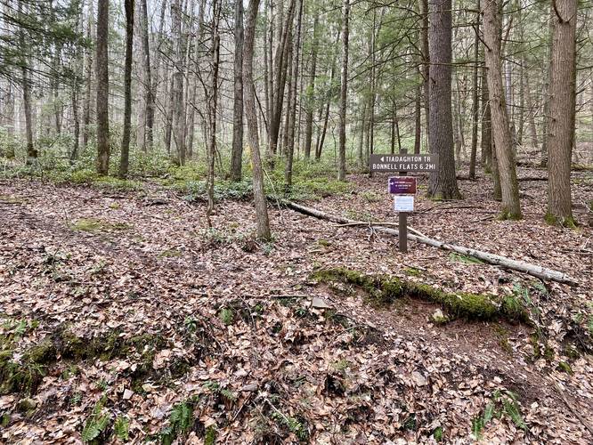
-
Right-Hand turn to Eiger Trail (Waterville Quarry Trail)
41.312144, -77.382667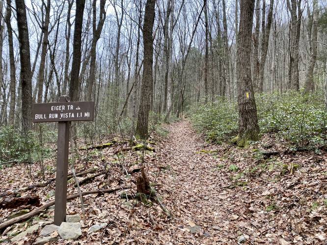
-
Quarry site
41.310756, -77.381906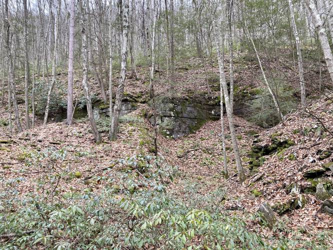
-
Quarry site
41.3079, -77.379936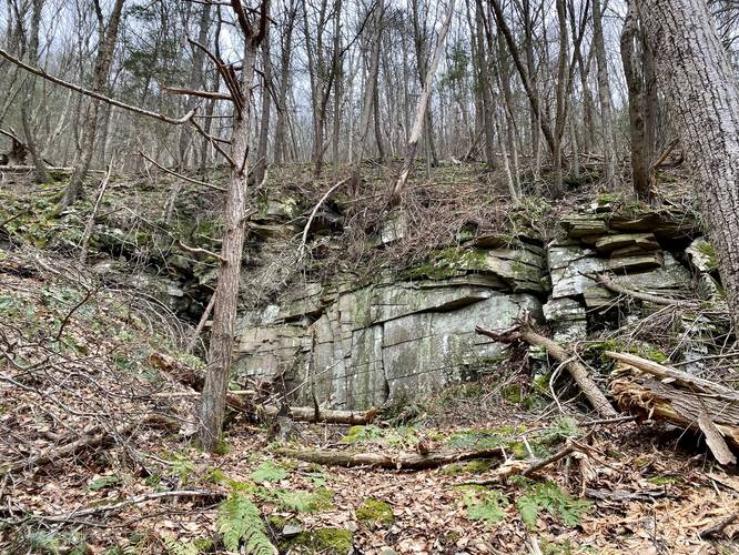
-
Large rock walls (30-40 feet tall) old quarry site
41.307872, -77.379386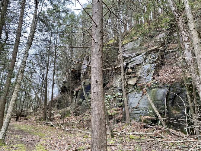
-
Dave & Jax at the tall rock walls (abandoned quarry site)
41.307808, -77.378494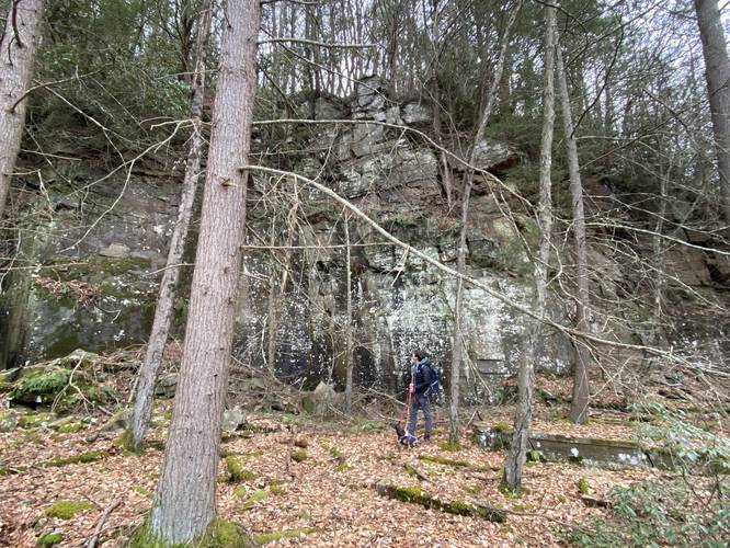
-
Old quarry site
41.307481, -77.378128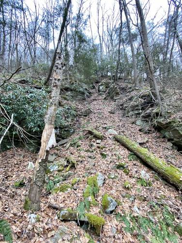
-
Large (100-foot long) rock wall built for log sliding, circa late 1800s early 1900s
41.305333, -77.387703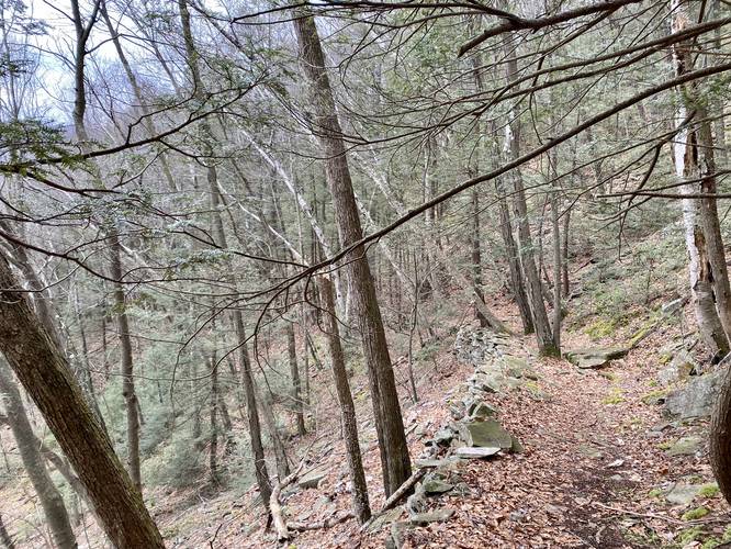
-
Old quarry site
41.311372, -77.384164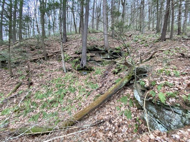
-
View of Pine Creek from PA-44 bridge
41.311836, -77.379394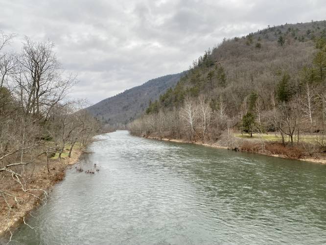
-
Campsite (small)
41.306686, -77.375014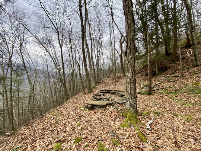
-
Bull Run Vista
41.305233, -77.379128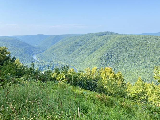
-
View Trail Map
Hiker: CoreyBHiked on: August 19, 2023Distance: 3.9 miles / 6.3 km
Hazards
Seasons
All

3 Trip Reports


Helpful Links
Find Hiking Trails Near Me:


")


Before you leave...
MyHikes is an indie web platform aimed to make exploring public trails easier for everyone. The site has no investors and is owned and operated by one person, Dave Miller (Founder & Admin). As the Founder, main contributor, and doer-of-all-things for MyHikes, I share my trips with over-detailed write-ups for fun on a volunteer basis and I believe that public trail information should be available to everyone.
It takes a lot of time 🕦, money 💰, and effort (including espresso shots ☕) to run MyHikes, including hiking , mapping , writing , and publishing new trails with high-quality content... along with building new features, moderating, site maintainance, and app development for iOS and Android . I simply ask that if you find MyHikes' trail guides helpful to please consider becoming a Supporter to help keep the site, iOS, and Android apps available to everyone.
Supporters unlock website and in-app perks with a one-time payment of $25 (you renew) 😎👍. Or you can simply make a Donation of your choice without a MyHikes user account. Otherwise, telling your friends about MyHikes is the next-best thing - both quick and free 🎉
Thanks for visiting MyHikes and have a great hike!️

Dave Miller
MyHikes Founder & Admin

