Bridal Veil Falls Trail
Distance:
0.6 Miles / 1.0 kmType:
Out-and-BackDifficulty:
ModerateTime to Hike:
~18 minutesFeatures:
Surface Type:
DirtLoading...
Loading...
The Bridal Veil Falls Trail in Corbett, Oregon is a moderate 0.6 mile out-and-back hike to the base of Bridal Veil Falls in the heart of the Columbia River Gorge. Bridal Veil Falls has two main cascades and according to the state park's website, the two cascades in total are about 120 feet tall.
The trail that leads down to the falls is not wheelchair accessible and has a couple of switchbacks before reaching Bridal Veil Creek. Cross the bridge at the creek and follow the trail back uphill for about 60 feet to a lookout point directly in front of the falls.
The entire hike is about 0.6 miles out-and-back and is moderate based on the short distance and elevation gain heading back to parking, which is about 70 feet. This is one of the best waterfalls outside of Portland, Oregon within a short 30 minute drive of the city.
For additional views of the Columbia River, check out the short Bridal Veil Overlook Loop Trail before heading out.
-
Parking
45.553023, -122.183564 -
Main Trailhead
45.553454, -122.182765 -
Bridal Veil Falls, Oregon
45.555019, -122.180014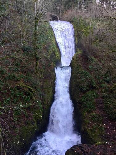
-
Bridal Veil Falls, Oregon
45.555017, -122.180016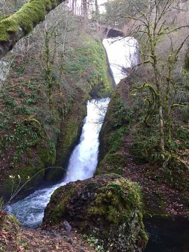
Seasons
All

2 Trip Reports


Helpful Links
Find Hiking Trails Near Me:


Before you leave...
MyHikes is an indie web platform aimed to make exploring public trails easier for everyone. The site has no investors and is owned and operated by one person, Dave Miller (Founder & Admin). As the Founder, main contributor, and doer-of-all-things for MyHikes, I share my trips with over-detailed write-ups for fun on a volunteer basis and I believe that public trail information should be available to everyone.
It takes a lot of time 🕦, money 💰, and effort (including espresso shots ☕) to run MyHikes, including hiking , mapping , writing , and publishing new trails with high-quality content... along with building new features, moderating, site maintainance, and app development for iOS and Android . I simply ask that if you find MyHikes' trail guides helpful to please consider becoming a Supporter to help keep the site, iOS, and Android apps available to everyone.
Supporters unlock website and in-app perks with a one-time payment of $25 (you renew) 😎👍. Or you can simply make a Donation of your choice without a MyHikes user account. Otherwise, telling your friends about MyHikes is the next-best thing - both quick and free 🎉
Thanks for visiting MyHikes and have a great hike!️

Dave Miller
MyHikes Founder & Admin

