Battle Creek Falls Trail
Distance:
1.2 Miles / 1.9 kmType:
Out-and-BackDifficulty:
ModerateTime to Hike:
~36 minutesFeatures:
Surface Type:
DirtLoading...
Loading...
Battle Creek Falls Trail within Uinta National Forest near Pleasant Grove, Utah is a moderate 1.2-mile out-and-back hike that leads to the 60-foot tall waterfall, Battle Creek Falls.
Hike Description
This hike begins at the main parking lot for Kiwanis Park and follows the Battle Creek Trail as it leads up the southwestern slopes of Mt. Timpanogos. The trail itself is wide with a substrate of dirt and includes patches of loose gravel. Hikers will make their way up the Battle Creek valley with views of the Mt. Timpanogos foothills ahead of you. Along the way, hikers will find a small human-made waterfall / spillway located around mile 0.38, which is a neat spot to take a little break.
Battle Creek Footbridge - Mile 0.47
At mile 0.47, hikers will reach a small wooden footbridge that spans Battle Creek. During my early Autumn September hike, the water level was just below this footbridge. I can only assume that during periods of heavy rainfall or snow melt, this footbridge might be impassible, but that's speculation.
Battle Creek Falls - Mile 0.55
At mile 0.55, hikers will reach a steep but short trail that leads downhill to the base of the ~60-foot tall Battle Creek Falls. Once at the base of Battle Creek Falls, hikers can enjoy cooling down in the mist of the waterfall as it sifts down the canyon.
After visiting Battle Creek Falls, this short route leads hikers back down the same trail to reach parking. Along the way are a couple of nice views of the greater Provo area.
Parking
Hikers will find a large parking lot at the coordinates provided, large enough to fit over a couple dozen vehicles.
Pets
Dogs are allowed on this trail if leashed and must be cleaned up after.
-
Parking
40.36271, -111.700533 -
Main Trailhead
40.363025, -111.700802 -
View from the trail
40.367583, -111.693314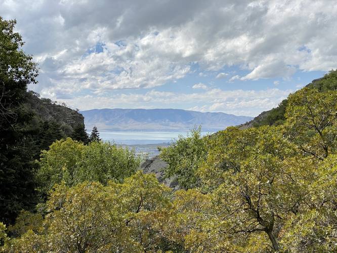
-
Small human-made waterfall
40.366567, -111.696228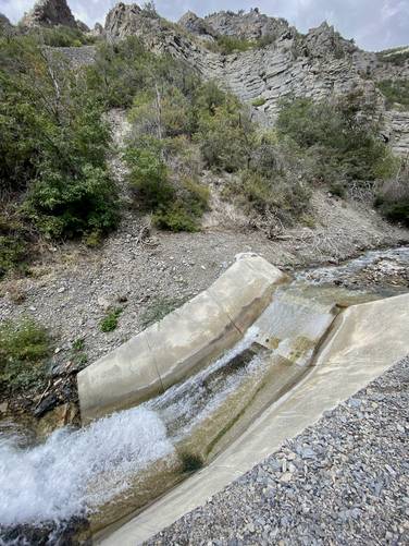
-
Battle Creek Falls, approx. 60-feet tall
40.367456, -111.693047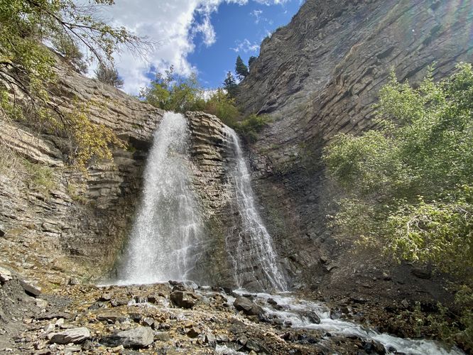
Hazards
Seasons
All
1 Trip Report


Helpful Links
Find Hiking Trails Near Me:


Before you leave...
MyHikes is an indie web platform aimed to make exploring public trails easier for everyone. The site has no investors and is owned and operated by one person, Dave Miller (Founder & Admin). As the Founder, main contributor, and doer-of-all-things for MyHikes, I share my trips with over-detailed write-ups for fun on a volunteer basis and I believe that public trail information should be available to everyone.
It takes a lot of time 🕦, money 💰, and effort (including espresso shots ☕) to run MyHikes, including hiking , mapping , writing , and publishing new trails with high-quality content... along with building new features, moderating, site maintainance, and app development for iOS and Android . I simply ask that if you find MyHikes' trail guides helpful to please consider becoming a Supporter to help keep the site, iOS, and Android apps available to everyone.
Supporters unlock website and in-app perks with a one-time payment of $25 (you renew) 😎👍. Or you can simply make a Donation of your choice without a MyHikes user account. Otherwise, telling your friends about MyHikes is the next-best thing - both quick and free 🎉
Thanks for visiting MyHikes and have a great hike!️

Dave Miller
MyHikes Founder & Admin

