Ape Cave
Distance:
2.5 Miles / 4.0 kmType:
Out-and-BackDifficulty:
EasyTime to Hike:
1 hour, ~15 minutesSurface Type:
DirtLoading...
Exploring Ape Cave at Gifford Pinchot National Forest near Cougar, Washington is a easy 2.5-mile hike that leads hikers down into the dark underground lava tube of Ape Cave.
The cave does not have much to see, but it is a unique experience nonetheless. Hiking through a lava tube, especially at this size, is certainly worth seeing once. Including the return hike, this trip is under 3 miles, hence the 2.5-mile total.
After entering the cave, there are signs for "Upper Cave" and "Lower Cave". The Lower Cave is an easy kid-friendly walk that ends after about 3/4-mile. The Upper Cave is just over 1-mile long but there's an exit at the other end so hikers can get back to parking above ground.
The Upper Cave section is still an easy walk but it requires a little bit of climbing, so it may not be suitable for children. Near the end of the Upper Cave is a solidified lava flow, about 8 feet tall, that has some foothold carved into it for climbing.
Permit and Fee
Hikers are required to get a permit to enter Ape Cave. The permit can be purchased at the parking lot.
Parking
Hikers will find a decent sized lot at the parking coordinates provided, but this lot can get busy during the Summer.
Warning
Hikers will need at least two light sources per person to illuminate enough distance for it to be safe. Consider purchasing headlamps before this trip, otherwise during the Summer, lanterns can be rented at the kiosk near the entrance. Hike at your own risk.
For more info, check out the Ape Cave Norcalhiker blog post.
-
Parking
46.108374, -122.211428
Season
Summer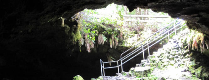
1 Trip Report


Helpful Links
Find Hiking Trails Near Me:


Before you leave...
MyHikes is an indie web platform aimed to make exploring public trails easier for everyone. The site has no investors and is owned and operated by one person, Dave Miller (Founder & Admin). As the Founder, main contributor, and doer-of-all-things for MyHikes, I share my trips with over-detailed write-ups for fun on a volunteer basis and I believe that public trail information should be available to everyone.
It takes a lot of time 🕦, money 💰, and effort (including espresso shots ☕) to run MyHikes, including hiking , mapping , writing , and publishing new trails with high-quality content... along with building new features, moderating, site maintainance, and app development for iOS and Android . I simply ask that if you find MyHikes' trail guides helpful to please consider becoming a Supporter to help keep the site, iOS, and Android apps available to everyone.
Supporters unlock website and in-app perks with a one-time payment of $25 (you renew) 😎👍. Or you can simply make a Donation of your choice without a MyHikes user account. Otherwise, telling your friends about MyHikes is the next-best thing - both quick and free 🎉
Thanks for visiting MyHikes and have a great hike!️

Dave Miller
MyHikes Founder & Admin

