Agnew Road Trail
Distance:
2.0 Miles / 3.2 kmType:
One-WayDifficulty:
EasyTime to Hike:
1 hourFeatures:
Surface Type:
DirtLoading...
Loading...
The Agnew Road Trail at Hays Woods, Pittsburgh, PA, is a 2 mile one-way hike that starts at end of Agnew Road (off Becks Run Road), leads into the center of Hay's Woods, before heading downhill and ends at the intersection of Glass Run Rd and Route 885.
Hay's Woods can be tricky to navigate, so follow these tips for turns along the trail (if heading west to east):
Miles 0 - 0.3: Stay straight on the trail at the first left-hand turn. Upon 0.3 miles in, you'll find a fork, stay left here.
Miles 0.3 - 0.45: Stay left after the first fork, for the next 2 trail intersections.
Miles 0.45 - 0.9: Continue straight and at the next trail intersection, take your right-hand turn.
Mile 0.9: Head straight through this trail junction.
Mile 1.1: Lookout point of the Monongahela River, Cathedral of Learning, and Oakland.
Mile 1.3: Small loop that connects back to main trail - stay right, but does not matter.
Mile 1.4: You have 3 options - stay straight, go left (depicted in trail map), or take a right-hand turn and head south. Each of these trails meets back up to one another on the eastern side. To follow the trail map here, take a left. This is the last trail junction before heading down and out of Hay's Woods at the eastern trail terminus.
Dogs and biking are allowed on this trail.
-
Parking
40.398275, -79.963356 -
Main Trailhead
40.398194, -79.963131 -
Vista of Greenfield and Oakland in Pittsburgh
40.394567, -79.944775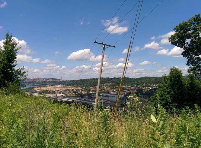
Hazards
Seasons
All
2 Trip Reports


Helpful Links
Find Hiking Trails Near Me:


Before you leave...
MyHikes is an indie web platform aimed to make exploring public trails easier for everyone. The site has no investors and is owned and operated by one person, Dave Miller (Founder & Admin). As the Founder, main contributor, and doer-of-all-things for MyHikes, I share my trips with over-detailed write-ups for fun on a volunteer basis and I believe that public trail information should be available to everyone.
It takes a lot of time 🕦, money 💰, and effort (including espresso shots ☕) to run MyHikes, including hiking , mapping , writing , and publishing new trails with high-quality content... along with building new features, moderating, site maintainance, and app development for iOS and Android . I simply ask that if you find MyHikes' trail guides helpful to please consider becoming a Supporter to help keep the site, iOS, and Android apps available to everyone.
Supporters unlock website and in-app perks with a one-time payment of $25 (you renew) 😎👍. Or you can simply make a Donation of your choice without a MyHikes user account. Otherwise, telling your friends about MyHikes is the next-best thing - both quick and free 🎉
Thanks for visiting MyHikes and have a great hike!️

Dave Miller
MyHikes Founder & Admin

