Yovimpa Point Trail
Distance:
0.3 Miles / 0.5 kmType:
Out-and-BackDifficulty:
EasyTime to Hike:
~9 minutesFeatures:
Surface Type:
DirtLoading...
Loading...
The Yovimpa Point Trail at Bryce Canyon National Park near Bryce Canyon City, Utah is an easy 0.3 out-and-back hike that features southern views of Bryce Canyon National Park.
This short woodland trail leads hikers from the main parking lot for Rainbow Point, located on the southeastern corner, and heads through the woods to reach Yovimpa Point. Along the way, the trail dips down into the forest and then back out to the viewpoint with minimal elevation change. From Yovimpa Point, hikers will get views far into the distance, like Navajo Mountain located ~100-miles away or the Pink Cliffs within the Grand Staircase-Escalante National Monument.
Fees
Bryce Canyon National Park has a $35/week entry fee as of September 2023. Visitors are highly encouraged to purchase an annual National Parks pass
before their trip to reduce entry fees (especially if you're passing
through multiple parks) and to also speed-up the very-long line that
leads into the park.
Parking
Visitors will find a large parking lot at the coordinates provided.
Pets
Dogs are not allowed on this trail.
-
Parking
37.474693, -112.240318 -
Main Trailhead
37.474394, -112.240314 -
Southward view from Yovimpa Point at Bryce Canyon National Park
37.472458, -112.240342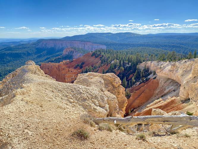
-
Views from Yovimpa Point at Bryce Canyon National Park
37.472392, -112.240264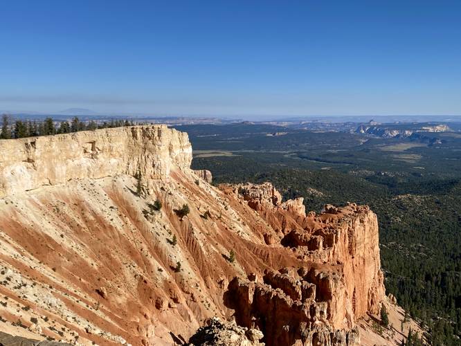
Hazards
Seasons
All
2 Trip Reports


Helpful Links
Find Hiking Trails Near Me:


Before you leave...
MyHikes is an indie web platform aimed to make exploring public trails easier for everyone. The site has no investors and is owned and operated by one person, Dave Miller (Founder & Admin). As the Founder, main contributor, and doer-of-all-things for MyHikes, I share my trips with over-detailed write-ups for fun on a volunteer basis and I believe that public trail information should be available to everyone.
It takes a lot of time 🕦, money 💰, and effort (including espresso shots ☕) to run MyHikes, including hiking , mapping , writing , and publishing new trails with high-quality content... along with building new features, moderating, site maintainance, and app development for iOS and Android . I simply ask that if you find MyHikes' trail guides helpful to please consider becoming a Supporter to help keep the site, iOS, and Android apps available to everyone.
Supporters unlock website and in-app perks with a one-time payment of $25 (you renew) 😎👍. Or you can simply make a Donation of your choice without a MyHikes user account. Otherwise, telling your friends about MyHikes is the next-best thing - both quick and free 🎉
Thanks for visiting MyHikes and have a great hike!️

Dave Miller
MyHikes Founder & Admin

