Waipo'o Falls Lookout
Distance:
0 Miles / 0 kmType:
Out-and-BackDifficulty:
EasyTime to Hike:
~5 minutesFeatures:
Surface Type:
DirtLoading...
Loading...
The Waipo'o Falls Lookout at Waimea Canyon State Park in Waimea, Hawaii (Kauai) is an easy loop or out-and-back walk that leads to a roadside vista of Waipo'o Falls cascading several thousand feet into Waimea Canyon.
This is not really a hike or a walk, but rather a nice quick roadside stop along a self-guided tour of Kauai. Hikers can actually reach the top of the 800-foot cascade of Waipo'o Falls by hiking the Canyon Trail to Waipo'o Falls at Waimea Canyon State Park for a moderate to difficult 3.3-mile out-and-back trek. Note that the view from this lookout is far better than the on-trail view, since it's impossible to see the 800-foot cascade from the top of the waterfall.
Parking
Visitors will find a parking turnout by the vista. The turnout is large enough for a few vehicles. Across the street is a picnic area with more parking.
Respecting the Land
Hawaiian land is considered sacred to native Hawaiians and many locals, so please stay on-trail, take nothing but photos, and leave nothing but footprints. Respect the locals - don't stay for long and have a backup hike planned in case the parking lot is full.
-
Parking
22.101666, -159.677295 -
Main Trailhead
22.101697, -159.677312 -
View of Waipo'o Falls
22.101575, -159.6772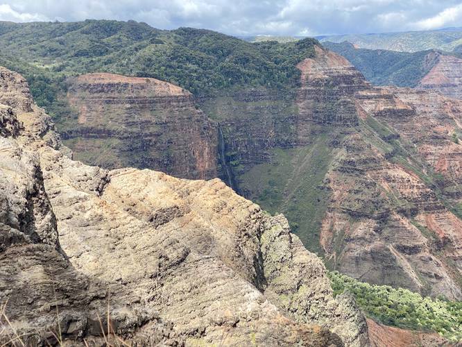
Hazards
Seasons
All
2 Trip Reports


Helpful Links
Find Hiking Trails Near Me:


Before you leave...
MyHikes is an indie web platform aimed to make exploring public trails easier for everyone. The site has no investors and is owned and operated by one person, Dave Miller (Founder & Admin). As the Founder, main contributor, and doer-of-all-things for MyHikes, I share my trips with over-detailed write-ups for fun on a volunteer basis and I believe that public trail information should be available to everyone.
It takes a lot of time 🕦, money 💰, and effort (including espresso shots ☕) to run MyHikes, including hiking , mapping , writing , and publishing new trails with high-quality content... along with building new features, moderating, site maintainance, and app development for iOS and Android . I simply ask that if you find MyHikes' trail guides helpful to please consider becoming a Supporter to help keep the site, iOS, and Android apps available to everyone.
Supporters unlock website and in-app perks with a one-time payment of $25 (you renew) 😎👍. Or you can simply make a Donation of your choice without a MyHikes user account. Otherwise, telling your friends about MyHikes is the next-best thing - both quick and free 🎉
Thanks for visiting MyHikes and have a great hike!️

Dave Miller
MyHikes Founder & Admin

