Valley View Trail
Distance:
0.5 Miles / 0.8 kmType:
One-WayDifficulty:
EasyTime to Hike:
~15 minutesFeatures:
Surface Type:
DirtLoading...
Loading...
The Valley View Trail in Davis, West Virginia is an easy 0.5 mile one-way trail that leads along the western edge of the Dolly Sods Wilderness with views of Canaan Valley and the surrounding mountain ranges.
Once on the ridge, this trail is an easy walk with amazing views throughout the entirety of the hike. To the north, there's a lookout point called Windy View, which sits atop a rock that juts out from the ridge. Benches can be found along this trail as well so you can sit down and take in the views.
Backpacking Dolly Sods: If you're passing through Dolly Sods along the Rocky Ridge Trail, you should plan to hike the Valley View Trail at least one-way since the view is much better than the view you get from the Rocky Ridge Trail.
Parking: Note that there is no public parking near the trail itself as this is a gated community who have to turn visitors away. Please do not drive to the actual trailhead! The closest public parking area can be found at the coordinates provided at a very small parking lot next to the Dolly Sods FR-80 Trail -- located on a long and narrow dirt road at the top of the mountain next to the Dolly Sods Wilderness. This parking lot is approximately 2.5-miles away, one-way by foot, from the actual trail. So hikers must hike in on the Dolly Sods FR-80 Trail before reaching the Rocky Ridge Trail to reach this trail, making this a 5-miles out-and-back hike just to reach this trail. Alternatively, hikers can park along FR-75 on the east side of Dolly Sods Wilderness near the Bear Rocks Trail for a much longer hike to reach this trail. The parking lot is much larger and more accessible than the western side of Dolly Sods Wilderness, which makes it a preferable place to find parking.
Trailheads: Please note that there are technically 3 trailheads for the Valley View Trail - the trailhead listed here can be found at the southern terminus for this trail along the Rocky Ridge Trail. The main trailhead can be found up the short spur trail from the gated community (not accessible to the general public), and the third trailhead can be found at the northern section of this GPS data, along the Rocky Ridge Trail. If you're hiking along the Rocky Ridge Trail, you can spot the northern terminus easily by finding the multitude of large stone cairns.
-
Parking
39.024177, -79.398748 -
Main Trailhead
39.042474, -79.382862 -
Windy View lookout
39.047844, -79.381286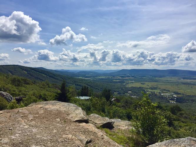
-
Northern terminus to the Rocky Ridge Trail
39.047531, -79.379731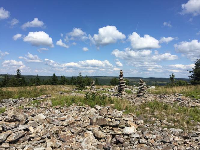
Hazards
Seasons
All
3 Trip Reports


Helpful Links
Find Hiking Trails Near Me:


Before you leave...
MyHikes is an indie web platform aimed to make exploring public trails easier for everyone. The site has no investors and is owned and operated by one person, Dave Miller (Founder & Admin). As the Founder, main contributor, and doer-of-all-things for MyHikes, I share my trips with over-detailed write-ups for fun on a volunteer basis and I believe that public trail information should be available to everyone.
It takes a lot of time 🕦, money 💰, and effort (including espresso shots ☕) to run MyHikes, including hiking , mapping , writing , and publishing new trails with high-quality content... along with building new features, moderating, site maintainance, and app development for iOS and Android . I simply ask that if you find MyHikes' trail guides helpful to please consider becoming a Supporter to help keep the site, iOS, and Android apps available to everyone.
Supporters unlock website and in-app perks with a one-time payment of $25 (you renew) 😎👍. Or you can simply make a Donation of your choice without a MyHikes user account. Otherwise, telling your friends about MyHikes is the next-best thing - both quick and free 🎉
Thanks for visiting MyHikes and have a great hike!️

Dave Miller
MyHikes Founder & Admin

