Upper Rock Run Falls
Distance:
0.2 Miles / 0.3 kmType:
Out-and-BackDifficulty:
ModerateTime to Hike:
~6 minutesFeatures:
Surface Type:
DirtLoading...
Loading...
Upper Rock Run Falls at the McIntyre Wild Area near McIntyre Township,
Pennsylvania is a moderate 0.2-mile out-and-back trail that leads to the
beautiful 10-foot tall rockslide waterfall, Upper Rock Run Falls.
The trail begins by following a fairly steep hillside down to a fishing game commission A-frame cabin. From here, the trail becomes flat as it makes its way out to Upper Rock Run Falls, which is only about 200-feet from the cabin.
At the waterfall, hikers will find several rock ledges above Rock Run, so hiking further downstream may have opportunities for climbing or bouldering above the creek. The waterfall itself is a beautiful cascade, approximately 10-feet tall, that spills into a pool of green-ish blue water below.
Pets
Dogs area allowed if leashed and their waste must be carried out.
Parking
Hikers will find a large parking lot at the coordinates provided - large enough to fit about twelve vehicles.
Swimming
This
is the most popular swimming hole along Rock Run. Expect a crowd on weekends and show up early. For another beautiful rockslide waterfall, check out Middle Rock Run Falls. For a more quiet swimming experience, check out Lower Rock Run Falls.
-
Parking
41.521767, -76.907845 -
Main Trailhead
41.521733, -76.907713 -
Upper Rock Run Falls
41.522186, -76.906525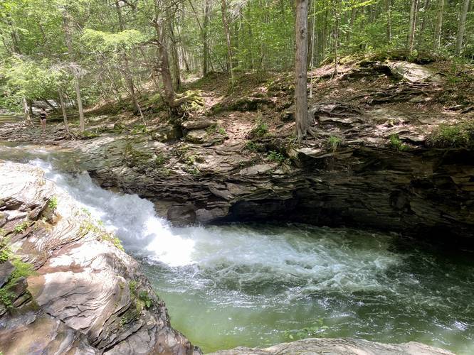
Hazards
Seasons
All
2 Trip Reports


Helpful Links
Find Hiking Trails Near Me:


")


Before you leave...
MyHikes is an indie web platform aimed to make exploring public trails easier for everyone. The site has no investors and is owned and operated by one person, Dave Miller (Founder & Admin). As the Founder, main contributor, and doer-of-all-things for MyHikes, I share my trips with over-detailed write-ups for fun on a volunteer basis and I believe that public trail information should be available to everyone.
It takes a lot of time 🕦, money 💰, and effort (including espresso shots ☕) to run MyHikes, including hiking , mapping , writing , and publishing new trails with high-quality content... along with building new features, moderating, site maintainance, and app development for iOS and Android . I simply ask that if you find MyHikes' trail guides helpful to please consider becoming a Supporter to help keep the site, iOS, and Android apps available to everyone.
Supporters unlock website and in-app perks with a one-time payment of $25 (you renew) 😎👍. Or you can simply make a Donation of your choice without a MyHikes user account. Otherwise, telling your friends about MyHikes is the next-best thing - both quick and free 🎉
Thanks for visiting MyHikes and have a great hike!️

Dave Miller
MyHikes Founder & Admin

