Timber Point Trail
Distance:
0.7 Miles / 1.1 kmType:
Out-and-BackDifficulty:
EasyTime to Hike:
~21 minutesFeatures:
Surface Type:
DirtLoading...
Loading...
This section of the Timber Point Trail at the Rachel Carson Wildlife Refuge in Biddeford, Maine is an easy 0.7-mile out-and-back trail that includes beautiful views of Curtis Cove and leads to a nice viewing platform along a tidal river named Little River before turning back. The main highlight of this hike - not included in this GPS track - is Timber Point located further down the trail. In addition to Timber Point, the map depicts that hikers can reach Timber Island during low tide only, but must be warned that if not timed properly, you can get stuck on Timber Island until the next low tide approaches.
Hike Description
Please note that this trail is significantly longer than the track provided here, which was recorded in mid-July 2021. We ended up turning back due to an abundance of mosquitos.
The trail begins at the end of Granite Point Rd in Biddeford, Maine where a small paved parking lot can be found, in addition to a larger dirt parking lot located river-side.
The trail itself follows what appears to be a private road that passes Curtis Cove - featuring scenic views of the cove before keeping to the right at a junction near the southern end of the cove.
The trail then heads south headed for Timber Point and Timber Island. This recording stops along the first viewing platform along Little River before heading back to parking. The mosquitos were pretty terrible for this very short hike, but since the trail sits next to a saltwater marsh, it was clear that the mosquitos likely would not let-up, so we turned back.
Parking
Hikers will find parking at the coordinates provided. The paved lot is large enough to fit about 5 cars, while the dirt lot is large enough to fit about 10 cars.
Pets
Dogs are not allowed on this trail as of July 2021.
Biking
Biking is not allowed on this trail as of July 2021.
Hazards
Seasons
All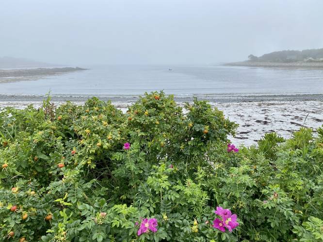
2 Trip Reports


Helpful Links
Find Hiking Trails Near Me:


")


Before you leave...
MyHikes is an indie web platform aimed to make exploring public trails easier for everyone. The site has no investors and is owned and operated by one person, Dave Miller (Founder & Admin). As the Founder, main contributor, and doer-of-all-things for MyHikes, I share my trips with over-detailed write-ups for fun on a volunteer basis and I believe that public trail information should be available to everyone.
It takes a lot of time 🕦, money 💰, and effort (including espresso shots ☕) to run MyHikes, including hiking , mapping , writing , and publishing new trails with high-quality content... along with building new features, moderating, site maintainance, and app development for iOS and Android . I simply ask that if you find MyHikes' trail guides helpful to please consider becoming a Supporter to help keep the site, iOS, and Android apps available to everyone.
Supporters unlock website and in-app perks with a one-time payment of $25 (you renew) 😎👍. Or you can simply make a Donation of your choice without a MyHikes user account. Otherwise, telling your friends about MyHikes is the next-best thing - both quick and free 🎉
Thanks for visiting MyHikes and have a great hike!️

Dave Miller
MyHikes Founder & Admin

