The Castle
Distance:
0.1 Miles / 0.2 kmType:
Out-and-BackDifficulty:
EasyTime to Hike:
~5 minutesFeatures:
Surface Type:
DirtLoading...
Loading...
The Castle at Capitol Reef National Park near Fruita, Utah is a 0.1-mile out-and-back walk that leads to a viewpoint of the natural rock formation known as The Castle.
This is not a hike but rather a short walk along a roadside stop that leads to the western-most viewpoint of The Castle. Note that there's another, smaller, parking turnout located on the East side of The Castle, which is arguably nicer depending on the time of day / natural lighting, but does provide a different view and perspective of this interesting rock formation. The Castle towers over UT-24 and is not easy to miss as you're driving the route through Capitol Reef National Park. This stop includes additional signage, with an arrow, to ensure you know which rock formation to look at.
Parking
Visitors will find a large parking turnout at the coordinates provided, located on the south side of UT-24.
Pets
Dogs are allowed here and at other public parking lots
within the park. Dogs must be leashed and cleaned up after. Please read
more about Capitol Reef National Park's pet rules.
-
Parking
38.298524, -111.272471 -
Main Trailhead
38.298415, -111.272432 -
The Castle at Capitol Reef National Park
38.298142, -111.272233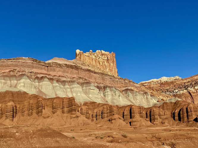
Hazards
Seasons
All
2 Trip Reports


Helpful Links
Find Hiking Trails Near Me:


Before you leave...
MyHikes is an indie web platform aimed to make exploring public trails easier for everyone. The site has no investors and is owned and operated by one person, Dave Miller (Founder & Admin). As the Founder, main contributor, and doer-of-all-things for MyHikes, I share my trips with over-detailed write-ups for fun on a volunteer basis and I believe that public trail information should be available to everyone.
It takes a lot of time 🕦, money 💰, and effort (including espresso shots ☕) to run MyHikes, including hiking , mapping , writing , and publishing new trails with high-quality content... along with building new features, moderating, site maintainance, and app development for iOS and Android . I simply ask that if you find MyHikes' trail guides helpful to please consider becoming a Supporter to help keep the site, iOS, and Android apps available to everyone.
Supporters unlock website and in-app perks with a one-time payment of $25 (you renew) 😎👍. Or you can simply make a Donation of your choice without a MyHikes user account. Otherwise, telling your friends about MyHikes is the next-best thing - both quick and free 🎉
Thanks for visiting MyHikes and have a great hike!️

Dave Miller
MyHikes Founder & Admin

