Tank Hollow Vista
Distance:
1.1 Miles / 1.8 kmType:
Out-and-BackDifficulty:
EasyTime to Hike:
~33 minutesFeatures:
Surface Type:
DirtLoading...
Loading...
Tank Hollow Vista at State Game Lands 141 near Jim Thorpe, Pennsylvania is an easy 1.1-mile out-and-back hike that leads to a stunning view of the Lehigh Gorge known as Tank Hollow Vista.
Trails
This hike follows one named trail: Tank Hollow Trail.
Hike Description
This hike begins at the main trailhead for the Tank Hollow Trail located at (40.945683, -75.691963) along the SGL 141 entrance road. We hiked this during open hunting season, so it was easy to drive to the trailhead -- just do not trust Google Maps to get you there, please read the Parking & How to get to Tank Hollow Vista section below for more details.
The trail starts off with an obvious "Tank Hollow Trail" sign a couple-dozen feet into the trail, so you know you're on the right path. Hike down this trail for a half-mile to reach the vista. Along the way, hikers will pass through an open forest before the trail becomes swallowed-up by tall rhododendron that enclose you as you approach the vista.
Tank Hollow Vista - Mile 0.52
Around mile 0.52, hikers will pass through the rhododendron cover to reach the rocky outcropping on the side of the Lehigh Gorge with a stunning view of the gorge -- this is Tank Hollow Vista. Hikers will find different vantage points to take-in the sights of the Lehigh Gorge from this rock outcropping. From Tank Hollow Vista, hikers get a view of the Lehigh River as it cuts
through the Lehigh Gorge in an ultra-secluded part of Pennsylvania, but
not far from large populations -- hence, why this spot is so popular. Watch your step as you traverse some of the rocks as there are steep and deep drop-offs in between some of the cracks.
The hike out obviously follows the same path to complete this 1-mile out-and-back hike (assuming the entrance road gate is open).
Parking & How to get to Tank Hollow Vista
Getting to the Tank Hollow Trail trailhead can be a bit tricky. As of November 2023, Google Maps has no idea how to direct people to the trailhead without routing them the wrong way. The easiest way to find the Tank Hollow Trail and this trailhead is to drive to the parking coordinates provided (40.941407, -75.672378) which will lead hikers to the SGL 141 entrance road. There's a massive parking lot located there. During hunting season (October thru January), the gate should be open and thus the road is drive-able. If the gate is closed, then you must walk along Buzzard's Point Road to reach the trailhead. With the gate closed, the Buzzard's Point Road walk will increase the mileage from ~1-mile out-and-back to a ~3.5 or 4-mile out-and-back hike. If the gate is open, you can easily drive to the trailhead which is located at (40.945683, -75.691963).
Parking lot size @ trailhead: Medium turnout, large enough to fit ~6 vehicles. Scarce parking along the entrance road, pull all the way off the road to not block traffic.
Parking lot size @ entrance road: Very large. Lot is large enough to fit several dozen vehicles.
Mileage to hike Tank Hollow Vista
If the State Game Lands gate at (40.941407, -75.672378) is closed, then the mileage for this hike is about 3.5 to 4-miles out-and-back. During hunting season (October thru January), the gate should be open and you can drive the entrance road -- in that case, the mileage is ~1-mile out-and-back.
Total Time to hike Tank Hollow Vista
SGL 141 Gate Open: ~35 minutes
SGL 141 Gate Closed: ~1.5 to 2-hours.
Warning
Hunting: SGL 141 is mostly accessible to the public during hunting season, so you must wear blaze orange when hiking through this area as it's a state law. When not in hunting season, you do not need to wear blaze orange. Please check the PA Game Commission's website to find out more about when hunting is open.
Steep ledges: This hike leads to a rock outcropping with steep drop-offs and ledges. Watch your step and hike at your own risk.
-
Parking
40.941407, -75.672378 -
Main Trailhead
40.945683, -75.691964 -
Tank Hollow Vista, view of the Lehigh Gorge
40.948631, -75.699761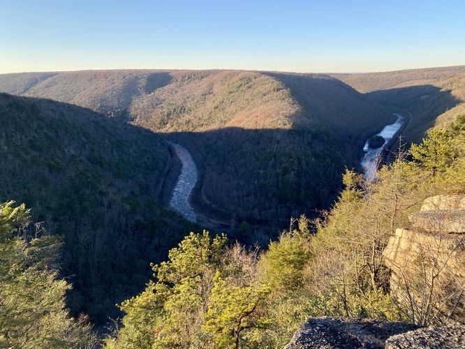
Hazards
Seasons
All
3 Trip Reports


Helpful Links
Find Hiking Trails Near Me:


Before you leave...
MyHikes is an indie web platform aimed to make exploring public trails easier for everyone. The site has no investors and is owned and operated by one person, Dave Miller (Founder & Admin). As the Founder, main contributor, and doer-of-all-things for MyHikes, I share my trips with over-detailed write-ups for fun on a volunteer basis and I believe that public trail information should be available to everyone.
It takes a lot of time 🕦, money 💰, and effort (including espresso shots ☕) to run MyHikes, including hiking , mapping , writing , and publishing new trails with high-quality content... along with building new features, moderating, site maintainance, and app development for iOS and Android . I simply ask that if you find MyHikes' trail guides helpful to please consider becoming a Supporter to help keep the site, iOS, and Android apps available to everyone.
Supporters unlock website and in-app perks with a one-time payment of $25 (you renew) 😎👍. Or you can simply make a Donation of your choice without a MyHikes user account. Otherwise, telling your friends about MyHikes is the next-best thing - both quick and free 🎉
Thanks for visiting MyHikes and have a great hike!️

Dave Miller
MyHikes Founder & Admin

