Silver Star Mountain
Distance:
7.6 Miles / 12.2 kmType:
Out-and-BackDifficulty:
HardTime to Hike:
3 hours, ~48 minutesFeatures:
Surface Type:
DirtLoading...
Loading...
The Silver Star Mountain hike at Gifford Pinchot National Forest near Creswell Heights, Washington is a moderate-to-difficult 7.6-mile out-and-back trek that leads to the summit of Silver Star Mountain and features stunning views.
Trails
This hike follows two named trails: Grouse Vista Trail #108F, Silver Star Trail #180.
Hike Description
This trek begins where the two forest roads - L-1200 Rd and W-1200 Rd meet at the coordinates provided. Hikers will start their climb by heading north along the Grouse Vista Trail.
Pyramid Rock
Around mile 1.65, hikers will pass a mountain summit called Pyramid Rock, located to the right-hand side of the trail.
Silver Star Trail - Mile 2.65
Around mile 2.65, hikers will reach the Silver Star Trail. Take a left-hand turn here to continue hiking toward the summit of Silver Star Mountain. This trail will pass several more junctions before reaching the summit, so follow the signs or your trail map.
Silver Star Mountain Summit - Mile 3.8
At approximately 3.7-miles into the trek, hikers will reach the saddle of Silver Star Mountain - with the summit located just 0.1-miles to the north. Hikers will reach the summit around mile 3.8 (give or take). While the summit has excellent views, hikers will also find views to the south as well. Check out the southern-facing views before hiking back down the mountain.
Hiking Back
While the way back is identical, but opposite to the hike in, it's worth nothing that trekking poles are worth bringing on this hike to take some stress off of your knees. Take breaks on the way down and enjoy the scenery as you go.
Parking
Hikers will find parking near the coordinates provided.
Pets
Dogs are allowed if leashed and their waste must be carried out by the hiker.
Camping and Backpacking
While there are no designated campsites along this trail, backpacking is permitted at Gifford Pinchot National Forest. Please follow all rules and regulations when dispersed / primitive / backcountry camping.
Seasons
All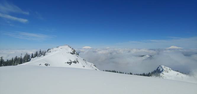
1 Trip Report


Helpful Links
Find Hiking Trails Near Me:


Before you leave...
MyHikes is an indie web platform aimed to make exploring public trails easier for everyone. The site has no investors and is owned and operated by one person, Dave Miller (Founder & Admin). As the Founder, main contributor, and doer-of-all-things for MyHikes, I share my trips with over-detailed write-ups for fun on a volunteer basis and I believe that public trail information should be available to everyone.
It takes a lot of time 🕦, money 💰, and effort (including espresso shots ☕) to run MyHikes, including hiking , mapping , writing , and publishing new trails with high-quality content... along with building new features, moderating, site maintainance, and app development for iOS and Android . I simply ask that if you find MyHikes' trail guides helpful to please consider becoming a Supporter to help keep the site, iOS, and Android apps available to everyone.
Supporters unlock website and in-app perks with a one-time payment of $25 (you renew) 😎👍. Or you can simply make a Donation of your choice without a MyHikes user account. Otherwise, telling your friends about MyHikes is the next-best thing - both quick and free 🎉
Thanks for visiting MyHikes and have a great hike!️

Dave Miller
MyHikes Founder & Admin

