Rollaway Falls
Distance:
0.2 Miles / 0.3 kmType:
Out-and-BackDifficulty:
ModerateTime to Hike:
~6 minutesFeatures:
Surface Type:
DirtLoading...
Loading...
Rollaway Falls at Tioga State Forest near Leetonia, Pennsylvania is a moderate 0.2-mile out-and-back hike, including a creek crossing, that features a two-tiered waterfall named Rollaway Falls.
Hike Description
Note that this waterfall sits on the opposite side of Cedar Run creek, so hikers who wish to visit this waterfall up close will have to wade through the knee-deep creek first. During colder months, especially during the winter, this can be very dangerous. It's recommended to bring trekking poles to ensure better footing while crossing the creek.
Lower Rollaway Falls - 25-feet Tall
After hikers wade across Cedar Run, they'll find Lower Rollaway Falls which cascades down bedrock before reaching the creek below. Lower Rollaway Falls has a very small free-fall cascade before the water tumbles down the rock. In its entirety, the waterfall is about 25-feet tall and 50-feet long.
Upper Rollaway Falls - 15-feet tall
Hikers can make their way above Lower Rollaway Falls to reach Upper Rollaway Falls with a little bit of effort. The terrain next to Lower Rollaway Falls is super steep, so trekking poles come in handy here as well. Stay on the right-side of Lower Rollaway Falls to reach the top for the easiest route. Once above Lower Rollaway Falls, it's a short walk to reach the base of Upper Rollaway Falls. The upper falls section has a 15-foot cascade where the water falls off sheer bedrock before tumbling down some smaller falls before the water reaches Lower Rollaway Falls. While standing at the base of Upper Rollaway Falls, hikers will note the large bedrock cutout above and around them - likely formed from glaciers.
Parking
Hikers will find parking off of Leetonia Road near the coordinates provided. There's enough room for a couple of vehicles by the large bend in the road.
Pets
Dogs should be left at your car unless Cedar Run creek is extremely low.
Warnings
Creek crossing: To reach the base of both tiers of this waterfall, hikers must cross a knee-deep creek.
Falling rock: Surrounding this waterfall are some large rock ledges which appear to have been carved out by glaciers. Be careful since sometimes these rock ledges will let some of its rocks loose, sending them plummeting into the gorge below.
Steep terrain: To reach Upper Rollaway Falls, hikers need to scramble up steep terrain, watch your step.
-
Parking
41.571798, -77.466722 -
Main Trailhead
41.572006, -77.466962 -
Lower Rollaway Falls, approx. 25-feet tall
41.572258, -77.466933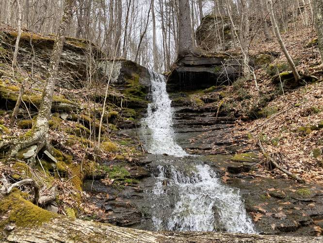
-
Hike up and around Lower Rollaway Falls
41.572236, -77.466798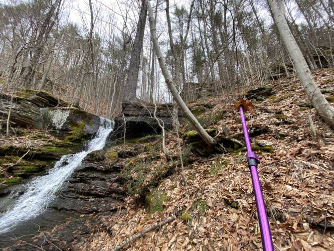
-
Upper Rollaway Falls, approx. 15-feet tall
41.572564, -77.466797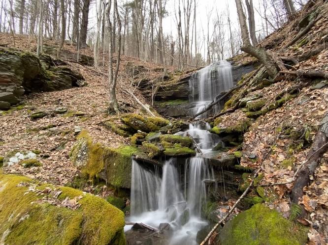
Hazards
Seasons
All
1 Trip Report


Helpful Links
Find Hiking Trails Near Me:


Before you leave...
MyHikes is an indie web platform aimed to make exploring public trails easier for everyone. The site has no investors and is owned and operated by one person, Dave Miller (Founder & Admin). As the Founder, main contributor, and doer-of-all-things for MyHikes, I share my trips with over-detailed write-ups for fun on a volunteer basis and I believe that public trail information should be available to everyone.
It takes a lot of time 🕦, money 💰, and effort (including espresso shots ☕) to run MyHikes, including hiking , mapping , writing , and publishing new trails with high-quality content... along with building new features, moderating, site maintainance, and app development for iOS and Android . I simply ask that if you find MyHikes' trail guides helpful to please consider becoming a Supporter to help keep the site, iOS, and Android apps available to everyone.
Supporters unlock website and in-app perks with a one-time payment of $25 (you renew) 😎👍. Or you can simply make a Donation of your choice without a MyHikes user account. Otherwise, telling your friends about MyHikes is the next-best thing - both quick and free 🎉
Thanks for visiting MyHikes and have a great hike!️

Dave Miller
MyHikes Founder & Admin

