Rocky Pond Road Loop
Distance:
4.7 Miles / 7.6 kmType:
LoopDifficulty:
ModerateTime to Hike:
2 hours, ~21 minutesFeatures:
Surface Type:
DirtLoading...
Loading...
The Rocky Pond Road Loop at Leominster State Forest in Princeton, Massachusetts is a moderate 4.7-mile loop hike that follows six trails in the park and passes Paradise Pond with views along the way.
Trail Name (s): Rocky Pond Road, Paradise Alley, King Tuts Highway, Old County Road, Wolf Rock Road, Unnamed Trails.
Trailhead Location: Rocky Pond Trailhead, Route 31 Princeton MA.
Allowed activities: hiking, birding, geocaching, nature study, hunting, biking, snowmobiling limited to un-paved roads, cross country skiing, snowshoeing, fishing,, horseback riding, non-motorized boating.
WARNING: Hunting is allowed except on Sundays. Wear colors that will keep you safe (i.e.: Blaze Orange). The Sportsman’s club, with live range firing, abuts the State forest to the east. Do not access this area from any of the forest trails.
Forbidden activities: No littering, No alcohol, No fires, No off road vehicles, No camping, No swimming except at Crow Hills Pond
Hours: Trails are open daily from sunrise to sunset.
Parking and fees: There is a fee to park from Memorial Day to Labor Day in the paved parking lots. For Massachusetts residents the fee is $8.00 per vehicle, for non-residents the fee is $15.00. The fee is determined by the state on the license plate. There is plenty of parking at the Rocky Pond Trailhead lot. This lot is not paved and there is no Ranger to collect fees. Fees are collected on a Donation and honor system with a metal Self pay station near the trailhead Kiosk.
Pets: Dogs must remain on a leash at all times and pet waste must be carried out with the hiker.
Accessibility: The trails at this location are not wheelchair accessible. If visitors have a sturdy stroller with wide wheels meant for rough terrain, and if visitors kept to the trails named as “ROADS”, then such a stroller would do fine.
Sanitation: There are no restrooms at the Rocky Pond Trailhead parking area or along any of the trails. One trash bin is at the trailhead sign; visitors are strongly encouraged to “carry out” any trash.
Trail information: There is an information Kiosk at the trailhead with a posted map, with maps to take or borrow. A map is NOT an option here, unless you are very familiar with this forest. BRING A MAP. To download and print a trail map before your visit, please click the link below:
https://www.mass.gov/files/documents/2018/10/25/leominster-2018.pdf
All the major “roads” and junction points have named wooden signs placed high up so they could be seen even in winter months. Orange plastic “tape” was tied to several trees marking the route along an unnamed trail between “King Tut’s Highway” and “Wolf Rock Road”. We did not see any traditional trail blaze markers on our hike.
WARNING: There are very few traditional trail blaze markers in this forest. Make sure to bring a map and GPS device and use them. A GPS device is extremely useful here, as it is extremely easy to get lost in this huge forest. Stay on the trails and use your map.
Length and features: This was an easy 4.7 mile trek done as a “loop” hike. Our hike began from the Rocky Pond trailhead traveling northeast down Rocky Pond Road which is wide, flat and well shaded with trees. The substrate here is packed gravel. We took a right off of Rocky Pond Road onto Paradise Alley heading south. The trail continues through a mixed forest along a small stream bed. There are several fun, well maintained geocaches to be found in this park and Paradise Alley takes hikers past one that’s easy to find. Continuing on and keeping to the right, we traveled onto some un-named trails. Hikers will be able to get a good look at Paradise Pond without straying too far off and losing sight of the trail. We kept to the right, continued southward onto King Tut’s Highway. King Tut’s Highway is another wide flat road. At the junction of King Tut’s Highway and Old County Road, we headed to the right westward to find another geocache. After our find, we retraced our steps down Old County road, past the junction point for a short bit before turning back to King Tut’s Highway and onto the first un-named trail that we encountered off to the right. We found that keeping to the right, heading eastward at un-named trail junctions and referring to the map often, kept us going in the direction we plotted to create a loop. We began to see that someone had started marking the trail with orange plastic tape tied to trees in strategic locations. Otherwise there were only the well-traveled footfalls to keep us on the trail. Continuing in an eastward direction the trail intersected Wolf Rock Road with its posted sign. At this junction we turned left, heading north back toward King Tut’s Highway. At the Junction of King Tut’s Highway and Rocky Pond Road we turned left, headed west retracing our steps past Paradise Alley and back to the parking lot.
About the Park: Leominster State Forest is a publicly owned forest that covers some 4,246 acres of land. The forest includes the towns of: Leominster, Fitchburg, Princeton, Sterling, and Westminster. There is a vast array of trails to hike here, and although this Forest is well known and very popular, hikers will not feel crowded on the trails. Visitors will often feel as though they have the forest all to themselves. There is a wide variety of terrain along the trails, ranging from wide flat fire roads, to narrow single file pathways. None of the trails on this hike were difficult, and only on occasion was the footing rocky or gravely. The loose substrate was mostly on the descents so care should be taken on those slicker parts of the trail. Nature lovers will be astounded at the abundance of mountain laurel seen here. A visit during the bloom in late June and early July must be breath taking.
Although the trails (for the most part) are “blaze free”, they are very well maintained. Thanks in part to the efforts of the New England Mountain Bike Association (NEMBA) for helping to keep the trails in excellent shape. The Wachusett Chapter of NEMBA has four trail maintenance days, two each in spring and fall. Everyone is welcome to volunteer to maintain the trails at the park. For more information please follow the link: https://nemba.org/
Explore 74 trails near Princeton, MAHazards
Seasons
All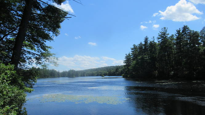
1 Trip Report


Helpful Links
Find Hiking Trails Near Me:


")
Before you leave...
MyHikes is an indie web platform aimed to make exploring public trails easier for everyone. The site has no investors and is owned and operated by one person, Dave Miller (Founder & Admin). As the Founder, main contributor, and doer-of-all-things for MyHikes, I share my trips with over-detailed write-ups for fun on a volunteer basis and I believe that public trail information should be available to everyone.
It takes a lot of time 🕦, money 💰, and effort (including espresso shots ☕) to run MyHikes, including hiking , mapping , writing , and publishing new trails with high-quality content... along with building new features, moderating, site maintainance, and app development for iOS and Android . I simply ask that if you find MyHikes' trail guides helpful to please consider becoming a Supporter to help keep the site, iOS, and Android apps available to everyone.
Supporters unlock website and in-app perks with a one-time payment of $25 (you renew) 😎👍. Or you can simply make a Donation of your choice without a MyHikes user account. Otherwise, telling your friends about MyHikes is the next-best thing - both quick and free 🎉
Thanks for visiting MyHikes and have a great hike!️

Dave Miller
MyHikes Founder & Admin

