Red Loop
Distance:
1.2 Miles / 1.9 kmType:
LoopDifficulty:
ModerateTime to Hike:
~36 minutesFeatures:
Surface Type:
DirtLoading...
Loading...
The Red Loop at the East Glenwood Open Space Preserve in Scotts Valley, California is a moderate 1-mile loop trail that features wide open views of the hills of the area and includes an abundance of wildlife during the Spring like rabbits, bullfrogs, and other open space critters.
Hike Description
This trail begins after hikers make their way down the 0.4-mile Entrance Trail. In this GPS recording, the track heads in a clockwise direction, first passing views of Scotts Valley before hitting the banks of a small pond. When entering cow fence areas, be sure to close the gate behind you - like at the pond.
After passing the pond, the trail will head up into the hills, meandering around with some views and wildflowers, like wild lupine, along the way. Eventually the trail makes its way back to the start, but not before passing through a shaded forest, which is a nice break from the mostly sun-exposed trail.
Pets
Note that dogs are not allowed due to the East Glenwood Open Space
Preserve's use of cow grazing to keep rare wildlife (both plants and
animals) flourishing here. For nearby dog-friendly trails, check out the West Glenwood Preserve instead.
Warnings
Rattlesnakes, mountain lion, wasps, poison oak, ticks, and sun exposure.
Prohibited
No camping, no plant/animal/mineral collecting, no motorized vehicles or horses. No smoking, no alcohol.
-
Parking
37.06853, -122.004985 -
Main Trailhead
37.070253, -121.999975 -
Pond view
37.071903, -122.001372
-
View / Overlook / Vista
37.072456, -121.998511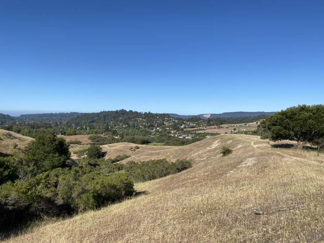
Hazards
Seasons
AllBlaze Color
1 Trip Report


Helpful Links
Find Hiking Trails Near Me:


Before you leave...
MyHikes is an indie web platform aimed to make exploring public trails easier for everyone. The site has no investors and is owned and operated by one person, Dave Miller (Founder & Admin). As the Founder, main contributor, and doer-of-all-things for MyHikes, I share my trips with over-detailed write-ups for fun on a volunteer basis and I believe that public trail information should be available to everyone.
It takes a lot of time 🕦, money 💰, and effort (including espresso shots ☕) to run MyHikes, including hiking , mapping , writing , and publishing new trails with high-quality content... along with building new features, moderating, site maintainance, and app development for iOS and Android . I simply ask that if you find MyHikes' trail guides helpful to please consider becoming a Supporter to help keep the site, iOS, and Android apps available to everyone.
Supporters unlock website and in-app perks with a one-time payment of $25 (you renew) 😎👍. Or you can simply make a Donation of your choice without a MyHikes user account. Otherwise, telling your friends about MyHikes is the next-best thing - both quick and free 🎉
Thanks for visiting MyHikes and have a great hike!️

Dave Miller
MyHikes Founder & Admin

