Rattler Run Falls
Distance:
0.1 Miles / 0.2 kmType:
Out-and-BackDifficulty:
EasyTime to Hike:
~5 minutesFeatures:
Surface Type:
DirtLoading...
Loading...
Rattler Run Falls at Tioga State Forest in Morris, Pennsylvania is an easy 0.1-mile out-and-back walk that leads to the 15-foot multi-tiered waterfall known as Rattler Run Falls.
Walk Description
This is not a hike, but rather somewhat sketchy off-road walk that leads into a creek hollow where a 15-foot multi-tiered waterfall can be found - Rattler Run Falls. Hikers will find one very small parking turnout across the street from the waterfall, located on the north side of the Tioga State Forest sign, on public land. Hikers, carefully, will cross the street and walk up the north side of the creek's banks. Maybe 20-feet from the road is where the walk stops, along a rocky leaf-filled forest to get a nice view of the waterfall.
Rattler Run Falls, Approx. 15-feet Tall
The waterfall, Rattler Run Falls, is about 15-feet tall in total split into two cascades. The upper cascade is about 10-feet tall with a lower cascade of about 5-feet or so. Below the main waterfall is another rock ledge where the water spills over at about 3-feet tall.
Private Property Line
Please note that the southern banks of
Rattler Run creek is on private property, while the northern side of the
creek is on state forest lands. Please be respectful of the locals and
property owners - do not walk on private property, do not park on
private property, and if you choose to go here, please do not stay long.
Waterfall's Ghostly-White Color
The white water cascading
down Haunted Mine Falls is treated with a special material to lower the
acidity levels in the water, as all of this water is essentially acid
mine run-off. The massive human-made pools at the top of the mountain
treat the water before it sends it down into Wilson Creek, causing the
water to appear a ghostly-white. I believe the substance used to treat
the water is calcitic limestone.
Parking
There's a very small parking turnout, large enough for 1 car, at the coordinates provided located near the
coordinates provided on the east side of the road; however, please be
careful when crossing the highway as cars travel about 55+
MPH here. Only park on public land - north of the state forest sign - and far enough off of the highway.
Pets
Dogs are allowed if leashed and cleaned up after.
Warning
Highway traffic:
Hikers must cross or walk along PA-287 to reach Rattler Run which
can be sketchy. Parking here can be kind of sketchy as well because
there's just one very small parking turnout on public land that can fit just one vehicle. Watch the traffic and hike
at your own risk as traffic generally drives 55+ MPH down this highway.
-
Parking
41.607363, -77.295163 -
Main Trailhead
41.607461, -77.295282 -
Rattler Run Falls, approx. 15-feet tall (long exposure)
41.607336, -77.295632
Hazards
Seasons
All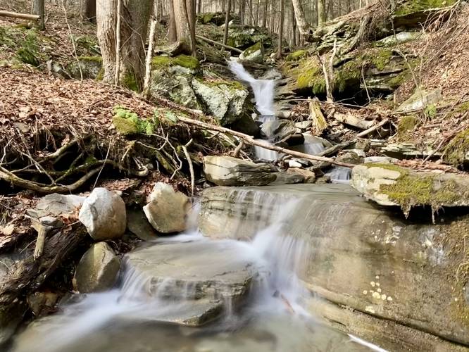
1 Trip Report


")

Before you leave...
MyHikes is an indie web platform aimed to make exploring public trails easier for everyone. The site has no investors and is owned and operated by one person, Dave Miller (Founder & Admin). As the Founder, main contributor, and doer-of-all-things for MyHikes, I share my trips with over-detailed write-ups for fun on a volunteer basis and I believe that public trail information should be available to everyone.
It takes a lot of time 🕦, money 💰, and effort (including espresso shots ☕) to run MyHikes, including hiking , mapping , writing , and publishing new trails with high-quality content... along with building new features, moderating, site maintainance, and app development for iOS and Android . I simply ask that if you find MyHikes' trail guides helpful to please consider becoming a Supporter to help keep the site, iOS, and Android apps available to everyone.
Supporters unlock website and in-app perks with a one-time payment of $25 (you renew) 😎👍. Or you can simply make a Donation of your choice without a MyHikes user account. Otherwise, telling your friends about MyHikes is the next-best thing - both quick and free 🎉
Thanks for visiting MyHikes and have a great hike!️

Dave Miller
MyHikes Founder & Admin

