Race Brook Falls - Lower Falls
Distance:
1.3 Miles / 2.1 kmType:
Out-and-BackDifficulty:
ModerateTime to Hike:
~39 minutesFeatures:
Surface Type:
DirtLoading...
Loading...
The Race Brook Falls - Lower Falls hike at Mount Everett State Reservation near Sheffield, Massachusetts is a moderate 1.3-mile out-and-back trek that leads to a ~80-foot tall waterfall, Lower Race Brook Falls.
Trails: This hike follows two named trails: Race Brook Falls Trail, Lower Falls Trails.
Hike Description: Hikers will begin following the Race Brook Falls Trail at the parking lot before taking a right-hand turn at the Lower Falls Trail around mile 0.25. From here, hikers will follow the Lower Falls Trail right to the base of the 80-foot tall Lower Race Brook Falls.
Parking: Hikers will find parking directly off Route 41 in a small pull-off at the coordinates provided.
Blaze Colors: This hike follows blue blazes.
-
Parking
42.089446, -73.411209 -
Main Trailhead
42.089346, -73.411436 -
80-foot tall Race Brook Falls - Lower Falls
42.089558, -73.421561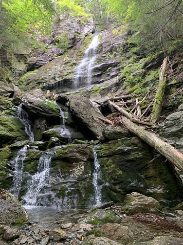
Hazards
Seasons
AllBlaze Color

1 Trip Report


Helpful Links
Find Hiking Trails Near Me:


")
Before you leave...
MyHikes is an indie web platform aimed to make exploring public trails easier for everyone. The site has no investors and is owned and operated by one person, Dave Miller (Founder & Admin). As the Founder, main contributor, and doer-of-all-things for MyHikes, I share my trips with over-detailed write-ups for fun on a volunteer basis and I believe that public trail information should be available to everyone.
It takes a lot of time 🕦, money 💰, and effort (including espresso shots ☕) to run MyHikes, including hiking , mapping , writing , and publishing new trails with high-quality content... along with building new features, moderating, site maintainance, and app development for iOS and Android . I simply ask that if you find MyHikes' trail guides helpful to please consider becoming a Supporter to help keep the site, iOS, and Android apps available to everyone.
Supporters unlock website and in-app perks with a one-time payment of $25 (you renew) 😎👍. Or you can simply make a Donation of your choice without a MyHikes user account. Otherwise, telling your friends about MyHikes is the next-best thing - both quick and free 🎉
Thanks for visiting MyHikes and have a great hike!️

Dave Miller
MyHikes Founder & Admin

