Piestewa Peak Hike
Distance:
3.1 Miles / 5.0 kmType:
Out-and-BackDifficulty:
StrenuousTime to Hike:
1 hour, ~33 minutesFeatures:
Surface Type:
DirtLoading...
Loading...
The Peistewa Peak Hike at the Phoenix Mountain Preserve in Phoenix, Arizona is a very popular and strenuous 3.1 mile out-and-back trek to the top of Piestewa Peak. From the top of Piestewa Peak you get amazing views of Camelback Mountain, Four Peaks Mountain, and downtown Phoenix. Note that this trail is listed as a double black diamond difficulty rating.
This recording starts off at the end of East Squaw Peak Drive and follows the Freedom Trail, aka the Circumference Trail (302), for a half mile before reaching the Summit Trail (300). You can completely skip the Freedom Trail segment if you plan to just hike straight up the Summit Trail, as it'll be a slightly shorter hike.
Once you reach the Summit Trail the hike becomes almost all uphill until you reach Piestewa Peak. The trail itself consists of what feels like an endless supply of rock steps as you make your way up the 1,200 foot ascent.
Just before the last climb to the summit is a trail junction - stay right at the junction to stay on the Summit Trail.
Summit: The Summit of Piestewa Peak consists of jagged rock that you'll need to somewhat scale to get to the top; however, it's not very difficult. Just before the peak is where the trail becomes a bit more dangerous considering the cliff edges to the sides of the trail and the peak itself. Watch your step and take your time climbing up and down from the peak.
Views: Aside from the top of Piestewa Peak, you get views of Phoenix along almost the entire Summit Trail. There are a few benches placed along the trail as well to help with the climb and to take in the views.
Trail traffic: This trail can be very busy even in the early morning on weekdays.
Parking: The parking coordinates provided will bring you to the Summit Trail, but this recording started off at the end of East Squaw Peak Drive, so you can pick and choose where you want to park. As of January 2019, there's construction going on at the main Summit Trail parking lot, so parking can be found along the road.
Dogs are not allowed on this trail.
-
Parking
33.539007, -112.023054 -
Main Trailhead
33.542217, -112.016126 -
From Piestewa Peak - Camelback Mountain in the distance
33.547603, -112.021186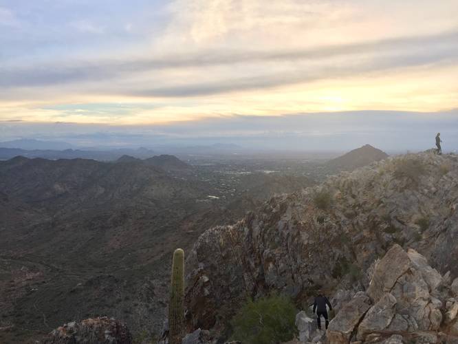
Hazards
Seasons
All
1 Trip Report


Helpful Links
Find Hiking Trails Near Me:


Before you leave...
MyHikes is an indie web platform aimed to make exploring public trails easier for everyone. The site has no investors and is owned and operated by one person, Dave Miller (Founder & Admin). As the Founder, main contributor, and doer-of-all-things for MyHikes, I share my trips with over-detailed write-ups for fun on a volunteer basis and I believe that public trail information should be available to everyone.
It takes a lot of time 🕦, money 💰, and effort (including espresso shots ☕) to run MyHikes, including hiking , mapping , writing , and publishing new trails with high-quality content... along with building new features, moderating, site maintainance, and app development for iOS and Android . I simply ask that if you find MyHikes' trail guides helpful to please consider becoming a Supporter to help keep the site, iOS, and Android apps available to everyone.
Supporters unlock website and in-app perks with a one-time payment of $25 (you renew) 😎👍. Or you can simply make a Donation of your choice without a MyHikes user account. Otherwise, telling your friends about MyHikes is the next-best thing - both quick and free 🎉
Thanks for visiting MyHikes and have a great hike!️

Dave Miller
MyHikes Founder & Admin

