Oxbow Falls
Distance:
0.1 Miles / 0.2 kmType:
Out-and-BackDifficulty:
EasyTime to Hike:
~5 minutesFeatures:
Surface Type:
DirtLoading...
Loading...
Oxbow Falls at Tioga State Forest near Cedar Run, Pennsylvania is an easy 0.1-mile out-and-back hike that leads to a small, and likely seasonal, waterfall named Oxbow Falls.
Hike Description
This off-trail hike begins at the sharp curve in Leetonia Road near the parking coordinates provided and follows a loosely-defined deer trail that leads up Oxbow Hollow to reach a small rock overhang where the creek cascades down, forming a waterfall during rainy seasons. This creek (Oxbow Run / Oxbow Creek) is not listed on any maps, hence, is likely a seasonal stream, so this waterfall will likely dry up by the time Summer rolls around.
Oxbow Falls - 8-feet tall
At the end of this GPS recording is the ~8-foot tall Oxbow Falls. To reach a decent view of the waterfall, up close, hikers must do some light scrambling to make their way up the hill. Be careful as some of this terrain is a bit steep. Once at the waterfall, hikers can enjoy a nice view of the falls before heading out.
Parking
Note that there's a tiny parking turnout by the coordinates provided along the bend in Leetonia Road. There's enough room for 1 or 2 cars maximum; however, your visit will be extremely short since the waterfall is visible from the road as well.
Pets
Dogs are allowed if leashed and their waste should be carried out by the hiker.
-
Parking
41.528887, -77.452979 -
Main Trailhead
41.528926, -77.453028 -
Oxbow Falls, approx. 8-feet tall
41.528972, -77.453422
Hazards
Seasons
All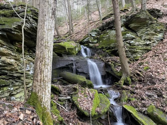
1 Trip Report


Helpful Links
Find Hiking Trails Near Me:


")

Before you leave...
MyHikes is an indie web platform aimed to make exploring public trails easier for everyone. The site has no investors and is owned and operated by one person, Dave Miller (Founder & Admin). As the Founder, main contributor, and doer-of-all-things for MyHikes, I share my trips with over-detailed write-ups for fun on a volunteer basis and I believe that public trail information should be available to everyone.
It takes a lot of time 🕦, money 💰, and effort (including espresso shots ☕) to run MyHikes, including hiking , mapping , writing , and publishing new trails with high-quality content... along with building new features, moderating, site maintainance, and app development for iOS and Android . I simply ask that if you find MyHikes' trail guides helpful to please consider becoming a Supporter to help keep the site, iOS, and Android apps available to everyone.
Supporters unlock website and in-app perks with a one-time payment of $25 (you renew) 😎👍. Or you can simply make a Donation of your choice without a MyHikes user account. Otherwise, telling your friends about MyHikes is the next-best thing - both quick and free 🎉
Thanks for visiting MyHikes and have a great hike!️

Dave Miller
MyHikes Founder & Admin

