Cucumber Falls
Distance:
0.2 Miles / 0.3 kmType:
Out-and-BackDifficulty:
EasyTime to Hike:
~6 minutesFeatures:
Surface Type:
DirtLoading...
Loading...
The Cucumber Falls Trail at Ohiopyle State Park in Ohiopyle, Pennsylvania is an amazing 0.2-mile out-and-back trail that leads down to Cucumber Falls. Cucumber Falls is a 30-foot tall waterfall that spills down from the Cucumber Run creek.
The hike down to the falls is very easy as the trail is mostly steps which leads out to the creek and pool that the falls feeds into. This trail may be considered moderate for those with disabilities due to the number of steps needed to hike down. Alternatively, there are great views of the waterfall without having to walk the entire trail.
When you first hit the trail, you'll notice you can walk out to the top of the falls right off of the trail, which gives you a different view of the falls altogether.
Once at the bottom, you can hike around and behind the falls or follow the Cucumber Run down to the Youghiogheny River. If you stand along the river, you'll likely see whitewater rafters going by and other boaters on the river during warmer seasons.
Cucumber Falls is a must-see if you're visiting Ohiopyle State Park for the first time and is likely one of the best waterfalls in Pennsylvania. Prepare for plenty of foot traffic along this trail due to the waterfall's popularity.
Connecting trails: You can hop on the Great Gorge Trail or the Meadow Run Trail from here.
Hazards
Season
Summer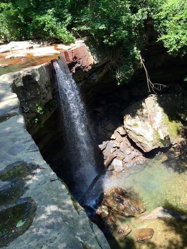

2 Trip Reports


Helpful Links
Find Hiking Trails Near Me:


Before you leave...
MyHikes is an indie web platform aimed to make exploring public trails easier for everyone. The site has no investors and is owned and operated by one person, Dave Miller (Founder & Admin). As the Founder, main contributor, and doer-of-all-things for MyHikes, I share my trips with over-detailed write-ups for fun on a volunteer basis and I believe that public trail information should be available to everyone.
It takes a lot of time 🕦, money 💰, and effort (including espresso shots ☕) to run MyHikes, including hiking , mapping , writing , and publishing new trails with high-quality content... along with building new features, moderating, site maintainance, and app development for iOS and Android . I simply ask that if you find MyHikes' trail guides helpful to please consider becoming a Supporter to help keep the site, iOS, and Android apps available to everyone.
Supporters unlock website and in-app perks with a one-time payment of $25 (you renew) 😎👍. Or you can simply make a Donation of your choice without a MyHikes user account. Otherwise, telling your friends about MyHikes is the next-best thing - both quick and free 🎉
Thanks for visiting MyHikes and have a great hike!️

Dave Miller
MyHikes Founder & Admin

